
Massachusetts, Rhode Island, and Connecticut Face Rain and Snow Showers Friday Night Into Saturday With Light Interior Accumulations Possible
SOUTHERN NEW ENGLAND — A developing weather system is expected to bring periods of rain and snow showers from Friday night through Saturday, impacting much of Massachusetts, Rhode Island, and Connecticut, according to the latest forecast data from the National Weather Service. While widespread heavy snow is not anticipated, light accumulations are possible in interior areas, especially north and west of the I-95 corridor, with changing precipitation types closer to the coast.
Forecasters say the system will move through in multiple waves, with precipitation beginning late Friday night and continuing into Saturday evening.
What Is Expected Friday Night Into Saturday
Weather data indicates on-and-off precipitation, beginning as snow in colder inland areas before mixing with or changing to rain in other locations.
Key details include:
- Snow showers developing Friday night
- A second round of rain/snow showers on Saturday
- Mixed precipitation near the coast
- Higher snow potential inland and west of I-95
Coastal communities across eastern Massachusetts and Rhode Island are more likely to see rain or a brief rain-snow mix, while interior sections of western and central Massachusetts and northern Connecticut remain colder.
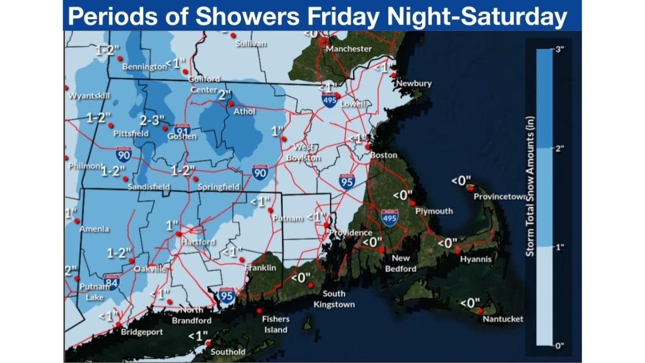
Where Snow Is Most Likely to Accumulate
The highest chance for measurable snow is expected in interior southern New England, particularly:
- Western and central Massachusetts
- Interior northern Connecticut
- Areas north and west of the I-95 corridor
Snowfall forecasts show generally lighter amounts near the coastline, with totals decreasing sharply toward eastern Massachusetts, Cape Cod, and Rhode Island’s coastal areas.
Expected Snow Amounts
Forecast guidance highlights light accumulations overall, but some inland areas may see enough snow to affect travel.
Projected totals include:
- Friday night: A coating up to 2 inches
- Saturday: An additional 1 to 2 inches mainly in interior locations
- Coastal areas: Mostly rain or minimal snow accumulation
Higher elevations and colder inland zones could see slightly higher localized totals, though widespread significant snowfall is not expected.
Travel and Safety Impacts
While this is not a major winter storm, slick roads and reduced visibility are possible at times, especially overnight and early Saturday.
Drivers should be prepared for:
- Slushy or snow-covered roads inland
- Wet roads near the coast
- Rapid changes between rain and snow
- Reduced visibility during heavier showers
Residents with Saturday morning travel plans should monitor conditions closely, particularly in interior areas.
What Residents Should Do
Weather officials recommend staying alert as details continue to be refined.
Helpful preparation steps include:
- Monitor updated forecasts frequently
- Allow extra travel time Friday night and Saturday
- Prepare for rapidly changing road conditions
- Have alternate plans if traveling inland
Stay Informed
Weather conditions can shift quickly in southern New England. Continue following Waldron for the latest updates, local impacts, and forecast changes as this system moves through.
Have you noticed snow or rain in your area yet? Share your local conditions and stay connected with Waldron for ongoing weather coverage.