
Georgia, South Carolina, and North Carolina Face Intensifying Cold as Light Snow Chances Develop Sunday Night
UNITED STATES — Forecasters are closely monitoring a developing winter weather setup that could bring very cold temperatures, gusty winds, and a low but notable chance of light snow across parts of Georgia, South Carolina, and coastal North Carolina late Sunday into early next week. While confidence in widespread snowfall remains low, confidence is high that dangerously cold mornings and wind chills will impact the region Monday through Wednesday.
What the Latest Forecast Shows Right Now
Recent forecast data shows a strong surge of Arctic air pushing into the Southeast following a cold frontal passage. This will set the stage for below-normal temperatures and potential wintry precipitation, especially inland.
Key temperature signals include:
- Highs mainly in the mid-30s to mid-40s
- 5 to 15 degrees colder than normal
- Sunday and Tuesday expected to be the coldest days
- Overnight lows dipping into the 20s and lower 30s across many inland locations
Wind chills may feel even colder during the morning hours, particularly where winds remain elevated.
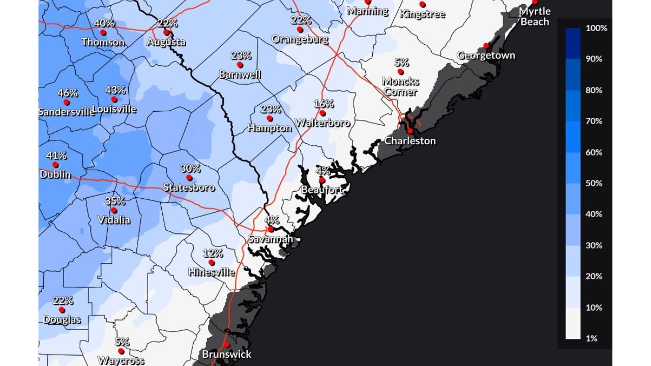
Snow Chances: Where They Are Highest and Lowest
Forecast probability maps indicate low to moderate chances for at least 0.1 inches of snow, mainly west of the immediate coastline.
Current probability ranges:
- 30–45% chance across parts of inland southeast Georgia
- 20–30% chance across interior South Carolina counties
- Below 10% near coastal areas including Charleston, Savannah, and Myrtle Beach
These probabilities suggest that most locations will see little to no accumulation, but brief snow showers or flurries remain possible if temperatures cool quickly enough during precipitation.
Timing: When Impacts Are Most Likely
The primary window for any wintry weather appears to be:
- Late Sunday night into early Monday morning
- Lingering cold and wind chills Monday through Wednesday mornings
Any snow that does fall would likely be light, brief, and patchy, but could still create slick spots on bridges, overpasses, and untreated roads, especially during the early morning commute.
What Forecasters Are Still Watching Closely
There remains uncertainty regarding:
- The exact track of the developing low-pressure system
- How quickly temperatures drop during precipitation
- The duration of any wintry mix or snow showers
Even small shifts in temperature or timing could change impacts, especially in inland counties.
How Residents Should Prepare Now
Officials recommend taking simple precautions ahead of the cold spell:
- Monitor updated forecasts frequently
- Prepare for very cold mornings, especially vulnerable populations
- Protect exposed pipes and pets from freezing conditions
- Use caution while driving during early morning hours
Bottom Line
While significant snow is unlikely, the combination of very cold air, gusty winds, and even light wintry precipitation could still create localized travel issues and uncomfortable conditions across parts of the Southeast early next week. Residents should stay alert as confidence in the cold grows, even as snowfall details continue to evolve.
Stay connected with Waldron for ongoing winter weather updates, local impact alerts, and the latest forecast changes as this cold pattern unfolds.