
Texas, Louisiana, Mississippi, Alabama, Georgia, Tennessee, Ohio, Michigan, and Wisconsin Brace for Reinforcing Arctic Blast With Subzero Lows Early Next Week
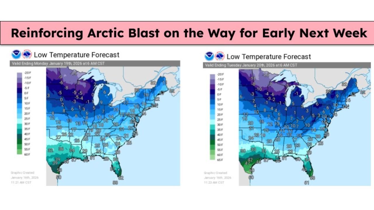
UNITED STATES — A reinforcing Arctic air mass is set to surge across a large portion of the country early next week, bringing dangerously cold overnight temperatures from parts of the Deep South through the Ohio Valley and into the Great Lakes. Forecast low-temperature maps for Monday and Tuesday mornings show widespread teens and single digits, with subzero lows expected across the Upper Midwest and northern Great Lakes.
Meteorologists warn that this will not be a brief cold snap. Instead, a second push of Arctic air will reinforce already cold conditions, increasing the risk of frostbite, hypothermia, frozen pipes, and stress on power systems, especially during the overnight and early-morning hours.
What the Temperature Forecast Shows
Forecast data valid for Monday morning (January 19) and Tuesday morning (January 20) highlights how expansive this cold outbreak will be:
- Upper Midwest & Great Lakes:
- Lows from 0°F to -15°F, with the coldest pockets in northern Minnesota, Wisconsin, and Michigan.
- Wind chills may drop well below zero, making outdoor exposure dangerous within minutes.
- Ohio Valley, Mid-South & Tennessee Valley:
- Single digits to low teens expected overnight.
- Areas that typically stay above freezing in winter may see their coldest readings of the season.
- Southern Plains & Deep South:
- Teens and low 20s extending unusually far south into Texas, Louisiana, Mississippi, Alabama, Georgia, and parts of the Carolinas.
- Some locations near the Gulf Coast may briefly dip close to freezing, posing risks to sensitive vegetation.
- East Coast:
- Teens to low 20s from the Mid-Atlantic into New England.
- Urban areas may remain slightly warmer, but still well below seasonal averages.
Why This Arctic Blast Is Especially Dangerous
This cold event is considered hazardous not just because of how cold it gets, but because of how widespread and persistent it will be.
- Extended exposure: Two consecutive mornings of extreme cold increase health risks.
- Infrastructure stress: Frozen pipes and heating system failures become more likely.
- Power demand spikes: High heating demand can strain local grids.
- Agricultural impact: Crops, livestock, and outdoor animals are vulnerable in southern states not acclimated to such cold.
Follow the “4 Ps” to Stay Safe
Officials urge residents to take the cold seriously and follow the 4 Ps of cold-weather safety:
People:
-
- Limit time outdoors.
- Dress in layers and cover exposed skin.
- Check on elderly neighbors and those without reliable heat.
Pets:
-
- Bring pets indoors whenever possible.
- Ensure outdoor animals have adequate shelter, bedding, and unfrozen water.
Plants:
-
- Cover sensitive plants or move them indoors.
- Disconnect hoses and protect outdoor faucets.
Pipes:
-
- Let faucets drip overnight to prevent freezing.
- Open cabinet doors under sinks to allow warm air circulation.
What Happens Next
While temperatures may moderate slightly later in the week, forecasters caution that winter is far from over. Long-range signals suggest additional cold intrusions remain possible as Arctic air continues to build across Canada.
Residents across the affected regions should monitor local forecasts, prepare homes now, and avoid underestimating the dangers of prolonged cold. Even areas accustomed to winter weather can face serious impacts when temperatures plunge this sharply.
Staying prepared over the next several days could make a critical difference as this reinforcing Arctic blast grips much of the country.