
Ohio and Pennsylvania See Widespread Lake-Effect Snow as January 14–15 Storm Delivers Up to 15 Inches in the Snowbelt
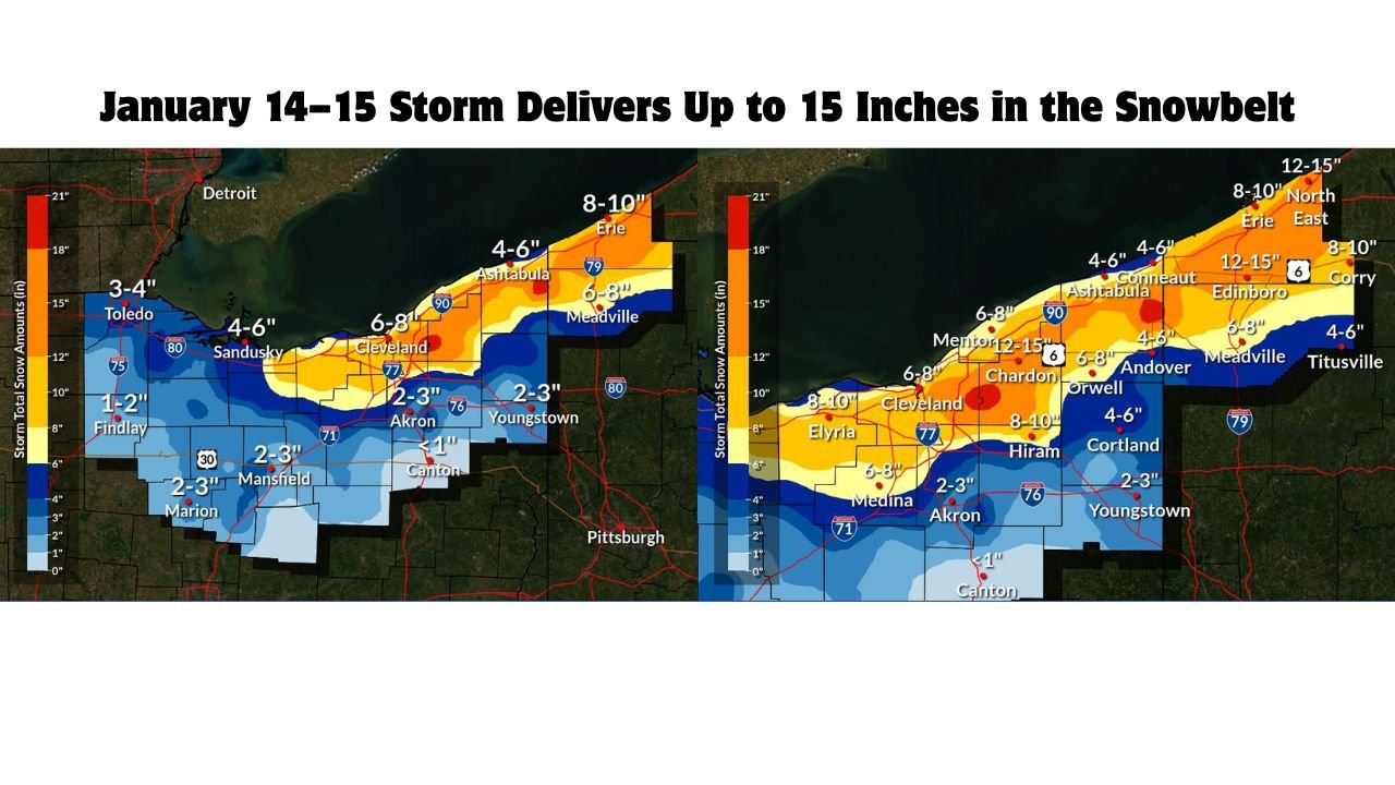
OHIO — A powerful lake-effect snow event swept across northeast Ohio and northwest Pennsylvania between January 14 and January 15, 2026, producing widespread snowfall with the heaviest accumulations concentrated along the Lake Erie snowbelt. Observed snowfall data from the event confirms double-digit totals in multiple communities, with localized peaks reaching 12 to 15 inches.
The storm developed as cold Arctic air surged over the relatively warmer waters of Lake Erie, creating persistent lake-effect snow bands that remained locked in place for hours. This setup allowed snow to accumulate rapidly in favored locations while areas just south of the snowbelt saw much lighter totals.
Heaviest Snowfall Focused in Northeast Ohio
Snowfall observations show northeast Ohio taking a direct hit, especially across Cuyahoga, Lake, Geauga, and Ashtabula counties.
Highest totals in Ohio included:
- Chardon, OH: 12–15 inches
- Cleveland east side & nearby suburbs: 8–10 inches
- Mentor and surrounding Lake County areas: 6–8 inches
- Ashtabula, OH: 4–6 inches, with higher amounts just inland
These areas remained under intense lake-effect bands for much of the event, leading to hazardous travel conditions and rapidly snow-covered roadways.
Northwest Pennsylvania Also Buried by Snowbelt Bands
Across the state line, northwest Pennsylvania experienced some of the highest totals of the entire storm, particularly in Erie and Crawford counties.
Notable Pennsylvania snowfall totals:
- Edinboro, PA: 12–15 inches
- Erie, PA: 8–10 inches
- Corry, PA: 8–10 inches
- Meadville, PA: 6–8 inches
- Titusville, PA: 4–6 inches
The snowfall gradient was sharp, with totals dropping quickly south of the snowbelt as lake-effect bands weakened.
Lighter Snow South of the Snowbelt
Areas farther south across central Ohio saw much lower accumulations due to limited lake influence.
- Akron, OH: 2–3 inches
- Youngstown, OH: 2–3 inches
- Canton, OH: Less than 1 inch
- Medina, OH: 6–8 inches, closer to the snowbelt edge
This sharp contrast highlights the localized nature of lake-effect snow, where a difference of just a few miles can mean several inches more or less snowfall.
Why This Snowfall Event Was Significant
This storm stands out not just for totals, but for how concentrated and persistent the snow bands were.
- Long-lasting lake-effect bands remained nearly stationary
- Cold Arctic air enhanced snow growth and accumulation
- High snowfall rates led to rapid travel deterioration
- Snowbelt communities experienced some of their heaviest snow so far this winter
With additional Arctic air and lake-effect potential still in the pattern, snowbelt areas of Ohio and Pennsylvania may see more accumulating snow in the days ahead.
Residents are urged to stay alert to changing conditions, allow extra travel time, and continue monitoring local forecasts as winter weather remains firmly in control across the Great Lakes region.