
Maryland, Northern Virginia, and Washington, D.C. See Snow Forecast Increased to 1–2 Inches in Northern Suburbs as Early-Morning Burst Raises Travel Concerns
WASHINGTON, D.C. — Forecasters have increased expected snowfall totals for northern suburbs of the Washington, D.C. metro area to 1–2 inches, up from earlier projections of just a coating to 1 inch, as short-term models now show a concentrated burst of snow early Sunday morning. The update comes as temperatures are already at or below freezing, allowing snow to accumulate more efficiently and increasing the risk of slick roads, walkways, and reduced visibility during the most sensitive travel window.
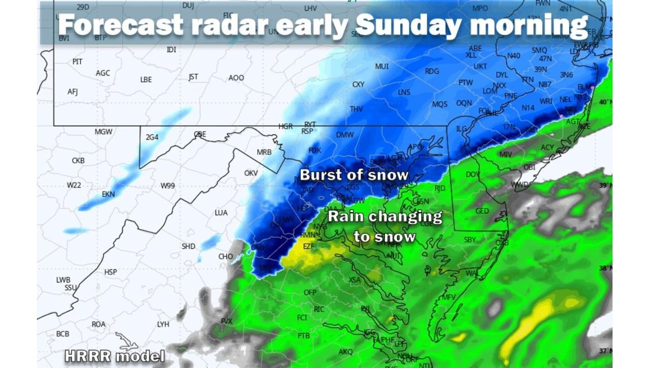
The heaviest impacts are expected north and west of the Capital Beltway, while areas farther south and east will see lighter, more surface-dependent accumulation.
Why the Snow Forecast Was Increased
Meteorologists point to two key factors behind the upward adjustment:
- Freezing temperatures already in place, preventing snow from melting on contact
- Strong short-term model support for a brief but intense burst of snow between roughly 5 a.m. and 8 a.m. Sunday
That narrow window is expected to produce the worst travel conditions of the event, with snowfall rates briefly high enough to coat untreated roads and reduce visibility, even though the system is relatively fast-moving.
Expected Snow Totals by Area
Based on the latest guidance, snowfall will vary sharply across short distances:
- Northern Maryland suburbs (Frederick, areas north of Baltimore):
- 1–2 inches, with a 20% chance of 2–4 inches if the snow band intensifies
- Northern & Western D.C. suburbs (Montgomery County MD, Loudoun & Fairfax counties VA):
- 1–2 inches, with slick roads and walkways likely
- Washington, D.C. proper:
- Coating to 1 inch, with accumulation mainly on grassy and elevated surfaces
- Southern & Eastern Maryland / Southern Virginia suburbs:
- Little accumulation, mostly rain changing briefly to snow
Forecasters also note a 20% chance of a bust in some locations if the snow band weakens or shifts slightly.
Timing: When Conditions Will Be Worst
The overall event is expected to be short, but timing is critical:
- Late Saturday night: Rain transitions to snow from northwest to southeast
- Early Sunday morning (5–8 a.m.):
- Burst of snow, worst travel conditions
- Slick spots and reduced visibility likely
- Mid to late Sunday morning: Snow tapers off quickly
Because of the timing, early-morning drivers, airport operations, and public transit could see the greatest impacts despite modest totals.
What to Expect on Roads and Walkways
Even 1–2 inches can cause problems when snow falls quickly on frozen surfaces.
Potential impacts include:
- Slick highways and neighborhood roads, especially north and west of the Beltway
- Snow-covered sidewalks and parking lots
- Brief flight or travel delays during the morning push
Officials urge drivers to slow down, allow extra stopping distance, and be alert for sudden changes in road conditions.
Bottom Line for the D.C. Metro Region
This is not a major winter storm, but the combination of freezing temperatures and a concentrated burst of snow is enough to justify increased caution. The forecast increase to 1–2 inches for northern suburbs of Maryland, northern Virginia, and areas near Washington, D.C. reflects growing confidence in short-term model guidance.
Residents should plan for minor but meaningful travel impacts Sunday morning, especially in northern and western suburbs, and continue to monitor updates as the system approaches.