
New York, New Jersey and the Northeast Could Enter a Memorable Late-January Cold and Winter Weather Stretch
UNITED STATES — A potentially historic period of winter weather is beginning to show up in long-range guidance for New York City and the broader Northeast, with model data signaling an unusually intense blast of Arctic air arriving in late January and possibly setting the stage for impactful winter conditions across New York, New Jersey, Pennsylvania, and New England.
While exact snowfall details remain uncertain this far out, the temperature signal alone is strong enough to raise concern, with forecasts pointing to extreme cold anomalies rarely seen this late in the season.
What the Latest Data Is Showing
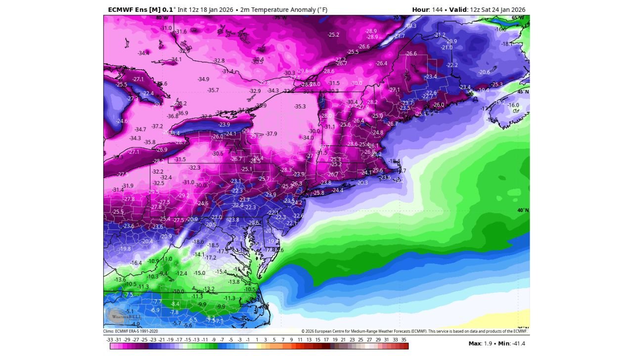
Long-range ensemble guidance highlights a deep pool of Arctic air spreading across the Great Lakes, Mid-Atlantic, and Northeast around January 24–26, with New York City firmly inside the core of the cold.
Temperature anomaly maps indicate:
- 20 to 30 degrees below normal across much of New York State
- Sub-zero anomalies extending into New Jersey and eastern Pennsylvania
- One of the coldest late-January air masses in several years for the Northeast
If these projections verify, daytime highs in and around NYC could struggle well below normal, with overnight lows plunging sharply and dangerous wind chills becoming a real concern.
Why This Pattern Is Getting Attention
What makes this setup notable is the breadth and intensity of the cold signal across multiple model runs. The Arctic air mass appears well-established, not just a brief cold snap, suggesting a multi-day stretch of severe winter conditions rather than a one-night event.
Forecasters are watching:
- A strong northern blocking pattern
- Sustained Arctic high pressure pressing southward
- A jet stream configuration that allows cold air to remain locked in place
This type of pattern often favors persistent cold, not quick moderation.
Snow and Winter Weather Potential Still Unclear
At this stage, the data is not yet specific about snowfall, but historically, setups like this raise the risk for:
- Snow events if storm systems track nearby
- Icy conditions if moisture overruns shallow cold air
- Travel disruptions even without major snowfall due to extreme cold
In many past cases, significant cold precedes or accompanies impactful winter storms in the Northeast, which is why forecasters are emphasizing awareness rather than certainty right now.
What This Could Mean for NYC and Surrounding Areas
If the pattern holds, residents across New York City, Long Island, northern New Jersey, and the Hudson Valley could experience:
- Prolonged bitter cold
- Increased risk of frozen pipes and infrastructure stress
- Elevated heating demand and energy usage
- Hazardous outdoor conditions due to wind chill
Even without heavy snow, extreme cold alone can disrupt daily life across dense urban areas.
Timing and Next Steps
This potential cold stretch is still several days away, and details will evolve. Forecast confidence will improve significantly:
- By midweek, as short-range models come into range
- By Thursday or Friday, when snowfall and precipitation threats can be better defined
For now, the message is not panic — but preparation.
Bottom Line
A memorable late-January winter pattern is increasingly likely for New York City and the Northeast, driven by a powerful Arctic air mass that could deliver some of the coldest conditions of the season. Whether this evolves into a major snow event or remains primarily a cold outbreak, the signal is strong enough to warrant close monitoring.
Stay tuned to Waldron News for continued updates as this developing winter threat becomes clearer over the coming days.