
Alabama, Georgia, Tennessee, and the Ohio Valley Face Growing Late-Week Winter Storm Threat With Ice and Heavy Snow Possible
UNITED STATES — A potentially disruptive winter weather pattern is beginning to take shape across Alabama, Georgia, Tennessee, Kentucky, and parts of the Ohio Valley as forecasters monitor early signals of a developing winter storm late this week into the weekend. While details are still evolving, multiple model indicators suggest freezing rain, ice accumulation, and heavy snow could impact large portions of the South-Central and Southeast U.S.
Early Sunday Snow in Alabama Ends Quietly, Focus Shifts Ahead
Sunday morning’s light winter weather event in southeast Alabama unfolded largely as expected, producing only minor, short-lived snow accumulation on grassy surfaces. Afternoon sunshine quickly erased most of the evidence, and impacts were minimal.
With that system now out of the way, attention has turned to a much more significant and potentially disruptive winter setup developing later in the week.
European Model Flags Freezing Rain Risk Across Northern Alabama
Recent runs of the European global weather model (ECMWF) are raising concern for an extended period of freezing rain, particularly across northern Alabama, with spillover risk into southern Tennessee and northern Georgia.
If this scenario materializes, meaningful ice accumulation could occur, increasing the risk of:
- Hazardous road conditions
- Power outages from ice-laden trees and power lines
- Travel disruptions across major regional corridors
Some snow may mix in at times, especially north of the freezing rain zone, but ice appears to be the primary concern at this stage.
Forecast Uncertainty Remains High Due to Marginal Temperature Profiles
Despite concerning signals, meteorologists caution that low-level atmospheric thickness values remain marginal. This introduces a real possibility that parts of the region could instead experience cold rain rather than freezing rain, especially if surface temperatures fluctuate just above freezing.
This temperature sensitivity means small changes in storm track or timing could dramatically alter impacts, underscoring why confidence remains limited for now.
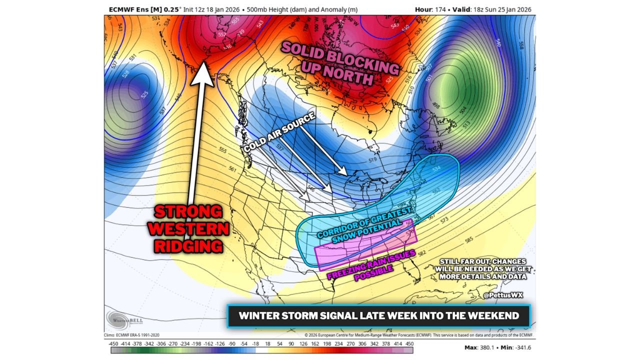
Heavy Snow Corridor Possible From the Deep South Into the Northeast
A broader pattern is also emerging that supports south-central and southeastern winter storm development, driven by:
- Strong western ridging
- Intense blocking over northern Canada
- A well-established cold air source feeding southward
Current guidance suggests the highest heavy snow potential may extend from portions of the Deep South northeastward toward the Ohio Valley and Mid-Atlantic, while freezing rain remains a major concern farther south.
Some ensemble guidance even shows mean ice accumulations near or above 0.50 inches, a level that would approach crippling impacts if realized.
Too Early for Specific Impacts, But Disruptive Scenario Is Plausible
Forecasters stress that it is too early to pin down exact snowfall or ice totals, and road condition forecasts are not yet possible. However, the overall signal of a significant winter weather event is clearly on the table.
Forecast confidence is expected to improve significantly by Wednesday, with more precise details likely available by Thursday as the system moves into better observational range.
What Residents Should Do Now
Residents across Alabama, Georgia, Tennessee, Kentucky, and surrounding states should:
- Monitor daily forecast updates
- Prepare for possible travel disruptions late week
- Stay alert for winter weather advisories or watches
Additional updates, including video briefings and refined forecasts, are expected as new data becomes available.
Stay informed and prepared — and continue following weather updates on WaldronNews.com as this developing winter storm threat becomes clearer.