
Arkansas, Oklahoma, Missouri and the Mid-South Face Growing Risk of a Late-Week Winter Storm With Snow, Ice and Arctic Cold
UNITED STATES — Forecast guidance is increasingly signaling a potentially significant winter weather setup late this week into next weekend, with Arkansas, Oklahoma, Missouri, northern Alabama, Tennessee and parts of the Mid-South emerging as key areas to watch for snow, freezing rain and disruptive cold. While details remain uncertain several days out, the overall pattern now shows one of the strongest winter storm signals of the season for this region.
Strong Arctic Pattern Taking Shape Across the Central and Eastern U.S.
Medium-range model guidance highlights a powerful Arctic air mass diving southward from Canada, supported by strong high-latitude blocking and western U.S. ridging. This configuration favors cold air becoming locked in place east of the Rockies while storm systems are forced to track along its southern edge.
Temperature anomaly maps show late-January readings running 20–35 degrees below normal across the Midwest, Ohio Valley, and interior Northeast, with single-digit highs and dangerous wind chills possible farther north. This cold air source is critical, as it increases the likelihood that any incoming system produces winter precipitation rather than rain.
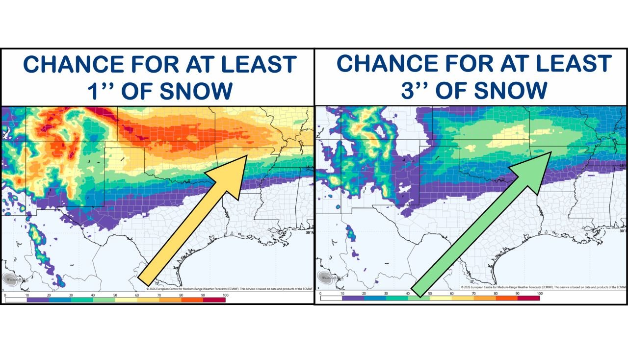
Snow Potential Focused From Oklahoma Into Arkansas and Missouri
Ensemble snowfall probability graphics show a developing corridor of accumulating snow stretching from central and northern Oklahoma through northern Arkansas and into southern Missouri. Current guidance indicates:
- A meaningful chance of at least 1 inch of snow across much of northern Arkansas and southern Missouri
- Lower but notable probabilities for 3 inches or more, especially where cold air is deepest and storm track aligns favorably
- A sharp cutoff to the south where warmer air intrudes
These probabilities remain preliminary, but the consistency across multiple ensemble runs suggests this is not a one-off model solution.
Ice and Freezing Rain Could Become the Bigger Threat
One of the most concerning signals is the potential for freezing rain, particularly across northern Alabama, southern Tennessee, and parts of Mississippi and Georgia. European ensemble data has at times indicated ice accretion approaching or exceeding 0.25–0.50 inches in localized areas — levels that can cause tree damage, power outages, and dangerous travel.
However, forecasters caution that low-level temperature profiles are marginal, meaning small shifts could turn freezing rain into cold rain, or vice versa. This makes the ice forecast highly sensitive and one of the main uncertainties heading into the week.
Southeast Alabama Event Confirms Cold Air Is Already in Place
A minor snow event in southeast Alabama earlier today produced light accumulations on grassy surfaces with little impact, melting quickly under afternoon sunshine. While insignificant on its own, the event confirms that cold air is already pressing south, setting the stage for more impactful winter weather should moisture arrive later this week.
Timing Still Uncertain, Confidence Increasing in Impacts
At this range, forecasters stress that specific timing and amounts cannot yet be locked in. Model solutions continue to adjust, and precipitation type will depend heavily on exact storm track and surface temperatures.
What is becoming clearer is that:
- Arctic cold is very likely across the central and eastern U.S.
- A storm system interacting with that cold air is plausible
- Snow and ice impacts are firmly on the table, especially for parts of the Mid-South
More refined forecasts are expected by Wednesday, with higher confidence by Thursday as the system enters better observational range.
What Residents Should Do Now
Even though details remain fluid, residents across Arkansas, Oklahoma, Missouri, Tennessee, Alabama and nearby states should begin early preparations:
- Monitor daily forecast updates from local weather offices
- Review winter driving and power outage plans
- Check heating systems and cold-weather supplies
- Avoid making firm travel plans late this week if possible
This setup has the potential to become one of the most disruptive winter weather events of the season for the Mid-South, especially if ice accumulations materialize.
Stay alert for updates as confidence continues to increase.
For continued coverage, forecast updates, and local impact breakdowns, stay connected with Waldron News throughout the week.