
Texas, Oklahoma, Arkansas, Louisiana, Mississippi, Alabama, Georgia, South Carolina, and North Carolina Face High-Impact Winter Storm Threat With Snow and Dangerous Ice Jan. 24–27
UNITED STATES — Forecast confidence continues to increase that a large, high-impact winter storm will affect a wide portion of the southern United States beginning as early as Friday, January 24, and potentially lasting into Monday, January 27. Updated European (ECMWF) deterministic and ensemble guidance shows a powerful storm system stretching from Texas and Oklahoma through the Deep South and into the Carolinas, bringing a dangerous combination of snow, sleet, and freezing rain to areas that rarely experience prolonged winter weather.
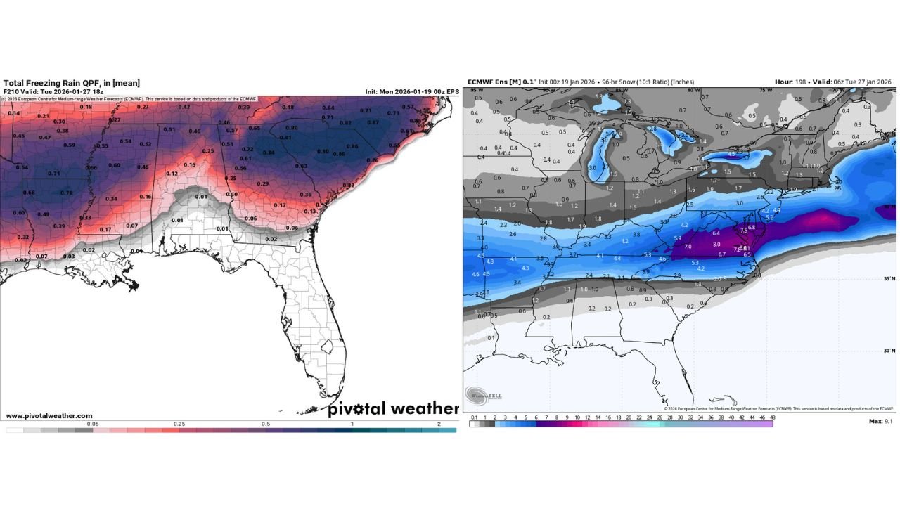
While the exact placement of the heaviest snow and ice remains uncertain, meteorologists are increasingly concerned about the ice storm signal, particularly across portions of the Southeast, where cold air at the surface may become locked in beneath warmer air aloft.
Why This Winter Storm Is Raising Red Flags
Unlike many winter systems that affect the Midwest or Northeast, this storm is notable for its southern latitude and expansive footprint. Model guidance shows a strong Arctic high-pressure system anchored to the north, funneling cold air southward into the Plains and Deep South.
At the same time, a low-pressure system ejecting from the Southwest is expected to track eastward across the southern Plains and Gulf states, overrunning that cold air with deep moisture. This setup is a classic recipe for widespread snow north of the low track and significant icing farther south, particularly where surface temperatures remain below freezing.
Snow Axis May Shift but Southern States Remain in Play
Current ECMWF ensemble snowfall probabilities indicate a broad snow band extending from north Texas and Oklahoma through Arkansas, Tennessee, and into the southern Appalachians. In some model scenarios, several inches of snow are possible within this corridor, especially where precipitation rates increase Saturday night into Sunday.
However, forecasters caution that any northward shift in the storm track could introduce warmer air aloft, converting heavy snow into sleet or freezing rain, while a southward shift would expand snowfall deeper into the Gulf states. This volatility makes precise snowfall forecasts impossible at this stage.
Ice Storm Risk Growing for the Southeast
The greatest concern emerging from the latest data is the potential for a significant ice storm, particularly across northern Georgia, South Carolina, and into central and western North Carolina. ECMWF freezing rain output highlights prolonged periods of freezing rain, with some areas showing ice accretion amounts that could exceed critical thresholds if trends hold.
Ice storms in these regions pose a serious threat due to:
- Power outages from downed trees and power lines
- Extremely hazardous travel conditions
- Extended recovery times, even after precipitation ends
Meteorologists emphasize that ice impacts can be far more disruptive than snow, especially in areas not accustomed to winter weather infrastructure.
Storm Duration Could Extend Impacts
Another factor adding complexity is the potential longevity of the system. If the southern-stream low slows or redevelops, precipitation could continue overrunning shallow Arctic air for an extended period, increasing both snow totals and ice accretion.
Even if the system progresses steadily eastward, waves of precipitation could impact the same regions over multiple days, compounding hazards and complicating response efforts.
What Could Still Change Before the Weekend
Despite the increasing confidence in a major winter storm, key uncertainties remain:
- The exact track of the surface low
- How deeply warm air intrudes aloft
- The strength and placement of Arctic high pressure
- Timing differences between moisture arrival and cold air depth
Small changes in any of these factors could dramatically shift the snow–ice transition zone by hundreds of miles.
What Residents Should Do Now
Forecasters stress there is no reason to panic, but now is the time to be weather-aware. Residents across Texas, Oklahoma, Arkansas, Louisiana, Mississippi, Alabama, Georgia, South Carolina, and North Carolina should:
- Monitor daily forecast updates
- Review winter travel and power outage plans
- Prepare for the possibility of extended icy conditions, not just snow
This is not a distant 7–10 day signal—the storm is approaching within the next several days, and confidence will sharpen quickly as higher-resolution data becomes available.
As winter weather threats evolve across the country, staying informed is critical. For continued winter storm updates, forecast analysis, and regional impact coverage, visit Waldronnews.com.