
Colorado Faces Large Hail and Tornado Risk Thursday May 21 Near La Junta, Lamar and Limon While Texas Panhandle and Oklahoma Face Large Hail Friday May 22 Including Amarillo, Woodward and Oklahoma City
LAMAR, Colorado – Localized severe weather risks continue across two separate regions over the next 48 hours, with eastern Colorado facing isolated supercells with large hail, damaging winds and a tornado or two on Thursday, May 21, before the threat shifts into the Texas Panhandle and western Oklahoma on Friday, May 22 with a primary large hail focus targeting Amarillo, Woodward and Oklahoma City.
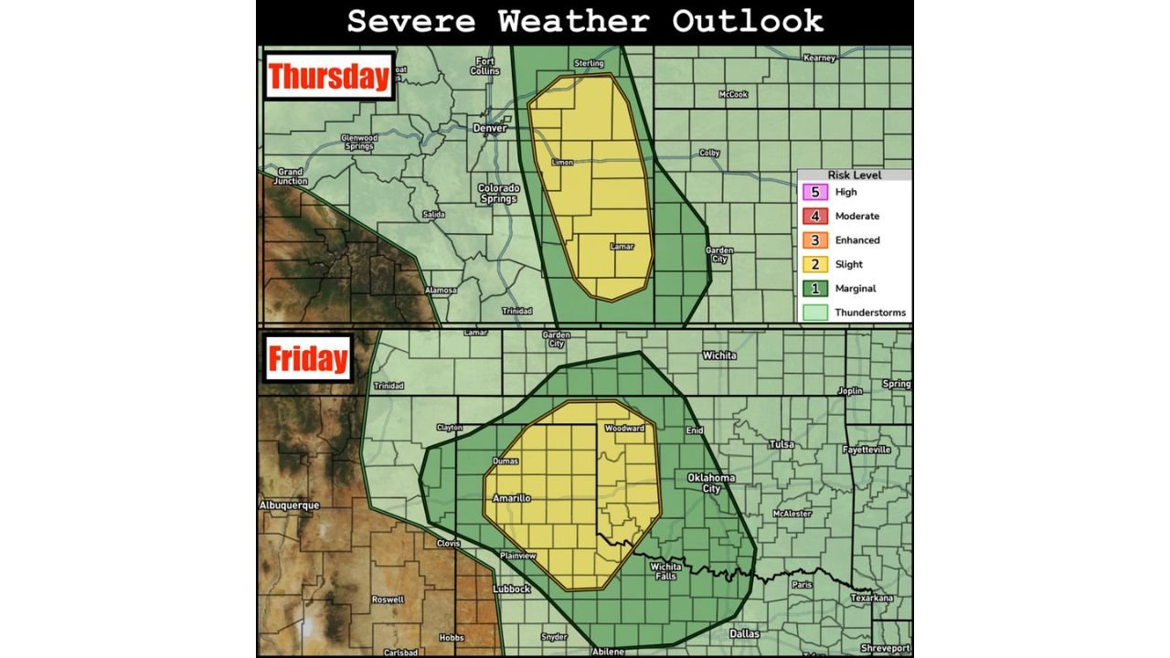
Thursday May 21: Eastern Colorado in the Crosshairs
The Thursday, May 21 severe weather outlook shows a Level 2 Slight Risk zone centered on eastern Colorado, with two specific corridors drawing the greatest concern.
The Highway 50 corridor of southeast Colorado including the La Junta and Lamar area is where isolated supercells are most likely to develop Thursday as adequate moisture streams into the region ahead of an upper level trough. The area near I-70 around Limon and areas east of Limon represent the second primary development corridor for Thursday, May 21. The Slight Risk zone on the map also covers Denver, Colorado Springs, Sterling and Fort Collins in the broader severe weather area Thursday.
| Thursday Threat | Details |
|---|---|
| Primary area | La Junta, Lamar, Limon, Colorado |
| Risk level | Level 2 Slight |
| Main threats | Large hail, damaging winds |
| Additional threat | Tornado or two possible |
| Broader zone | Denver, Colorado Springs, Sterling, Fort Collins |
Friday May 22: Threat Shifts to Texas Panhandle and Oklahoma
On Friday, May 22 the severe weather focus moves south and east into the Texas Panhandle and western Oklahoma, with a Level 2 Slight Risk zone covering Amarillo, Woodward, Enid, Dumas, Plainview, Wichita Falls and Oklahoma City.
Large hail is the primary concern on Friday, with a mix of multicell and supercell thunderstorms expected to develop across this corridor. Wind shear will not be as strong on Friday compared to Thursday, but it will be adequate to support organized storm development capable of producing significant hail. A broader Marginal Risk zone extends the thunderstorm threat into Wichita, Tulsa, Fayetteville, Dallas, Abilene, Lubbock, Roswell, Clayton and Texarkana on Friday, May 22.
| Friday Threat | Details |
|---|---|
| Primary area | Amarillo, Woodward, Oklahoma City, Wichita Falls |
| Risk level | Level 2 Slight |
| Main threat | Large hail |
| Storm mode | Mix of multicells and supercells |
| Broader zone | Wichita, Tulsa, Dallas, Lubbock |
Eastern Nebraska and South Dakota Also Worth Watching Friday
Forecasters are keeping an eye on eastern Nebraska and South Dakota on Friday, May 22 as the trough from Thursday ejects into the northern Plains. No formal risk area has been outlined for this region yet, but if adequate moisture reaches eastern Nebraska and South Dakota, a cold-core supercell risk could develop Friday. This is a lower-confidence addition to the Friday outlook but one worth monitoring as the day approaches.
What You Should Do
Anyone across the La Junta, Lamar and Limon, Colorado area needs to be weather-alert ready before Thursday afternoon, May 21. Amarillo, Woodward, Enid and Oklahoma City residents should monitor conditions closely before Friday afternoon, May 22. Large hail can develop with little warning and damage vehicles and property within seconds. Keep weather alerts active on your phone both Thursday and Friday.
WaldronNews.com will continue tracking these localized severe weather risks across Colorado, Texas and Oklahoma and will provide updates as supercell development, hail reports and tornado activity emerge on Thursday, May 21 and Friday, May 22.