
Georgia, Alabama, Tennessee and the Carolinas Face Potential High-Impact Ice Storm as Arctic High and Southern System Threaten Late January
UNITED STATES — Forecasters across the Southeast are closely monitoring a developing winter weather threat late next week, as a powerful Arctic high-pressure system is expected to push cold air deep into the region while a potential southern storm system attempts to track eastward. If current trends verify, parts of Georgia, Alabama, Tennessee, North Carolina, and South Carolina could face a significant ice storm, though critical details remain uncertain.
Early Flurries Fade as Cold Air Lags Behind Moisture
Reports of brief flurries west of Interstate 95 in parts of South Carolina earlier today failed to accumulate, as cold air was unable to catch up to outgoing moisture. Rain is expected to fully end shortly, but temperatures dropping behind the system may create black ice hazards overnight, particularly on bridges and untreated roadways.
While this system exits quietly, it has shifted meteorologists’ focus toward a much more concerning setup heading into next weekend.
Why This Next System Has Meteorologists Concerned
Unlike many overhyped winter threats, this potential storm is drawing attention because nearly every major forecast model is signaling the same general setup. Guidance shows a strong Arctic high funneling subfreezing air into the Southeast at the same time a storm may develop across the Deep South.
Southern-track systems often present the highest winter weather risk for this region, as they can pull in Gulf moisture while cold air presses south. That overlap raises the threat for freezing rain and ice accretion, which can be far more damaging than snow.
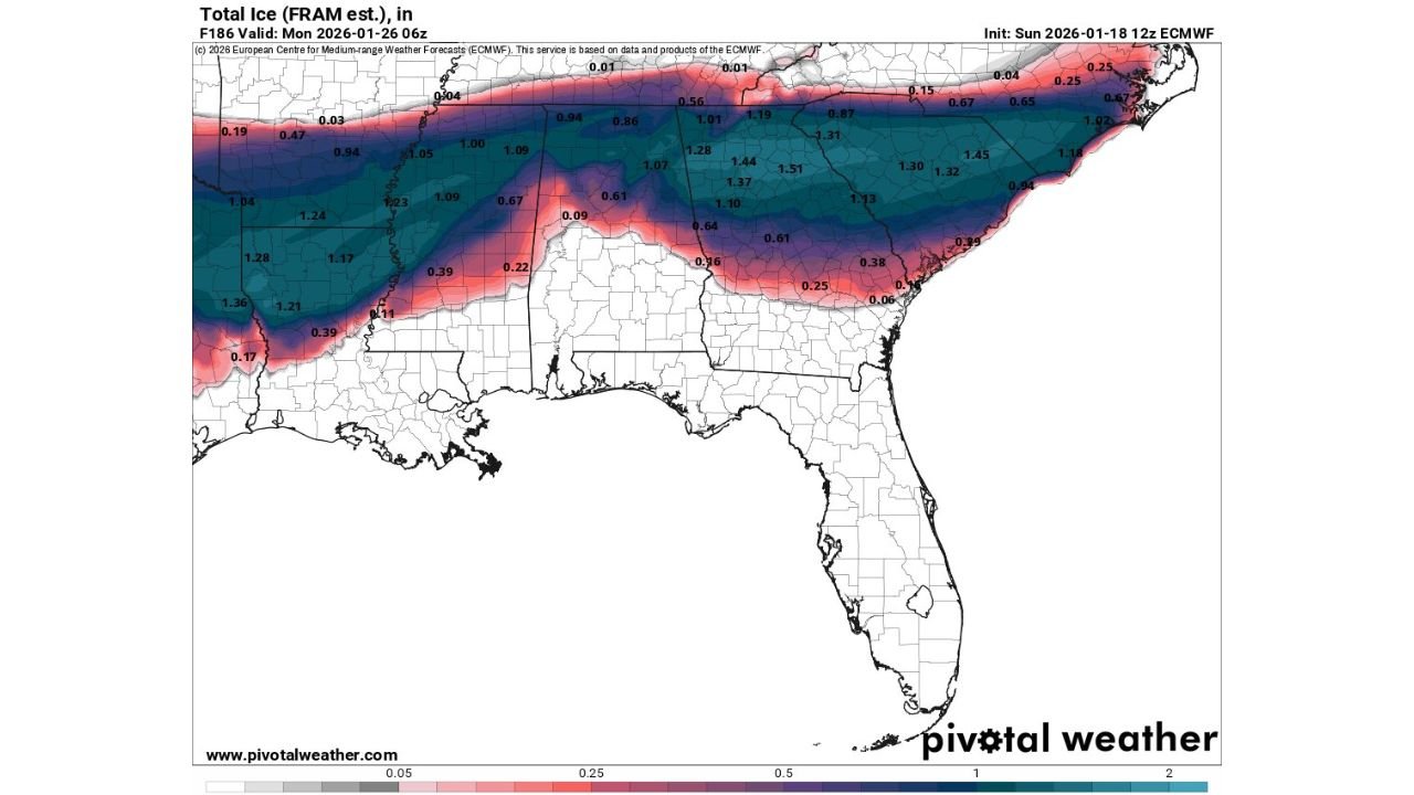
Ice Accretion Could Be Significant if Models Verify
Recent model output indicates the possibility of very high ice accretion totals, especially across portions of central and northern Georgia, eastern Alabama, southern Tennessee, and parts of the Carolinas.
Some guidance suggests over one inch of ice accumulation in parts of the region — an amount capable of causing:
- Widespread power outages
- Downed trees and power lines
- Dangerous road conditions
- Long recovery times
Even forecasters who typically avoid alarm are expressing serious concern, noting this is a scenario that would require close monitoring.
Temperature Margins Are Razor Thin
One of the most critical uncertainties involves temperature placement. Forecasters note that a difference of just one degree could dramatically change outcomes:
- Slightly warmer: cold rain
- Slightly colder: freezing rain or sleet
- Ideal overlap: damaging ice storm
While temperatures are expected to be right on the edge, the presence of a very strong Arctic high increases the odds that cold air could hold in place longer than usual.
Storm Track Will Decide Everything
Even if the storm develops, its exact path will determine impacts:
- Too far north: Mainly rain
- Too far south: Cold but dry
- Just right: Prolonged freezing rain and ice
At this time, the region remains about six days out, meaning mesoscale details such as surface temperatures, precipitation intensity, and cold air depth are still unresolved.
Why Forecasters Are Urging Caution, Not Panic
Despite concerning signals, meteorologists stress that nothing is locked in. Systems at this range can still weaken, shift south, or fail to develop altogether. However, the consistency across multiple models makes this one worth taking seriously.
Residents are encouraged to monitor National Weather Service updates closely as confidence increases later this week.
What Residents Should Do Now
Across Georgia, Alabama, Tennessee, North Carolina, and South Carolina, residents should:
- Stay informed through trusted forecasts
- Prepare for potential power disruptions
- Avoid reacting to early snowfall or ice maps alone
- Be ready for rapid forecast changes
This setup has the potential to become a high-impact winter storm, but it remains highly sensitive to small atmospheric changes. Clarity will improve significantly over the next several days.
Stay with Waldron News for continued updates, refined timelines, and state-specific impact guidance as this developing winter threat comes into focus.