
Texas, Oklahoma, Arkansas, Tennessee, Virginia and the Carolinas Face Multi-Day Winter Storm Risk as Arctic Cold and Southern System Align Friday Through Sunday
UNITED STATES — Forecast confidence is increasing that a large, multi-state winter weather event could unfold from Friday through Sunday, as dangerous Arctic cold overspreads much of the country and a southern storm system attempts to track from the Southern Plains into the Mid-Atlantic. Ensemble guidance from both the GEFS and EC-EPS continues to show a similar signal, raising concern for widespread snow and ice impacts across parts of Texas, Oklahoma, Arkansas, Tennessee, Kentucky, Virginia, North Carolina, and surrounding states.
Dangerous Arctic Cold Sets the Stage Nationwide
This setup begins with an exceptionally cold Arctic air mass spreading across much of the United States. Forecast wind chill maps show subzero wind chills for more than 100 million people, with the Northern Plains potentially seeing wind chills as low as 40 to 60 degrees below zero.
That cold air is not staying confined to the north. Instead, it is expected to press deep into the central and southern states, creating a classic environment where winter storms can turn high-impact very quickly.
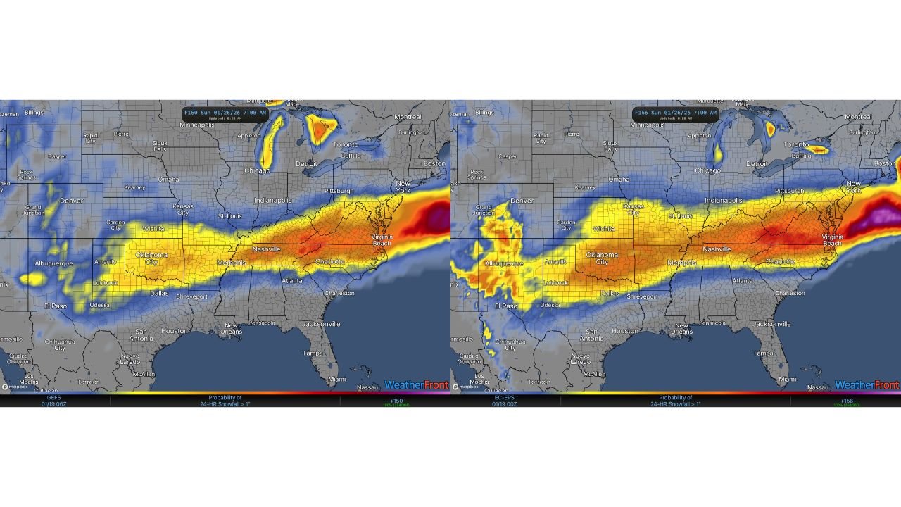
Potential Winter Storm Track: Southern Plains to the Mid-Atlantic
Both major ensemble systems depict a storm developing over the Southern Plains and tracking east-northeast toward the Tennessee Valley and Mid-Atlantic between Friday and Sunday.
This type of track historically favors widespread winter precipitation, especially when cold air is already entrenched at the surface. States most closely aligned with the projected corridor include:
- Texas and Oklahoma
- Arkansas and northern Louisiana
- Tennessee and Kentucky
- Virginia and West Virginia
- North Carolina and parts of the Carolinas
Small shifts north or south will still matter, but the overall signal remains consistent across guidance.
Snow Potential: Accumulating, With Localized Heavy Totals
Current ensemble probabilities indicate a high likelihood of accumulating snow along much of the storm track. Some guidance suggests a real possibility of 6 inches or more in parts of:
- Eastern Oklahoma
- Northern Arkansas
- Central and eastern Tennessee
- Portions of Virginia and North Carolina
The heaviest snow axis will ultimately depend on exact storm placement, but the signal for meaningful accumulation is already present several days out.
Ice Threat on the Southern Edge of Heavy Snow
One of the most concerning aspects of this setup is the ice potential along the southern edge of the snow band. Model data shows scenarios where cold air at the surface undercuts warmer air aloft, creating an environment favorable for freezing rain.
Ice accretion is most likely across parts of:
- Southern Arkansas
- Northern Mississippi
- Northern Alabama
- Southern Tennessee
- Interior portions of the Carolinas
Even modest ice amounts can lead to power outages, tree damage, and dangerous travel, making this a key detail to monitor closely.
Why This Setup Is Being Taken Seriously
While details are still evolving, meteorologists are paying close attention because:
- Multiple ensemble systems agree on timing and track
- Arctic air is already firmly established
- The storm window spans multiple days
- Impacts could include snow, ice, and extreme cold simultaneously
At this range, exact snowfall and ice totals remain to be determined, but the large-scale pattern is locked in enough to justify heightened awareness.
What Residents Should Do Now
Across Texas, Oklahoma, Arkansas, Tennessee, Virginia, North Carolina, and neighboring states, residents should:
- Monitor forecast updates daily
- Prepare for dangerous cold exposure
- Plan for potential travel disruptions
- Be ready for power outages where ice develops
- Avoid focusing on single snowfall maps this early
This evolving winter threat has the potential to become one of the more impactful systems of the season, especially if snow and ice overlap with dangerous Arctic cold.
Stay with Waldron News for continued updates, refined impact zones, and state-specific guidance as forecast confidence increases over the coming days.