
South Carolina and Coastal Georgia See Cool Monday Warm-Up Before Strong Cold Front Keeps Temperatures Suppressed Through Tuesday
SOUTH CAROLINA — After a cold start early Monday morning, temperatures across much of South Carolina and nearby coastal Georgia are expected to recover modestly into the upper 40s to low 50s, according to the National Weather Service. Despite the afternoon warm-up, a strong cold front moving through the region will keep overall conditions noticeably cooler through Tuesday, limiting any prolonged warming.
Forecasters say dry high pressure behind the front will dominate the weather pattern, bringing mostly clear skies but reinforcing below-normal temperatures for mid-January.
Monday Temperatures Recover Slowly After Cold Morning
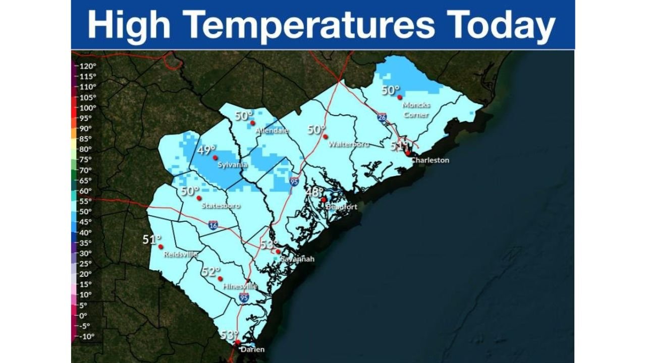
High-temperature guidance for Monday shows much of the region climbing into the upper 40s and lower 50s, with localized variations depending on cloud cover and proximity to the coast.
Expected highs include:
- Charleston, SC: near 50°
- Savannah, GA: around 52°
- Beaufort, SC: upper 40s
- Inland South Carolina counties: mid to upper 40s
While these readings represent an improvement from early-morning lows, they remain cooler than average for this time of year.
Cold Front Keeps Temperatures Below Normal Through Tuesday
Meteorologists emphasize that the warming trend will be short-lived. A strong cold front passing through the Southeast will reinforce cooler air across both South Carolina and coastal Georgia.
As a result:
- Daytime highs Tuesday will struggle to rise significantly
- Overnight lows will remain chilly
- Any sustained warmth will be delayed until later in the week
This pattern reflects a broader setup of cold air advection following the frontal passage, preventing temperatures from rebounding quickly.
Clear Skies, Dry Air Dominate the Pattern
Despite the cooler conditions, the weather will remain quiet and dry. High pressure building in behind the cold front will support:
- Mostly sunny skies
- Low humidity
- No precipitation concerns through Tuesday
These conditions may feel crisp, especially during morning hours, but travel and outdoor impacts are expected to remain minimal.
What Residents Should Expect Next
Forecasters advise residents to:
- Dress for cool mornings and mild afternoons
- Expect limited temperature recovery until midweek
- Monitor updates if colder air lingers longer than expected
While no hazardous weather is currently forecast, the persistence of cooler-than-normal temperatures may catch some off guard after recent milder periods.