
Georgia, Tennessee, North Carolina and Texas Face Major Snow-Ice Split as Widespread Winter Storm Targets Multiple States This Weekend
GEORGIA — A large and complex winter storm is increasingly likely to impact a wide swath of the country this weekend, with snow, sleet, and freezing rain stretching more than 2,000 miles from the Southwest through the Southern Plains and into the Southeast and Mid-Atlantic.
Forecast confidence is growing that this will be a high-impact, multi-state winter weather event, though exact precipitation types and placement are still being refined as the system remains several days away.
Snow Expected in the Southern Appalachians and Mid-South
Current projections show significant snowfall potential across higher elevations and colder inland areas, particularly in:
- North Georgia mountains
- Eastern Tennessee
- Western and central North Carolina
- Parts of Kentucky, Missouri, Kansas, and Oklahoma
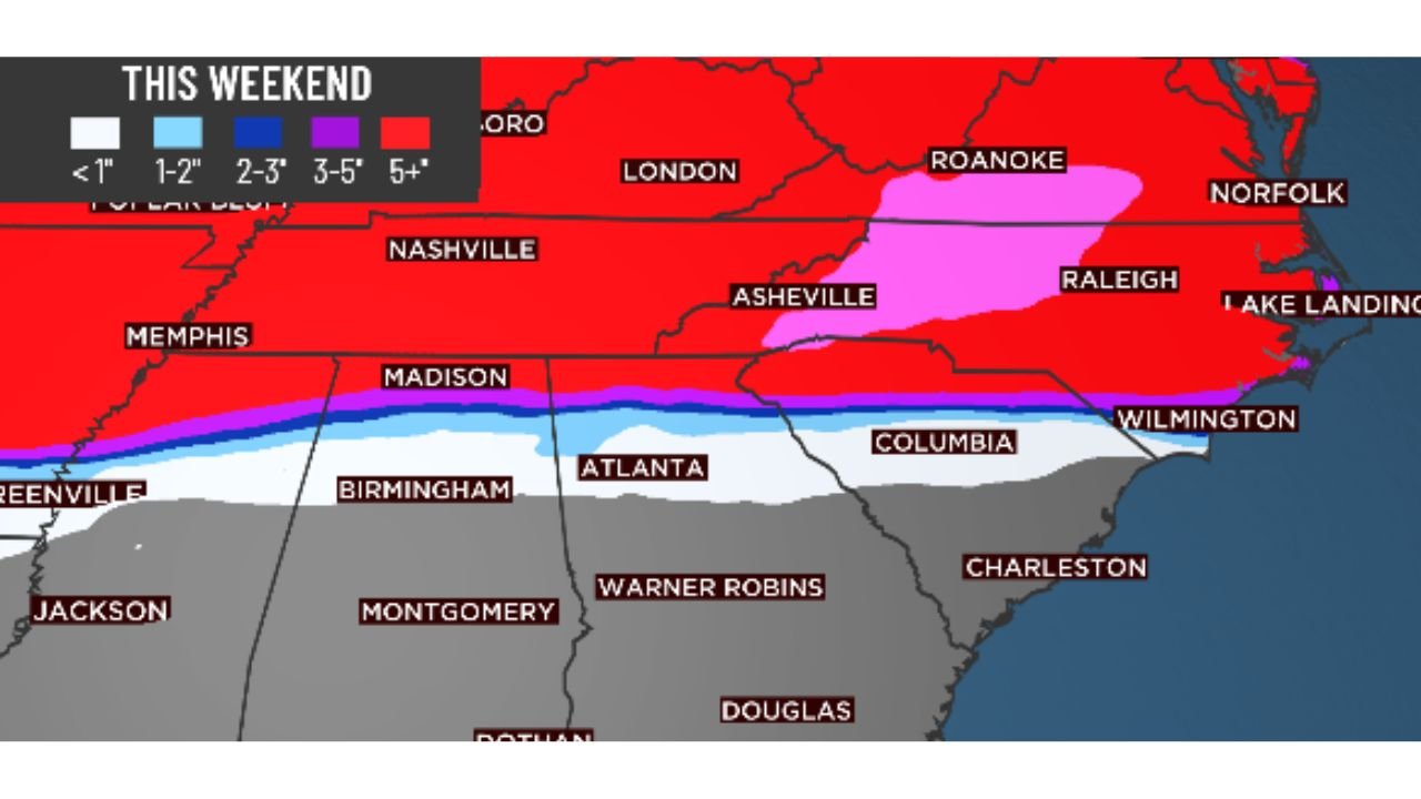
Snow totals of 6 inches or more are possible in favored mountain locations, with lighter accumulations extending into surrounding valleys and metro areas depending on temperature profiles.
Cities such as Oklahoma City, Tulsa, Wichita, Kansas City, St. Louis, Nashville, Charlotte, Raleigh, and Virginia Beach all currently show snow potential early Sunday, though totals will depend heavily on storm track and thermal boundaries.
Ice Threat Likely Across Georgia, Alabama, Mississippi and the Carolinas
While snow will dominate farther north and at higher elevations, freezing rain and sleet are a major concern across the Deep South, including:
- Metro Atlanta
- Central and southern Georgia
- Alabama
- Mississippi
- South Carolina
- Eastern Tennessee valleys
Forecast guidance highlights a significant ice risk, with some areas showing a 50–70% probability of exceeding 0.25 inches of ice, enough to cause hazardous travel, power outages, and tree damage.
With surface temperatures expected to remain very cold, ice accretion is likely to stick, increasing the risk of long-lasting impacts.
Winter Weather Could Affect More Than 150 Million People
Meteorologists estimate that around 160 million people could experience some form of wintry precipitation at the same time, ranging from snow in the Plains and Midwest to sleet and freezing rain across the South and Southeast.
The storm is expected to evolve rapidly, and small shifts in temperature or track could dramatically change local impacts—especially along the snow-to-ice transition zone.
Forecast Uncertainty Still Exists, But Impacts Look Likely
Because the system is still 4–5 days away, confidence is higher in widespread impact than in exact precipitation types for specific cities. Residents are urged not to focus solely on snowfall totals, as ice may prove more disruptive than snow in many southern locations.
Additional updates are expected as higher-resolution data becomes available later in the week.
Stay Prepared and Stay Updated
This storm has the potential to disrupt travel, utilities, and daily routines across multiple states. Continue monitoring trusted forecasts, review winter safety plans, and prepare now for rapidly changing conditions.
For continuous updates, detailed breakdowns, and local impact analysis, follow Waldron News and check back often as this developing winter storm approaches.