
Tennessee, Kentucky, Virginia, North Carolina, Georgia and Maryland Face Potential High-Impact Winter Storm With Heavy Snow, Ice, and Near-Record Cold
VIRGINIA — A powerful winter storm is increasingly coming into focus for late Saturday through Monday, with multiple weather models pointing toward heavy snow, dangerous ice accumulation, and extremely cold temperatures across a large portion of the Southeast, Ohio Valley, and Mid-Atlantic.
Forecast guidance now shows a tight but intense band of snowfall, with sharp transitions to ice and rain just miles away. This setup raises the risk for major travel disruptions, power outages, and rapidly changing conditions, especially along and near the I-40 corridor.
Snowfall Totals Could Be Significant, Especially Across Tennessee
Latest model output suggests a large swath of 6–12 inches of snow, with localized totals exceeding 12 inches possible where bands set up for extended periods.
Middle and western Tennessee stand out as a high-confidence snow zone, with Nashville directly in the corridor that could see a rare, high-impact snowstorm. Historical context underscores the potential severity — Nashville has only recorded 10 inches or more of snow seven times in recorded history, with the most recent occurrence in February 1979.
Given current trends, forecasters say this event has the potential to rank among the top 10 snowstorms ever recorded in the region, depending on final track and temperature profiles.
A Razor-Sharp Snow Cutoff Will Separate Heavy Snow From Almost Nothing
One of the most critical elements of this forecast is the extremely sharp northern edge of snowfall. Data shows a scenario where 12 inches or more of snow could drop off to little or no accumulation within a 1–2 hour drive.
Areas such as southern Missouri, western Kentucky, and southern Indiana sit near this cutoff zone. Some model runs bring these locations into heavy snow, while others leave them nearly dry. This sharp gradient is being driven by a strong arctic air mass pressing south, which can shift storm tracks quickly and dramatically.
Because of this, confidence remains lower near the northern fringe, while confidence is notably higher farther south.
Ice Storm Threat Grows Across Georgia and the Deep South
While snow dominates farther north, ice becomes the main concern across parts of Georgia and the Deep South, including metro Atlanta. Several model solutions indicate significant freezing rain and sleet, which could lead to tree damage, hazardous roads, and scattered power outages.
Ice storms often cause more long-lasting impacts than snow, and even small changes in temperature could dramatically worsen conditions. Residents in ice-prone areas should prepare for extended travel disruptions and possible infrastructure impacts.
Timing: Late Saturday Start, All-Day Sunday Impacts, Ending Monday
Current timing consensus shows precipitation developing late Saturday, intensifying overnight, and continuing through much of Sunday, with lingering impacts into Monday.
This extended duration increases the risk for compounding impacts, especially where snow or ice continues to fall while temperatures remain dangerously cold.
Brutal Cold Expected, With Temperatures Near 10°F in Some Areas
Temperatures during the storm will be exceptionally cold, with single digits and near-10°F readings possible across portions of the Mid-Atlantic and interior Northeast. Even southern Maryland could see temperatures in the teens, an unusually cold setup for heavy precipitation events.
These cold temperatures support higher snow ratios and increase the risk of icy road conditions lingering long after snowfall ends.
Model Agreement Improving, But Final Details Still Not Locked
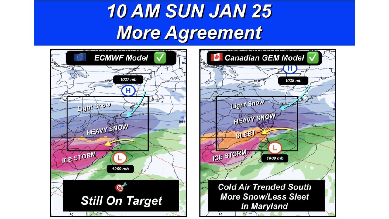
Both the European (ECMWF) and Canadian (GEM) models are now showing better agreement on timing and general placement, lending credibility to the overall storm setup. However, forecasters caution that models can still trend north or south, especially with strong arctic air involved.
Totals are intentionally being withheld for now, as even small track shifts could drastically change local outcomes. Confidence is highest in a major winter storm occurring, but exact snowfall and ice amounts will be refined over the next 24–48 hours.
What Residents Should Do Now
Residents across the impacted states should begin winter storm preparations immediately, including checking emergency supplies, planning for travel disruptions, and staying alert for forecast updates.
This system has the potential to become the region’s most impactful winter storm in a decade, especially if current trends continue.
Stay with Waldron News for continuous updates, refined snowfall projections, and real-time impacts as this high-stakes winter storm approaches. Share your local conditions and stay prepared — the next forecast update could make all the difference.