
Oklahoma, Arkansas, Tennessee, North Carolina, and Virginia Face Potential Once-in-a-Generation Winter Storm With Snow, Ice, and Dangerous Cold
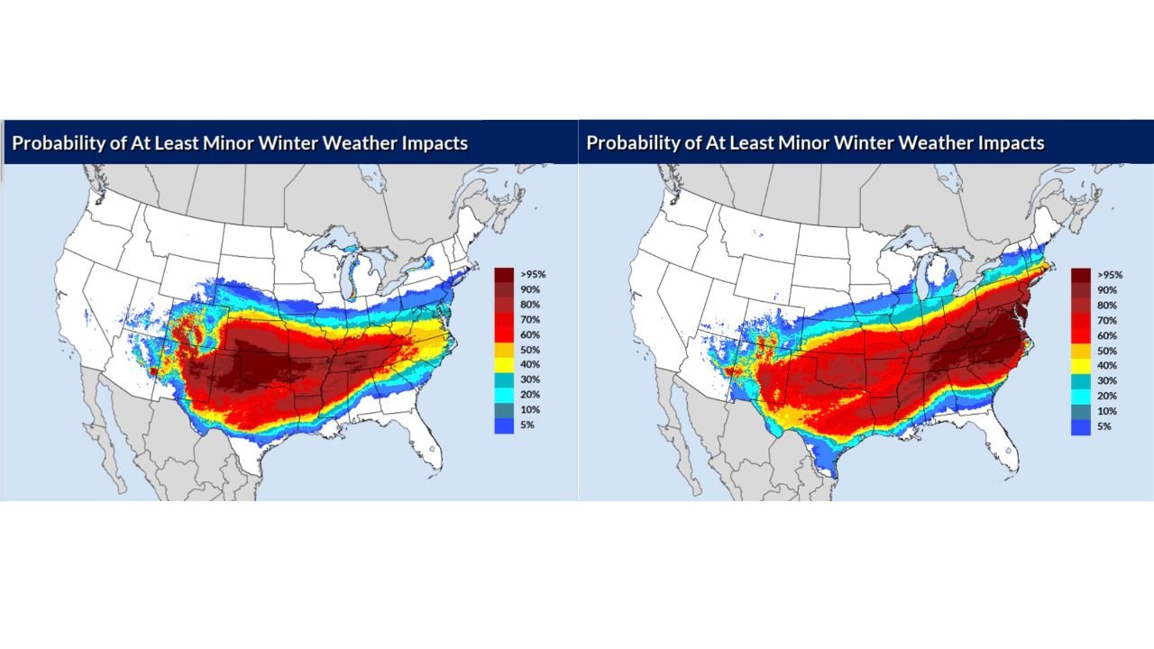
UNITED STATES — A powerful and unusually high-confidence winter storm is coming into focus across a broad swath of the country, with Oklahoma and North Texas facing the highest impacts Saturday, followed by Tennessee, North Carolina, and Virginia on Sunday, according to the latest model consensus and winter storm impact probabilities.
Meteorologists are now describing this system as one of the strongest winter storm signals seen in decades, with impact probabilities climbing into the 90–95% range across multiple states — an exceptionally rare threshold for events still several days out.
Why This Storm Is Raising Alarms Nationwide
New national winter weather impact maps show a large, continuous corridor of high-confidence impacts stretching from the southern Plains through the Mid-South and into the Mid-Atlantic. These probabilities are not simply for snowflakes in the air — they indicate travel disruptions, power outages, dangerous road conditions, and life-threatening cold.
Forecasters note that it has been decades since models have aligned this strongly for a major winter storm across so many states at once.
Saturday: Oklahoma and North Texas at Ground Zero
The first major impacts are expected Saturday, when Oklahoma and North Texas see winter storm probabilities surge into the 90–95% range.
Current guidance suggests:
- Heavy snow bands developing rapidly
- Ice storm potential on the southern edge
- Travel becoming hazardous or impossible in some areas
- Power outages possible where ice accumulates
Cold air will already be firmly entrenched, meaning snow ratios could be high and any ice that forms will be slow to melt.
Sunday: Tennessee, the Carolinas, and Virginia Take the Hit
By Sunday, the core of the storm shifts east, targeting Tennessee, North Carolina, and Virginia, where probabilities for impactful winter weather again reach 90–95%.
Tennessee Could See Historic Snowfall
Model guidance highlights middle and western Tennessee, including the I-40 corridor, as a zone of major concern. Some solutions show:
- Widespread 6–12 inches of snow
- Localized bands exceeding 12 inches
- A sharp “razor-edge” cutoff, where heavy snow drops to little or nothing within a short distance
Nashville, in particular, stands out. The city has only recorded 10 inches or more of snow seven times in recorded history, with the most recent major event occurring in February 1979. Based on current projections, this storm has the potential to rank among Nashville’s top 10 snowstorms of all time.
Ice Storm Threat Adds to the Danger
South of the heavy snow band, ice storm conditions are increasingly likely, especially across parts of:
- Arkansas
- Northern Mississippi
- Southern Tennessee
- Portions of the southern Appalachians
With surface temperatures near or below 10°F in some regions, any ice accumulation could lead to long-lasting power outages, especially if trees and power lines are stressed by both ice and wind.
Brutal Cold Makes the Situation Worse
This storm is being fueled by a deep Arctic air mass, with forecast temperatures:
- Near 10°F across much of the Mid-Atlantic
- Single digits or below zero in parts of the Midwest
- Teens reaching as far south as southern Maryland
Cold of this magnitude means:
- Road treatments become less effective
- Power restoration takes longer
- Frostbite and hypothermia risks increase rapidly
High Confidence — But Not a Lock Yet
While confidence is unusually high, forecasters caution that:
- Small track shifts could dramatically change who sees snow versus ice
- Models sometimes push systems too far south or too cold
- The northern edge of snowfall remains especially tricky
Even so, the European (ECMWF) and Canadian (GEM) models remain in strong agreement, reinforcing confidence that a major winter storm will occur, even if exact totals shift.
What Residents Should Do Now
With impacts likely beginning late Saturday and lasting through Sunday, residents across the affected states should:
- Finalize travel plans early
- Prepare for possible power outages
- Stock essential supplies
- Monitor official forecasts closely over the next 24–48 hours
This is shaping up to be the kind of storm people talk about for years — not just because of snow totals, but because of its size, severity, and timing across so many populated regions.
Stay with Waldron News for continuous updates, refined snowfall maps, timing changes, and safety guidance as this major winter storm continues to evolve.