
Arkansas, Tennessee, Kentucky, Virginia and North Carolina Face High-Impact Snow and Ice Storm From Friday Through Early Next Week
UNITED STATES — A significant and potentially dangerous winter storm is taking shape across parts of the Mid-South, Ohio Valley, and Mid-Atlantic, with the highest impacts expected in Arkansas, Tennessee, Kentucky, Virginia, and North Carolina from Friday through Sunday, with lingering effects possible into Monday.
Forecast guidance continues to signal a long-duration storm capable of producing heavy snow north of the system and severe ice accretion just south of the snow band, creating a high-risk setup for travel disruptions, power outages, and infrastructure damage.
Storm Setup: Cold Arctic Air Meets Pacific Moisture
This storm is being driven by a strong jet streak entering the southern United States while a powerful Arctic high pressure system presses cold air southward from the Midwest and Great Lakes.
At the same time, a surface low developing to the west is drawing deep Pacific moisture into the region. The collision of these air masses creates a classic snow-to-ice transition zone, where precipitation type becomes highly sensitive to small temperature changes.
Model guidance shows this system becoming large, slow-moving, and long-lived, increasing the risk for prolonged hazardous conditions.
Snow Potential: Northern Edge Still Uncertain but High-Impact Possible
Snow is favored north of the primary storm track, with guidance showing a band of moderate to heavy snow extending across parts of:
- Northern Arkansas
- Central and eastern Tennessee
- Kentucky
- Southern West Virginia
- Interior Virginia
The northern extent of the heaviest snow remains unresolved, and even small shifts north or south could dramatically change totals for individual communities. Where snow remains dominant through the event, significant accumulations are possible, especially from Saturday into Sunday.
Ice Threat: Dangerous Freezing Rain South of the Snow Band
Just south of the heavy snow zone, the signal for freezing rain is increasing, particularly in:
- Central and southern Arkansas
- Western and central Tennessee
- Southern Kentucky
- Southwestern and central Virginia
- Northern North Carolina
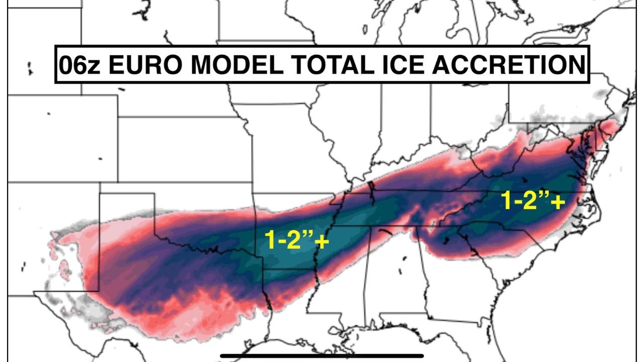
The 06z European model highlights a large swath of 1 to 2 inches or more of ice accretion, which is extremely dangerous and well beyond thresholds that typically cause tree damage and widespread power outages.
This ice threat is being driven by a strong warm nose aloft, allowing rain to fall through sub-freezing surface air and freeze on contact.
Timing: When Impacts Are Most Likely
- Friday: Light precipitation may begin in parts of Arkansas and Tennessee
- Saturday: Main storm intensifies; snow and ice rapidly expand
- Saturday Night – Sunday: Peak impacts; highest risk for heavy snow and major icing
- Monday: Lingering precipitation and slow improvement, depending on storm speed
The storm’s slow progression increases the risk of prolonged icing, which is especially dangerous for power infrastructure.
Travel, Power, and Safety Concerns
Regardless of whether your location ends up with snow or ice, impacts could be severe, including:
- Hazardous and potentially impassable roads
- Power outages lasting multiple days in ice-affected areas
- Tree damage from heavy ice loading
- Flight delays and regional travel disruptions
Residents across the impacted states should prepare now, as forecast details will continue to fluctuate.
Bottom Line
This is shaping up to be a high-impact winter storm for Arkansas, Tennessee, Kentucky, Virginia, and North Carolina, with dangerous snow and ice potential from Friday through early next week.
Uncertainty remains in exact placement, but the threat level is real, and this is not a storm to ignore. Additional updates are expected as models refine the storm track and precipitation types.
Stay weather-aware and be prepared for rapidly changing conditions.