
Texas, Oklahoma, Arkansas, Missouri, Kentucky, Tennessee, West Virginia, Virginia, Pennsylvania, New York, and New England States Brace for a Widespread Winter Storm as Historic Snow Potential Fades but Ice Threat Grows
UNITED STATES — A large and complex winter storm is still expected to impact a significant portion of the southern, central, and eastern United States this weekend, but updated guidance shows the system trending away from a historic snowfall scenario and toward a more typical — though still high-impact — winter storm setup. While heavy snow remains likely in a broad corridor, forecasters are increasingly focused on the potential for a significant ice storm, which may ultimately become the defining hazard.
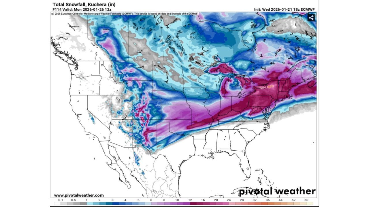
Storm Trend Shifts Away From Historic Snowfall
Earlier model runs suggested a higher-end, potentially historic snowfall across parts of the eastern United States. However, the latest 18z European (ECMWF) guidance shows the storm settling into a more familiar pattern for mid-winter, particularly for the interior Northeast where 12 to 18 inches of snow occurs fairly regularly in strong winter systems.
This shift does not eliminate impacts but reframes expectations. Areas highlighted in the snow “bullseye” tend to experience a major winter storm every few years, rather than once-in-a-generation events.
Widespread Snow Still Expected Across a Long Corridor
Despite the downgrade in historic potential, the storm remains very large in scale. Snow is forecast to stretch from parts of the Southern Plains through the Ohio Valley and into the Mid-Atlantic and Northeast, forming a long, continuous band of accumulating snowfall.
Model data continues to show high probabilities for at least 6 inches of snow across several states, including Oklahoma, Arkansas, Missouri, Kentucky, Tennessee, West Virginia, Virginia, Pennsylvania, New York, and interior New England. These probabilities indicate a high likelihood of impactful snowfall, even if totals fall short of extreme benchmarks.
Ice Storm Potential Emerging as the Main Story
While snow totals are drawing attention, the ice storm threat is becoming increasingly concerning. Forecast guidance suggests that wherever freezing rain sets up, impacts could quickly rival or exceed those from snow alone.
Ice storms are particularly dangerous due to their ability to:
- Accumulate rapidly on roads, bridges, and power lines
- Bring down trees and utility infrastructure
- Cause prolonged power outages
- Make travel nearly impossible, even with relatively low precipitation amounts
If the storm’s track does not shift farther south, forecasters expect the ice component to dominate headlines, especially across parts of the South, lower Midwest, and southern Appalachians.
Peak Impact Expected Late Saturday Into Sunday
The storm is expected to expand rapidly late Saturday and reach maximum coverage early Sunday morning, when snow, sleet, and freezing rain may be occurring simultaneously across a massive portion of the country.
At peak coverage, winter precipitation could affect well over half of the contiguous United States, increasing the likelihood of widespread travel disruptions and emergency response challenges.
What This Means Going Forward
While this storm may no longer qualify as historic in terms of snowfall, it remains high-impact and potentially dangerous, particularly if ice accumulations verify as forecast. Small shifts in temperature or storm track over the next 24 to 36 hours could significantly change who sees snow versus ice, making close monitoring critical.
Bottom Line
This weekend’s winter storm is evolving from a potential record-breaker into a classic but dangerous multi-hazard event, with snow still likely across a broad region and ice posing the greatest threat. Residents across the affected states should prepare for rapidly changing conditions, difficult travel, and possible power disruptions.
Stay with Waldron for continued updates as newer model data refines snowfall totals, ice placement, and timing.