
Maryland, Virginia, and Washington, D.C. Placed Under a Rare High Winter Storm Threat as Significant Snow, Ice, and Long-Lasting Impacts Loom
UNITED STATES — A rare HIGH Winter Storm Threat has been issued for the District of Columbia, central and northern Virginia, and much of Maryland, marking the first time since 2016 that this level of winter storm confidence has been assigned to the region. Forecast confidence is high that this storm will bring major travel disruptions, widespread closures, and lingering impacts that could last well into next week.
Officials are urging residents across the DMV to complete all preparations by Saturday morning, as conditions are expected to deteriorate rapidly once precipitation begins.
Why This Winter Storm Threat Is Unusual for the DMV
High-level winter storm threats are rarely issued for the Washington–Baltimore region due to the area’s typically marginal winter temperatures. The issuance of this alert signals strong confidence in both impactful precipitation and cold air availability, increasing the likelihood of disruptive snow and ice.
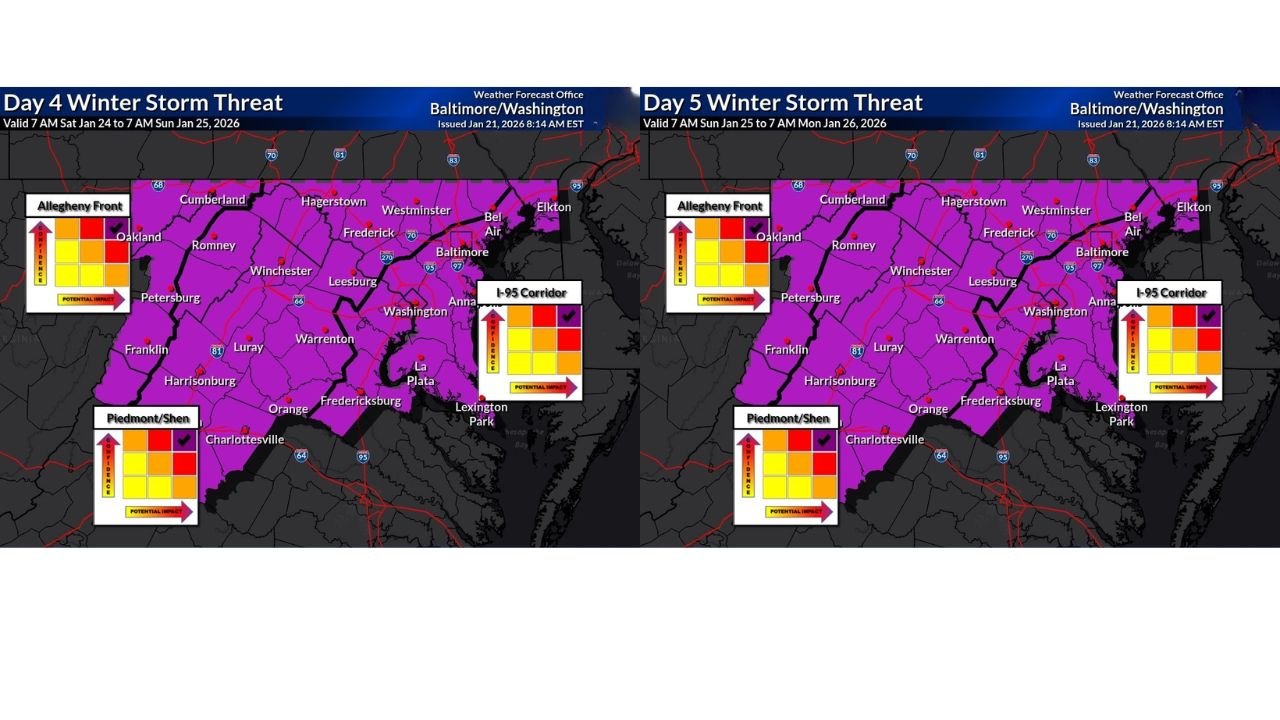
According to forecast guidance, this system has a higher probability than typical DMV winter storms of producing widespread and significant impacts, rather than localized or short-lived disruptions.
Significant Travel Delays and Closures Expected
Confidence is growing that roadways, public transit, and air travel across the I-95 corridor, including Washington, Baltimore, Frederick, Leesburg, Annapolis, and surrounding suburbs, will be heavily impacted.
Nighttime and early morning travel windows appear especially hazardous, with snow and ice accumulation expected to occur while surface temperatures remain well below freezing.
Impacts Could Linger Into Next Week Due to Cold Temperatures
One of the most concerning aspects of this storm is the cold pattern expected to follow it. Forecasts indicate temperatures remaining low enough next week to slow melting, allowing snow and ice to persist on roads, sidewalks, and untreated surfaces.
This raises the risk of:
- Prolonged school and government closures
- Extended travel hazards
- Delayed cleanup operations
- Refreezing at night even after precipitation ends
Still Uncertainty in Exact Snow and Ice Totals
While confidence is high in significant impacts, forecasters caution that exact snowfall and ice amounts are still uncertain. Small shifts in storm track or temperature profiles could determine whether certain locations see more snow versus more ice.
Regardless of exact totals, the overall impact level is expected to be high across the region.
Key Preparation Timeline
Residents should aim to complete storm preparations by Saturday morning, including:
- Adjusting travel plans
- Stocking essentials
- Charging devices
- Securing vehicles and property
- Preparing for possible extended disruptions
Bottom Line
This is shaping up to be one of the most significant winter storm threats the DMV has faced in nearly a decade. The combination of high confidence, widespread impacts, and lingering cold makes this event especially disruptive compared to typical winter weather in the region.
Residents across Maryland, Virginia, and Washington, D.C. should closely monitor updates and be prepared for dangerous travel conditions and prolonged impacts. Stay with Waldron for continued updates as this winter storm evolves.