
Ohio, Pennsylvania, West Virginia, Virginia, Maryland, and New York Face a Narrowing Winter Storm Forecast as Heavier Snow Axis Sharpens for the Weekend
United States — As the calendar moves closer to the weekend, forecast confidence is increasing across the Ohio Valley, Mid-Atlantic, and interior Northeast, where a significant winter storm is expected to develop. While uncertainty remains in exact snowfall placement, meteorologists note that the range of possible outcomes is shrinking, allowing a clearer picture of where heavier versus lighter snow is most likely to fall.
This refinement is typical as an event approaches, particularly for large, synoptic winter storms where small shifts in storm track can dramatically alter local snowfall totals.
Why the Forecast Is Becoming Clearer Now
Earlier in the week, long-range guidance supported multiple plausible outcomes. As newer data arrives, models are beginning to converge, reducing the number of viable scenarios. This does not eliminate uncertainty, but it improves confidence in the overall structure of the storm, especially the location of the heaviest snow band.
The key takeaway is not exact totals yet, but where the storm’s core dynamics are most likely to align.
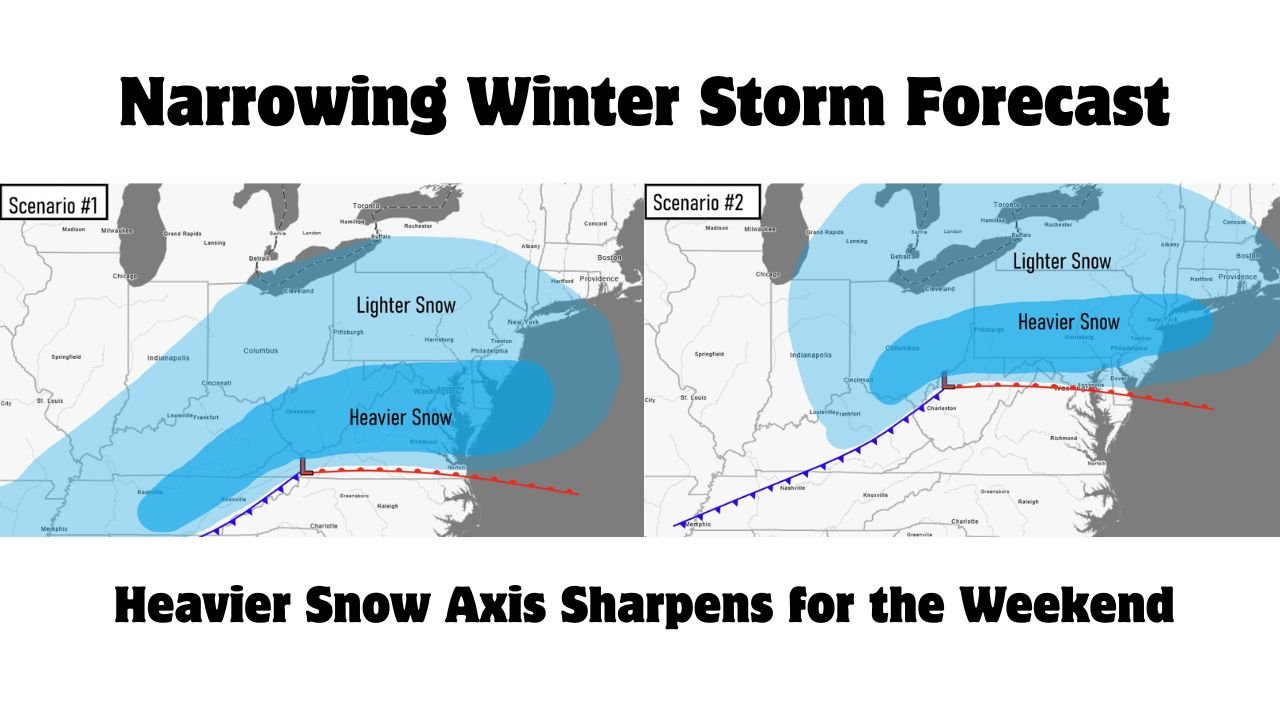
Scenario One: Heavier Snow Presses Farther South
In the first scenario, the storm’s surface low tracks slightly farther south, allowing colder air to dominate a broader area. In this case, heavier snow would extend deeper into parts of West Virginia, Virginia, and Maryland, with lighter snow reaching northward into Ohio and Pennsylvania.
This setup favors a more impactful outcome for the Mid-Atlantic, particularly near and just north of the rain–snow boundary.
Scenario Two: Heavier Snow Shifts Northward
The second scenario places the storm track slightly farther north, shifting the heaviest snowfall axis into Pennsylvania, New York, and portions of the interior Northeast, while areas farther south see comparatively lighter accumulations.
Even in this outcome, snow would still be widespread, but the most disruptive totals would be concentrated farther north, closer to the core of the cold air and strongest lift.
Probability Data Supports a High-Impact Event
Snow probability maps show moderate to high chances of exceeding 6 inches across much of central and eastern Ohio, western and central Pennsylvania, West Virginia, and adjacent areas. Several locations fall within probability ranges exceeding 60 to 80 percent, indicating strong model agreement that impactful snowfall is likely somewhere within this corridor.
This reinforces confidence that the event itself is not in doubt — only the precise placement of the heaviest band.
What This Means for the Region
For residents across the affected states, the message is consistency rather than precision. While snowfall totals may still adjust, travel disruptions, hazardous road conditions, and operational impacts are increasingly likely, particularly from Saturday night through Monday.
As the storm draws closer, additional refinements will focus on local snowfall ranges, rather than broad scenario shifts.
Bottom Line
The winter storm forecast for this weekend is entering its most critical refinement phase. Across Ohio, Pennsylvania, West Virginia, Virginia, Maryland, and New York, confidence is growing that a significant snow event will occur, even as forecasters continue to fine-tune where the heaviest snow will fall.
Residents should prepare for widespread winter travel impacts and stay alert for updates as final snowfall corridors are locked in. Stay with Waldron for continued coverage as this forecast becomes more precise.