
Appalachians, Ohio Valley, and Eastern United States Turn Sharply Colder as Arctic Air Spills Back East Behind Strong High Pressure
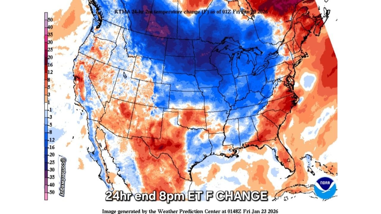
UNITED STATES — A brief break from winter chill is coming to an abrupt end as cold Arctic air surges back across the Appalachians, spreading rapidly into the Ohio Valley, Mid-Atlantic, and much of the Eastern United States. New temperature-change analysis shows widespread 24-hour drops of 10 to 30 degrees, driven by a strong Arctic high pressure system forcing colder air south and east.
Cold Air Reclaims the Appalachians
The latest temperature-change maps highlight a pronounced blue swath expanding from the Midwest into the Appalachians, confirming that colder air is not just arriving—but locking back in.
Behind a departing system, Arctic high pressure is pressing eastward, pushing cold air through mountain gaps and valleys. This pattern favors cold air damming, allowing chilly air to spill downslope and spread efficiently into lower elevations.
How Sharp the Temperature Drop Is
The data shows a dramatic reversal from recent milder conditions:
- Appalachians: 15–25°F colder in just 24 hours
- Ohio Valley: 10–20°F temperature drop
- Mid-Atlantic and interior Southeast: 10–15°F colder
- Northeast: Cold air re-establishing after a short-lived warm-up
These are not gradual changes—this is a fast, forceful return to winter.
Why This Cold Surge Is So Effective
This cold push is being driven by:
- Strong Arctic high pressure advancing from the central U.S.
- North-to-northwest flow funneling cold air directly east
- Terrain effects in the Appalachians, accelerating cold-air drainage
- Lack of solar recovery, allowing cold air to dominate day and night
Once established, this type of pattern is difficult to dislodge quickly.
What Residents Will Notice
As colder air settles back in, impacts will include:
- Much colder mornings, especially east of the mountains
- Daytime temperatures struggling to rebound
- Increased wind chill, making it feel colder than actual readings
- Renewed freeze risk, even in areas that briefly thawed
The contrast will be especially noticeable in communities that experienced a short-lived warm spell.
Looking Ahead
Forecast confidence is high that this colder regime holds through the near term, with Arctic high pressure maintaining control across the eastern half of the country. Any moderation will likely be slow and limited, especially across the Appalachians and surrounding regions.
For now, winter is firmly back in charge across the East after a deceptive pause.
Waldron will continue tracking temperature trends and provide updates as this cold air mass settles in and evolves over the coming days.