
Tennessee Ice Storm Leaves Widespread Half-Inch to One-Inch Ice Accumulations From West Tennessee Through Middle Tennessee Into East Tennessee
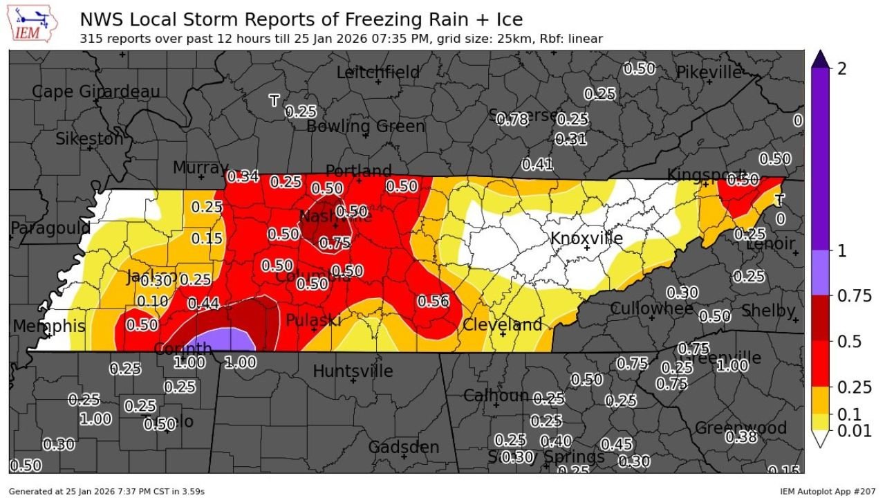
UNITED STATES — A significant ice storm has left a dangerous glaze of freezing rain and ice across much of Tennessee, with new National Weather Service Local Storm Reports confirming widespread ice accumulations ranging from 0.25 to 0.75 inches, and localized totals near or exceeding 1 inch in parts of the state.
The hardest-hit corridor stretches from West Tennessee through Middle Tennessee and into portions of East Tennessee, creating hazardous travel conditions, power outage risks, and long-lasting impacts well beyond the end of precipitation.
Hardest-Hit Areas and Ice Totals
According to compiled storm reports over the past 12 hours, the most severe icing occurred across Middle Tennessee, including:
- Nashville metro and surrounding counties:
Widespread 0.50 to 0.75 inches of ice, with some localized higher reports - Southern Middle Tennessee (Pulaski area):
Ice totals around 0.50 to 0.56 inches - West Tennessee into southwest Middle Tennessee:
General 0.25 to 0.50 inches, with isolated heavier pockets - Upper Cumberland and East Tennessee fringe:
Mostly 0.25 inches, tapering lower farther east
In far southern Tennessee near the Alabama border, isolated reports approached 1 inch of ice, particularly where freezing rain persisted longest.
Why This Ice Event Was So Impactful
Unlike quick-hitting ice events, this storm featured prolonged freezing rain, allowing ice to steadily accumulate on:
- Power lines
- Trees and limbs
- Roadways and bridges
Ice amounts above 0.25 inches are typically enough to cause scattered power issues. Once totals exceed 0.50 inches, the risk for widespread outages and tree damage increases dramatically — a threshold many Tennessee communities reached.
Travel and Infrastructure Impacts
Road conditions remain extremely dangerous, especially on:
- Untreated secondary roads
- Elevated surfaces such as bridges and overpasses
- Hills and shaded areas
Even where crews have applied treatment, refreezing temperatures will continue to lock ice in place overnight, prolonging hazardous conditions.
What Happens Next
While freezing rain has ended in many areas, impacts will linger:
- Ice will melt slowly due to cold daytime temperatures
- Falling branches and power lines remain a risk
- Cleanup and restoration efforts may take multiple days in the hardest-hit zones
Any additional precipitation, even light snow or drizzle, could worsen conditions if surface temperatures remain below freezing.
Bottom Line
This was a high-impact Tennessee ice storm, with half-inch to locally one-inch ice totals causing serious travel and infrastructure concerns across much of the state. Residents are urged to avoid unnecessary travel, remain cautious of falling debris, and prepare for prolonged disruptions.
If you’re experiencing outages, road closures, or damage in your area, share your local conditions and stay with WaldronNews.com for continued winter storm coverage and recovery updates.