
Light Snow and Slick Travel Expected Across Washington DC, Maryland, and Northern Virginia as Weak Clipper Moves Through Tonight
UNITED STATES — A weak Alberta clipper system is tracking south of the Mid-Atlantic tonight into early Wednesday morning, bringing a light snow event and slick travel conditions to the Washington DC metro area, northern Virginia, and much of Maryland, according to regional forecast data.
The system carries limited moisture, keeping snowfall amounts low overall, but brief heavier snow bands could still create localized travel issues during the overnight and early morning hours.
Light Snow Spreads Across the DMV Overnight
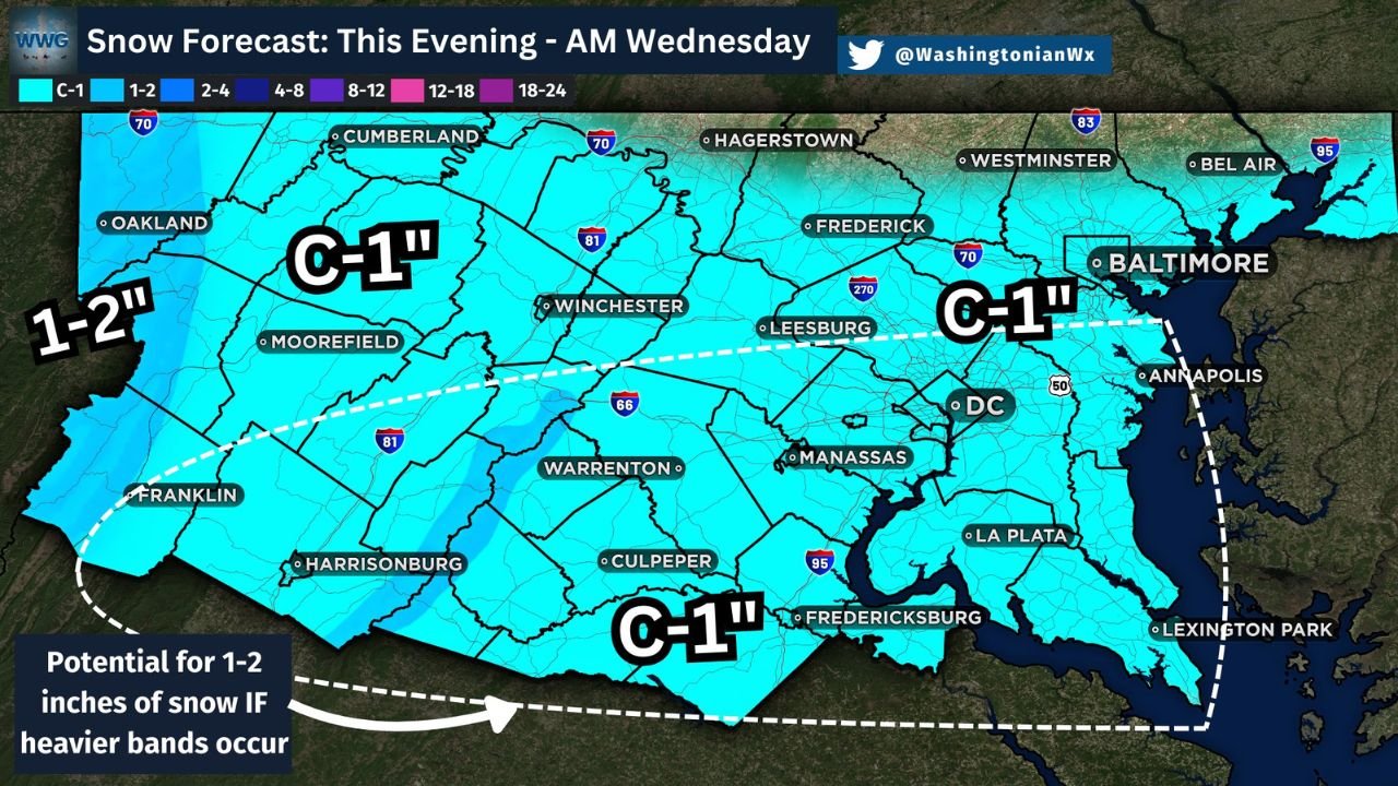
Snow is expected to overspread the region this evening, continuing into Wednesday morning as the clipper slides east. Most areas across Washington DC, suburban Maryland, and northern Virginia are forecast to receive a coating to around one inch of snow, with the highest confidence in light accumulations.
Forecast guidance shows the core of the system remaining moisture-starved, which will limit widespread heavier snowfall. However, snowfall intensity could briefly increase if narrow bands develop along the southern edge of the system.
Localized 1–2 Inch Totals Possible if Bands Develop
While most locations are expected to stay under one inch, parts of western Maryland, northern Virginia, and areas south of the DC metro could see localized totals near 1–2 inches if heavier snow bands briefly set up.
These bands would be short-lived, but even minor increases in snowfall rates could lead to quick accumulation on untreated roads, especially during the overnight hours.
Slick Travel Likely Despite Low Snow Totals
Even with modest snowfall, slick and icy travel conditions are expected across the region. Road temperatures may drop enough overnight for snow to accumulate on bridges, overpasses, and secondary roads.
Drivers should use caution during the late evening, overnight, and early Wednesday morning commute, particularly in areas where snowfall briefly becomes more intense.
Snow Tapers Early Wednesday Morning
Snow showers are expected to taper off from west to east by Wednesday morning as the clipper exits the region. No significant additional accumulation is expected after sunrise, but lingering slick spots could remain into the early commute.
No major disruptions are anticipated, but the event serves as another reminder that even weak systems can create short-term hazards during winter travel.
Stay weather-aware and drive cautiously tonight. For continued Mid-Atlantic weather updates, forecasts, and impact analysis, follow WaldronNews.com and share how conditions look in your area.