
Arctic Front Signals Raise Risk of Plowable Snow Across New England as February 7–8 System Takes Shape
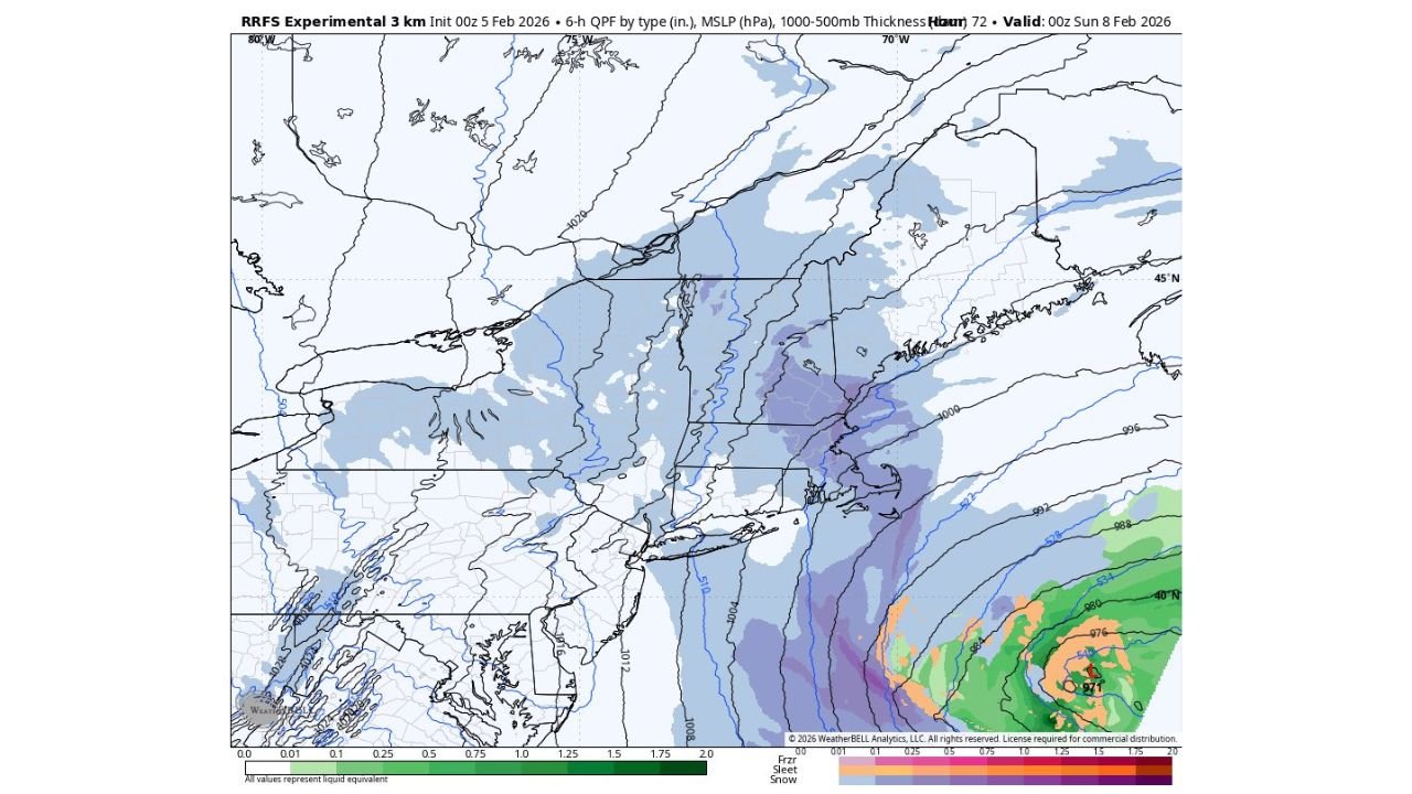
UNITED STATES — Weather models are beginning to converge on a developing winter setup across New England as an Arctic front pushes into the Northeast on Saturday, February 7, bringing the potential for light to locally plowable snowfall in parts of the region, according to early guidance.
While confidence remains limited at this range, multiple model runs are now detecting an inverted trough and weak coastal interaction, a pattern that has historically produced narrow but impactful snow bands in New England.
What the Latest Models Are Showing
Forecast guidance from ECMWF, RDPS, and experimental RRFS runs consistently depicts light-to-moderate precipitation developing along and east of the Arctic boundary late Saturday into early Sunday.
The most persistent signals currently favor:
- Eastern Massachusetts
- Rhode Island
- Coastal and eastern Connecticut
- Southern New Hampshire
- Interior and coastal Maine
Several simulations show enhanced snowfall rates within narrow corridors, suggesting that while totals may remain light overall, localized plowable snowfall cannot be ruled out, especially if banding becomes established.
Why Confidence Is Still Limited
Meteorologists caution that inverted trough events are notoriously difficult to pin down, especially this far out. Small shifts in:
- Arctic front placement
- Coastal low interaction
- Upper-level forcing
could significantly alter snowfall distribution.
That said, the repeat appearance of this signal across multiple model runs increases confidence that some form of wintry precipitation is likely, even if final impacts remain uncertain.
Temperature Setup Favors Snow Where Precipitation Develops
Thermal profiles across New England remain firmly cold, with model guidance showing below-freezing temperatures at the surface and aloft during the event window.
This supports snow as the dominant precipitation type, particularly inland and during nighttime hours. Coastal locations may experience lighter totals depending on wind direction and boundary placement.
What Residents Should Watch For Next
Over the coming days, forecasters will monitor:
- Whether snowfall bands consolidate or fragment
- How far west measurable snow can spread
- Potential for localized higher totals under narrow bands
Even a modest system could impact travel if snow rates briefly intensify, particularly in urban corridors and coastal communities.
Bottom Line
While this does not yet qualify as a high-confidence winter storm, the data supports continued monitoring for a potential snowfall event across New England this weekend. Any future upgrades will depend on improved agreement between short-range models.
Stay weather-aware and keep checking back with Waldronnews.com for updated forecasts, refined snowfall maps, and impact-based guidance as confidence improves.