
Mid-Atlantic Snowstorm Final Call: D.C., Maryland, Pennsylvania, New York and New Jersey Face 6 to 16+ Inches, With Isolated 26-Inch Jackpot Possible
MID-ATLANTIC — A powerful late-February winter storm is poised to bring widespread accumulating snow from Virginia and West Virginia through Maryland, Washington D.C., Pennsylvania, New Jersey, and into New York, with updated projections now increasing totals across several major metro areas.
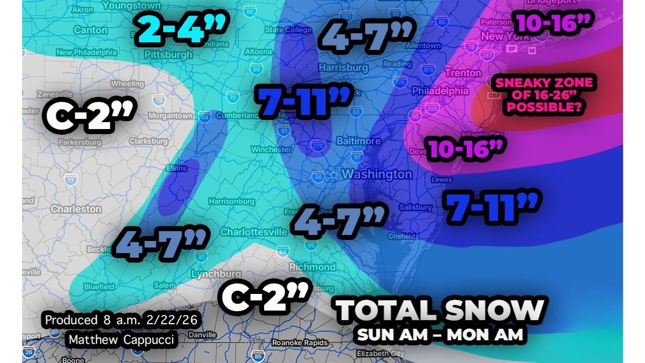
The latest forecast call shows a broader and heavier swath of snow pushing westward, placing millions of residents under the threat of significant accumulations between Sunday morning and early Monday.
Washington D.C. And Central Maryland Now In Higher Snow Zone
Forecasters have increased snowfall projections in the DMV area, with Washington D.C. proper now expected to approach or exceed 6 inches.
A wide 7 to 11 inch band stretches across:
- Central Maryland
- Much of northern and central Virginia
- Eastern West Virginia
- South-central Pennsylvania
Extreme eastern Maryland and more of the Delmarva Peninsula have also been upgraded into the 7 to 11 inch category, signaling confidence in heavier snow reaching coastal communities.
Baltimore and surrounding areas sit squarely within this higher band, meaning prolonged snowfall rates could lead to difficult travel conditions late Sunday into early Monday morning.
Central Pennsylvania Added To 7–11 Inch Contour
A notable expansion of heavier totals now includes central Pennsylvania, including areas near:
- Harrisburg
- Altoona
- State College
This increase is tied to what meteorologists describe as mid-level deformation, a zone in the atmosphere where air stretches and enhances upward motion. That lift helps increase snowfall intensity and duration, potentially allowing some communities in central Pennsylvania to reach or exceed the higher end of the 7–11 inch range.
Meanwhile, western Pennsylvania — including Pittsburgh — is forecast to see lighter totals in the 2 to 4 inch range, with some southwestern areas closer to the Ohio border potentially remaining closer to a coating to 2 inches.
10–16 Inches Now Explicitly Includes New York City And Philadelphia
One of the most significant changes in the latest forecast is the westward expansion of the 10 to 16 inch contour by roughly 30 miles.
That shift now explicitly places:
- Philadelphia
- New York City
- Portions of northern New Jersey
within the higher snowfall range.
However, both cities carry higher-than-average uncertainty.
In New York City, snowfall totals will depend heavily on where two key features align:
- The inland deformation band
- The coastal frontogenesis zone
If NYC becomes positioned beneath a persistent heavy snow band, totals could climb beyond 16 inches. But if the city ends up in a subsidence (sinking air) region between bands, accumulations could come in lower than currently projected.
Philadelphia sits in a similar situation, though confidence is growing that double-digit snowfall is increasingly likely.
New Jersey’s “Sneaky Zone” Could See 16 To 26 Inches
Perhaps the most eye-catching projection is across parts of New Jersey, where forecasters continue to highlight a potential isolated 16 to 26 inch snowfall pocket.
This would be driven by a feature known as a Norlun trough — a narrow zone of weaker low pressure and atmospheric convergence that forms northwest of the main offshore storm system.
When air converges and is forced upward in this setup, snowfall rates can intensify dramatically. If this band locks into place over one location for several hours, localized totals could far exceed surrounding areas.
The map suggests this high-end zone could affect portions of:
- Central and southern New Jersey
- Areas between Philadelphia and the New York City metro region
Exact placement will determine whether communities experience a significant storm or a potentially historic one.
Lighter Totals South And West
Farther south into southern Virginia, totals drop off sharply, with many areas seeing a coating to 2 inches.
In West Virginia’s western counties, snowfall is expected to remain lighter as well, with sharp gradients separating low and moderate accumulation zones.
This tight gradient means small shifts in storm track could cause dramatic changes in snowfall totals over short distances.
Timing And Impacts
The storm is expected to produce snowfall between Sunday morning and early Monday morning, with the heaviest bands likely occurring during peak overnight hours.
Potential impacts include:
- Hazardous travel on major interstates including I-95, I-76, I-83, and I-70
- Airport delays at D.C., Philadelphia, Newark, and New York-area hubs
- Power outages in areas where snow becomes heavy and wet
Given the dynamic banding potential, some neighborhoods could see snowfall rates high enough to overwhelm road treatment efforts for several hours.
Final Thoughts
This storm has evolved into a high-impact winter event for the Mid-Atlantic and Northeast corridor, with snowfall projections increasing across key metropolitan areas.
While confidence is growing in widespread moderate to heavy snowfall, exact totals will hinge on band placement, especially in New York City and New Jersey.
Residents across Virginia, Maryland, Washington D.C., Pennsylvania, New Jersey, and New York should prepare for significant winter weather conditions as the storm unfolds.
Stay with WaldronNews.com for continued updates as final adjustments to snowfall projections are made.