
Historic Blizzard to Bury Rhode Island and Southeast Massachusetts With Up to 40 Inches as Boston, Cape Cod and Providence Brace for Crippling Sunday–Monday Storm
SOUTHEASTERN NEW ENGLAND — A potentially historic snowstorm is unfolding across southern New England, with updated projections showing extreme snowfall totals that could rival or surpass some of the biggest snow events ever recorded in parts of Rhode Island and southeastern Massachusetts.
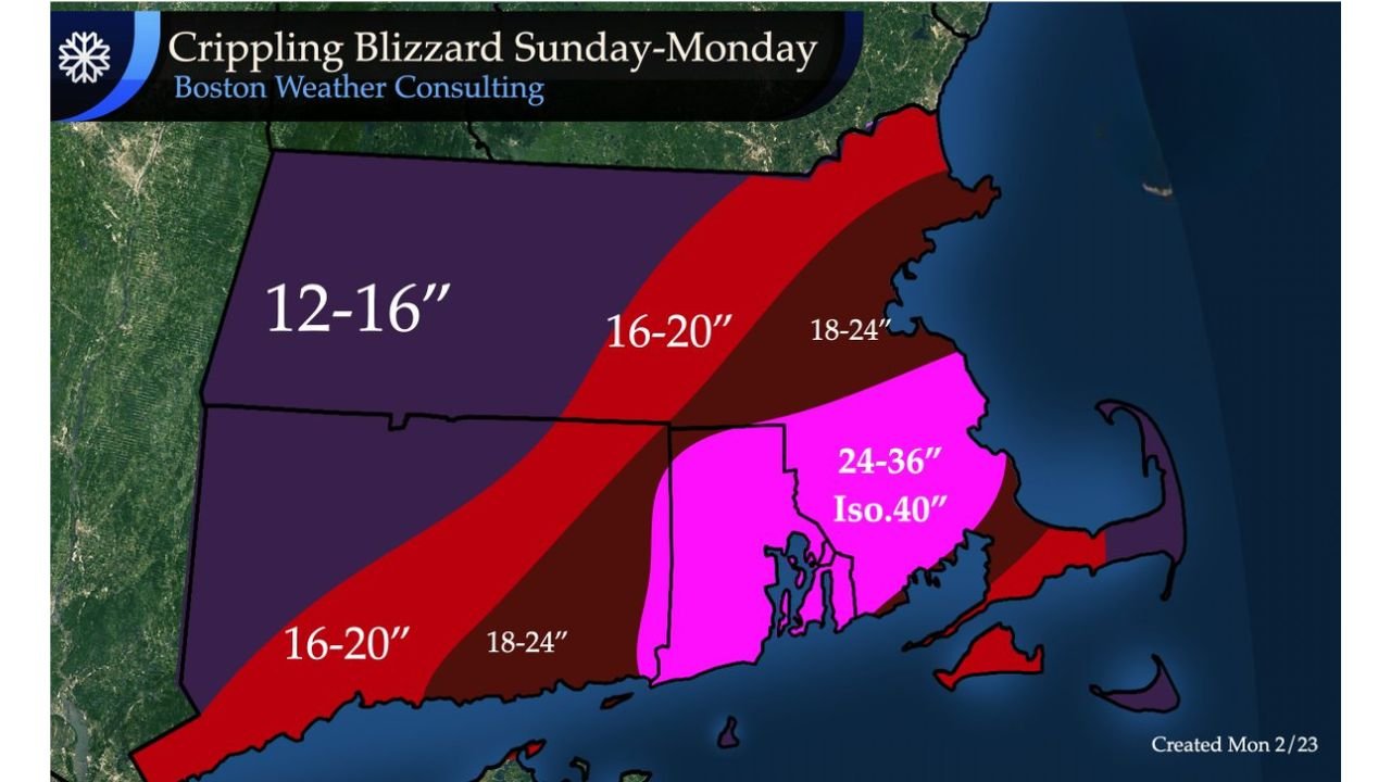
Forecasters are now calling for a crippling Sunday into Monday blizzard, with snowfall ranges that escalate dramatically from west to east — and the highest totals centered squarely over Rhode Island and adjacent southeast Massachusetts.
24 to 36 Inches, Isolated 40 Inches Possible in Rhode Island
The most alarming totals are projected across:
- Much of Rhode Island
- Bristol County, Massachusetts
- Areas surrounding Providence, Warwick, Cranston, and Fall River
Snowfall in this core zone is forecast to reach 24 to 36 inches, with isolated locations potentially approaching or exceeding 40 inches.
If those numbers verify, this storm would rival the top snowfall events ever recorded in these communities.
Boston Metro and Eastern Massachusetts: 18 to 24 Inches
Moving north and east toward:
- Boston
- Quincy
- Brockton
- Plymouth
- The South Shore
Snowfall totals are projected in the 18 to 24 inch range.
These amounts alone would classify as a major blizzard event, capable of shutting down travel, disrupting power, and causing significant infrastructure strain.
Western and Central Massachusetts: 12 to 20 Inches
Further inland across western and central Massachusetts:
- Springfield and the Pioneer Valley
- Worcester County
- Interior communities
Totals are expected to range from 12 to 16 inches in some western areas, increasing to 16 to 20 inches across central sections.
While slightly lower than coastal zones, these totals still represent a high-impact winter storm.
Cape Cod and Coastal Areas
Cape Cod is forecast to see substantial snowfall as well, though totals may vary across the peninsula.
The combination of heavy snow and strong coastal winds raises concerns about:
- Blizzard conditions
- Significant drifting
- Coastal impacts
- Near-zero visibility
A Storm That Could Make History
Meteorologists warn that snow amounts in the hardest-hit areas may rival or even exceed the region’s most notable snowstorms on record.
The concentration of extreme totals over Rhode Island and southeast Massachusetts places communities like Providence and Fall River in the potential bullseye of a once-in-years event.
Travel and Safety Concerns
With snowfall rates likely intense at times and winds increasing, officials are expected to urge residents to:
- Avoid travel during peak storm hours
- Prepare for possible power outages
- Stock essential supplies
- Stay off roads to allow emergency operations
Conditions are expected to deteriorate rapidly once the heaviest snow bands set up.
Bottom Line
Southeastern New England is facing a crippling Sunday–Monday blizzard, with 24 to 36 inches — and isolated 40 inches — possible across Rhode Island and nearby Massachusetts communities.
Boston, the South Shore, and interior Massachusetts will also see significant accumulations, with widespread totals well above a foot.
If projections hold, this storm will be remembered as one of the most intense snow events in recent history for parts of southern New England.
WaldronNews.com will continue monitoring this developing situation and provide updates as the storm progresses.