
Heavy Snow Bands Slam Southern Maryland, Delmarva and South Jersey as Coastal Storm Intensifies East of I-95
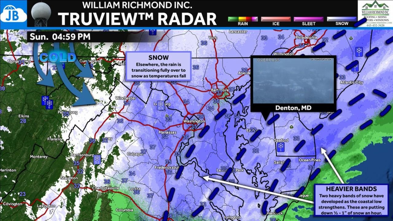
MID-ATLANTIC REGION — Snow has now taken over much of the region as temperatures fall into the lower 30s, with the last pockets of rain rapidly transitioning to all snow Sunday evening. As a strengthening coastal storm pulls northeast, intense snow bands are developing across Southern Maryland, the Delmarva Peninsula, and South Jersey — with snowfall rates reaching up to 1 inch per hour in some areas.
Forecasters say the storm remains on track, with the heaviest impacts expected east of Interstate 95 overnight.
Rain Changes to Snow as Cold Air Locks In
Earlier mixed precipitation has transitioned fully to snow across:
- Washington, D.C.
- Baltimore, Maryland
- Northern Virginia
- Central Maryland
Temperatures hovering in the low to mid 30s are allowing snow to accumulate, especially on grassy and elevated surfaces. Colder air filtering in from the west is helping flip remaining rain to snow across the Chesapeake Bay region.
Southern Maryland and Delmarva in the Bullseye
The most intense bands are currently focused across:
- Southern Maryland, including areas near Lexington Park and St. Mary’s County
- Denton and Caroline County, Maryland
- Salisbury and the lower Eastern Shore
- Southern Delaware
- Cape May and coastal South Jersey
These bands are producing snowfall rates between one-half inch and 1 inch per hour, rapidly covering roads and reducing visibility.
Radar imagery shows two dominant heavy snow corridors forming as the coastal low strengthens offshore.
Snow Focuses East of I-95 Overnight
While snow is falling across much of the Washington-Baltimore corridor, guidance indicates the most persistent and intense snowfall will remain east of I-95 through the overnight hours.
Communities along and east of:
- U.S. Route 301
- The Chesapeake Bay
- The Atlantic coastline
are expected to see the heaviest accumulations.
Travel conditions are deteriorating quickly in these zones, particularly on bridges, overpasses, and secondary roads.
Western Areas See Lighter Snow
Farther west into western Maryland and the Appalachian foothills, snowfall is lighter and more scattered, though colder air continues to filter in.
Communities near Cumberland and portions of West Virginia are seeing steady snow, but the most significant banding remains closer to the coast.
Conditions Likely to Worsen Overnight
As the coastal low deepens, snow coverage is expected to increase region-wide. Heavier bursts could shift north or south depending on storm track, but current trends support:
- Continued heavy snow across Delmarva and South Jersey
- Moderate snow in the D.C.–Baltimore corridor
- Reduced visibility during banding
Motorists are urged to use caution, especially as snowfall intensifies east of I-95.
Bottom Line
A strengthening coastal storm is now delivering heavy snow across Southern Maryland, Delmarva, and South Jersey, with snowfall rates up to 1 inch per hour in the most intense bands.
Snow will ramp up overnight and remain focused east of I-95, with deteriorating travel conditions expected through the night.
WaldronNews.com will continue tracking the storm as it develops.