
Rhode Island, New York and New Jersey Crushed by Blizzard of ’26 as North Kingstown Hits 35 Inches and Islip Logs Biggest Snow Since 1963
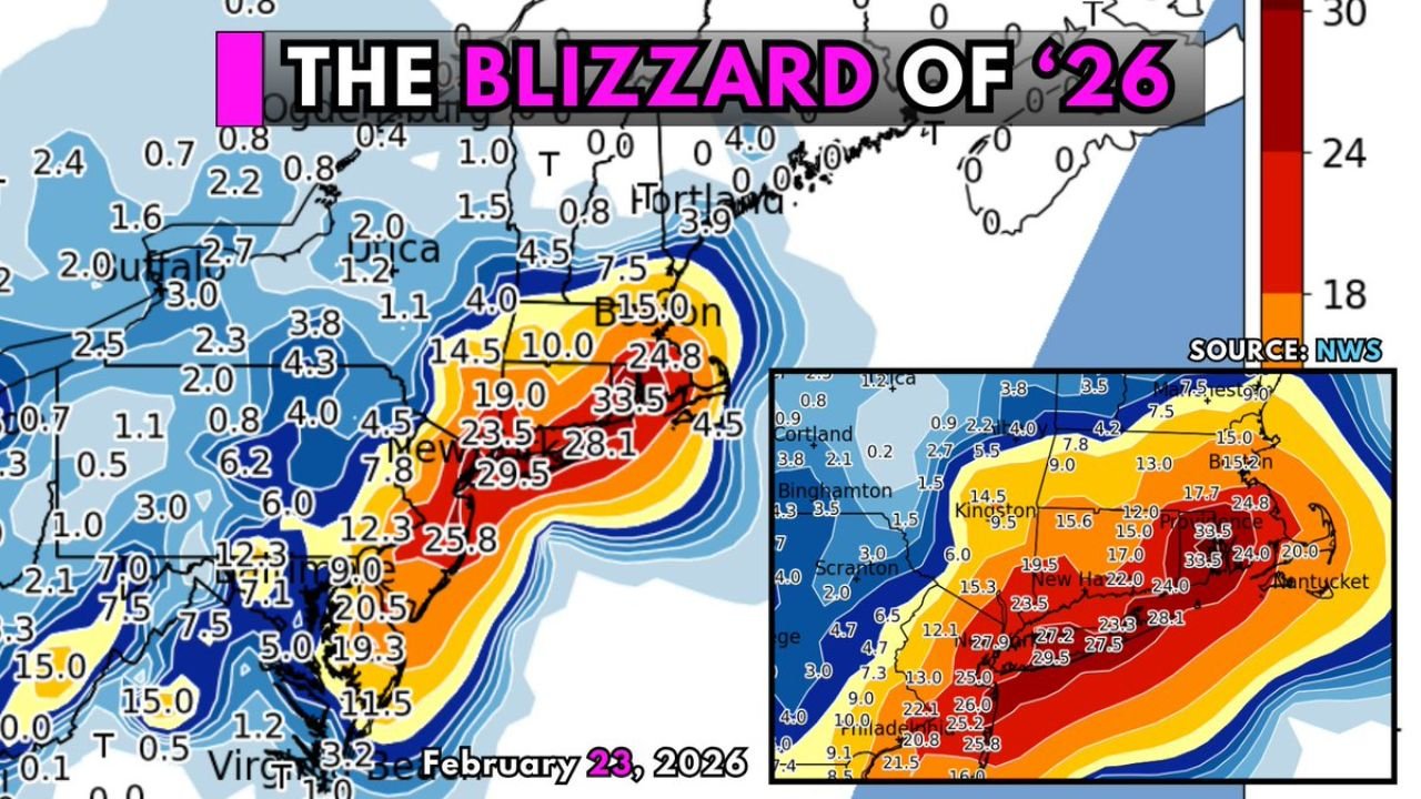
UNITED STATES — The Blizzard of ’26 has delivered staggering, record-challenging snowfall totals across parts of Rhode Island, New York, New Jersey, and Connecticut, with several communities officially buried under more than two feet of snow — and in some cases, nearly three.
As final reports continue to come in, the storm is being described as one of the most intense East Coast snow events in decades.
Rhode Island: 30+ Inches and the Clear Winner
The biggest totals have come out of Rhode Island, where snowfall amounts have been nothing short of extraordinary:
- North Kingstown, RI – 35.0 inches (highest confirmed total)
- Providence, RI – 33.5 inches
These totals firmly place Rhode Island in the jackpot zone of the storm, with snowfall rivaling some of the state’s most historic winter events.
Long Island, New York: Largest Since 1963
In Islip, New York, snowfall reached 29.1 inches, marking the largest snowstorm total there since 1963.
Elsewhere across the New York metro region:
- LaGuardia Airport (NYC) – 22.2 inches
- Areas of Long Island widely saw 24–29 inches
The snow band over eastern New York and coastal southern New England proved relentless, with intense rates piling up feet of snow in a short period of time.
New Jersey: 16 to 27 Inches
New Jersey also saw significant accumulations:
- Newark, NJ – 27.1 inches
- Trenton, NJ – 16.4 inches
- Atlantic City Airport, NJ – 16.9 inches
Northern and central New Jersey were solidly within the 20+ inch corridor, while southern sections received slightly lower but still impactful totals.
Connecticut: 25 to 27 Inches in Coastal Cities
Across Connecticut, snowfall totals were equally impressive:
- New Haven, CT – 26–27 inches
- Bridgeport, CT – 25–27 inches
- Hartford, CT – 14–16 inches
The heaviest axis cut directly across southern Connecticut, delivering widespread two-foot-plus totals along the shoreline.
Pennsylvania and Delaware: Lower but Still Significant
The snowfall gradient became more noticeable farther southwest:
- Philadelphia, PA – 14.0 inches
- Wilmington, DE – 8.3 inches
- Allentown, PA – 5.2 inches
- Scranton, PA – 2–4 inches
- Albany, NY – 7–9 inches
This sharp cutoff highlights how tightly focused the heaviest band was along the immediate coast and southern New England corridor.
A Textbook Blizzard Setup
Snowfall maps show a concentrated swath of 24–30+ inches extending from:
- Central and coastal New Jersey
- Across Long Island
- Through Connecticut
- Into Rhode Island
- Toward parts of eastern Massachusetts
The storm’s structure favored coastal enhancement and persistent banding, allowing totals to stack up rapidly in the hardest-hit areas.
Forecast Verified — And Then Some
Pre-storm projections called for significant accumulations, but in several communities the final totals exceeded expectations.
With multiple cities topping two feet — and North Kingstown reaching 35 inches — this event will likely enter the historical record books for parts of southern New England and the New York metro region.
For Islip, the nearly 30-inch total represents a once-in-a-generation snowfall.
A Storm That Will Be Remembered
The Blizzard of ’26 has left its mark on Rhode Island, New York, New Jersey, Connecticut, Pennsylvania, and Delaware, with transportation disruptions, widespread closures, and neighborhoods transformed into deep snowfields.
Communities along the East Coast will be digging out for days — and likely remembering this storm for years to come.
WaldronNews.com will continue monitoring recovery efforts and any additional snowfall reports as cleanup continues across the Northeast.