
Western Trough to Trigger Warmer, Wetter and Increasing Severe Storm Risks Across Texas, Oklahoma, Kansas, Missouri, Illinois and Indiana by Mid-March 2026
UNITED STATES — Forecast guidance is signaling a notable large-scale pattern shift during the second week of March 2026, one that could dramatically change conditions across much of the central and eastern United States. Ensemble data shows western troughing returning, which historically favors warmer temperatures, wetter conditions, and an uptick in severe storm potential from the Plains into the Midwest and parts of the South.
The setup is not just a minor adjustment — it represents a structural change in the upper-level pattern that could mark the true beginning of early spring storm season.
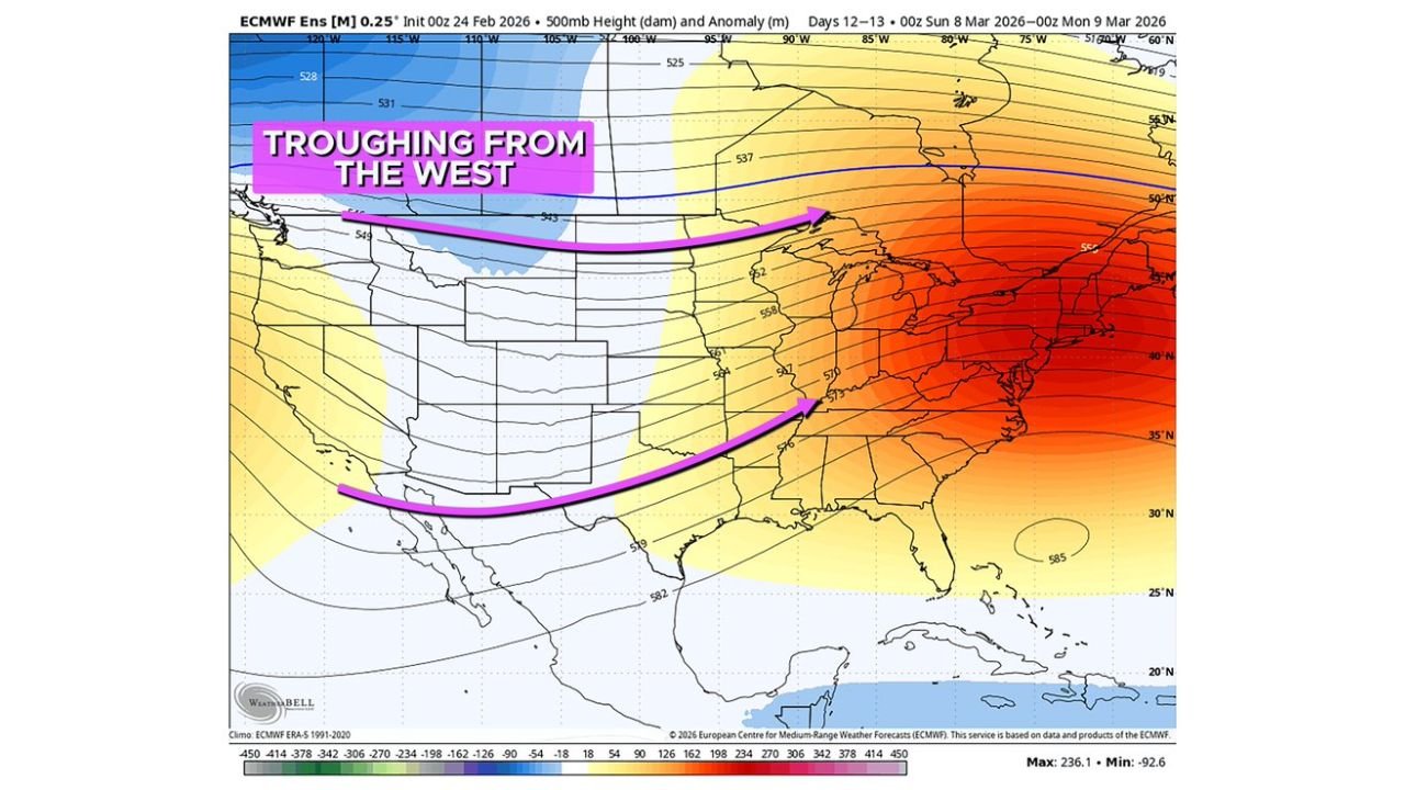
Western Troughing Re-Establishes Itself Over the West
Medium-range ensemble guidance for March 8–10 highlights a pronounced trough developing across the western United States. Lower 500mb heights are projected over:
- The Pacific Northwest
- Northern California
- The Great Basin
- The Rockies
At the same time, ridging strengthens across the eastern half of the country, particularly over the Midwest, Ohio Valley, and Northeast.
This west-to-east contrast is a classic spring transition pattern. As storm energy ejects out of the western trough and moves into the Plains, it typically interacts with increasing Gulf moisture and strengthening temperature contrasts — a combination that frequently leads to active storm development.
Warmer Than Average Temperatures Expand Across the Central U.S.
Temperature anomaly projections for March 9–14 show a broad region of above-normal warmth centered across the central United States.
The strongest warm anomalies are projected across:
- Kansas
- Nebraska
- Oklahoma
- Missouri
- Iowa
- Illinois
- Arkansas
- Indiana
- Kentucky
Temperatures in these states could run several degrees above seasonal averages. The warmth extends from the Southern Plains through the Mid-Mississippi Valley and into portions of the Midwest.
Cooler-than-average conditions are largely confined to parts of the Pacific Northwest and northern Rockies, reinforcing the western trough/eastern ridge configuration.
This expanding warm sector is critical, as it increases atmospheric instability — one of the necessary ingredients for severe thunderstorm development.
Wetter Than Average Corridor Forms From Texas to the Midwest
Five-day precipitation anomaly guidance for the March 8–13 window indicates a wetter-than-average signal stretching from eastern Texas northward through:
- Oklahoma
- Arkansas
- Missouri
- Illinois
- Indiana
- Kentucky
- Western Tennessee
This suggests repeated storm systems may track along a similar corridor, enhancing rainfall totals across the Mid-South and lower Ohio Valley.
While widespread flooding is not guaranteed at this range, repeated rainfall over the same areas could raise localized runoff concerns, particularly in low-lying or already saturated regions.
Severe Weather Risk Likely to Increase in Mid-March
Climatologically, March marks the early ramp-up of severe weather season across:
- The Southern Plains
- The Lower Mississippi Valley
- “Dixie Alley”
With warmer-than-average air spreading northward and a strong western trough supplying upper-level energy, the environment becomes more supportive of organized thunderstorm activity.
This type of setup can enhance:
- Wind shear profiles
- Thunderstorm organization
- Hail and damaging wind potential
- Tornado risk in favorable setups
Guidance suggests the severe risk zone may not remain confined to the Deep South. If the pattern fully materializes, portions of the Midwest could also see increasing storm chances during this period.
Specific outbreak days cannot yet be identified, but the broader environment appears more favorable for active weather compared to late February’s quieter pattern.
What This Means Heading Into Mid-March
The key driver of this shift is the return of sustained western troughing. Historically, this pattern supports:
- Warmer conditions east of the Rockies
- A more active storm track
- Expanding severe weather coverage
If ensemble guidance verifies, mid-March 2026 could feature a noticeable increase in thunderstorm activity across the Plains, Mid-South, and Midwest.
Forecast confidence will improve as the timeframe approaches, but the signal for a warmer, wetter, and potentially more volatile pattern is consistent across guidance.
Residents across the central and eastern United States should stay weather-aware as early spring conditions begin to take shape.
Stay with WaldronNews.com for continued updates as this evolving March pattern becomes clearer.