
Accumulating Snow Threat Looms for New York, Pennsylvania, Massachusetts and Connecticut as March 2–3 Winter Storm Targets the Northeast
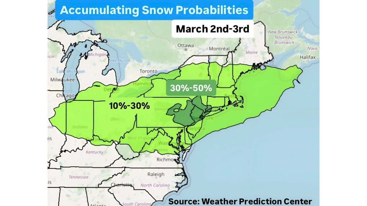
UNITED STATES — A new winter storm system may greet the start of March with accumulating snow across parts of the Northeast, as forecast guidance highlights increasing snow probabilities for Monday–Tuesday, March 2nd–3rd. The latest outlook from the Weather Prediction Center shows a broad swath of measurable snow potential stretching from the eastern Great Lakes into New England and portions of the Mid-Atlantic.
While details remain subject to change, confidence is growing that at least some areas could see plowable snowfall to begin the new month.
Snow Probability Zone Extends from Ohio to Coastal New England
Forecast probability maps indicate a corridor of accumulating snow extending across:
- Eastern Ohio
- Pennsylvania
- Upstate New York
- Vermont
- New Hampshire
- Massachusetts
- Connecticut
- Rhode Island
- Maine
The highest probability range — between 30% and 50% — is centered across portions of:
- Central and eastern New York
- Western and central Massachusetts
- Vermont
- New Hampshire
Surrounding areas, including parts of Pennsylvania, Ohio, Connecticut, Rhode Island, and southern Maine, fall within a 10% to 30% probability range for accumulating snowfall.
This suggests that while not all locations will see significant totals, the potential for measurable snow is fairly widespread across the region.
Mid-Atlantic Also in the Mix
The probability shading also includes portions of:
- Northern New Jersey
- Eastern Pennsylvania
- Delaware
- Maryland
- Northern Virginia
- West Virginia
Snow chances in these areas currently fall within the lower probability category, but even minor track adjustments could shift totals north or south.
Cities that may need to monitor this system closely include:
- New York City
- Philadelphia
- Boston
- Albany
- Hartford
- Providence
At this stage, the setup suggests a system capable of producing accumulating snow, particularly inland and across higher elevations.
Timing: Monday into Tuesday (March 2–3)
The window of concern is Monday through Tuesday, March 2nd–3rd. That timing could create potential travel disruptions, especially during early-week commutes.
If snowfall rates increase during peak travel periods, road conditions could deteriorate quickly — particularly across interior New York and New England.
Coastal locations may face greater uncertainty depending on storm track and temperature profiles.
What Remains Uncertain
While probability guidance highlights areas of concern, several factors still need refinement:
- Exact storm track
- Surface temperature profiles
- Rain vs. snow line placement
- Snowfall intensity bands
Small shifts in storm positioning could significantly change snowfall totals for cities along the I-95 corridor.
Higher elevations and interior regions currently appear more favored for steadier accumulating snow, but confidence will increase as short-range models come into better alignment.
Early March Reminder: Winter Isn’t Done Yet
Climatologically, early March can still deliver impactful snow events across the Northeast. The presence of a broad snow probability zone this far out suggests that winter may not be finished just yet.
Residents across Ohio, Pennsylvania, New York, New England, and parts of the Mid-Atlantic should continue monitoring forecast updates over the coming days.
Stay with WaldronNews.com for the latest updates as confidence grows regarding snowfall totals and potential impacts heading into March 2nd–3rd.