
Atmospheric River Soaks Southern Willamette Valley With Nearly 3 Inches of Rain, Rivers Rise as Parkdale, Oregon Picks Up 4 Inches of Snow
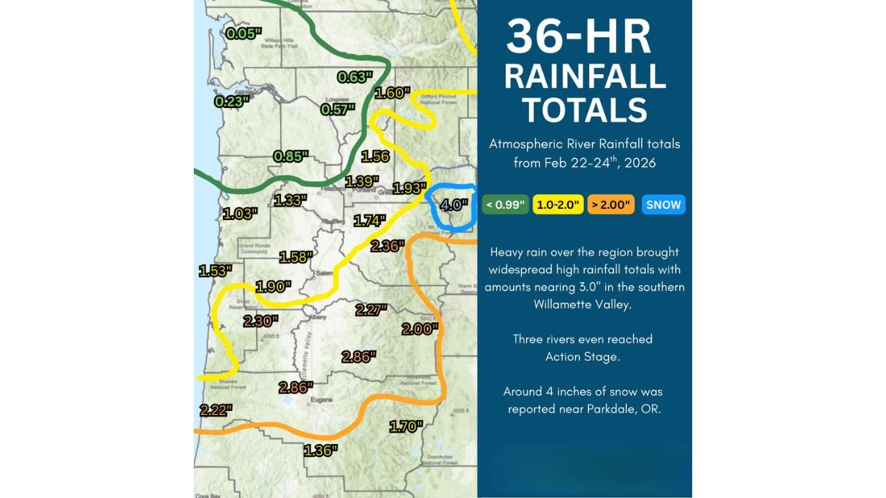
OREGON — A 36-hour atmospheric river event drenched parts of western Oregon between February 22–24, 2026, delivering the heaviest rainfall to the southern Willamette Valley while leaving some northwestern areas with significantly lighter totals. According to data from the National Weather Service in Portland, rainfall amounts approached 3 inches in parts of the valley, and three rivers reached Action Stage during the event.
Meanwhile, colder air in higher elevations allowed for measurable snowfall, with about 4 inches reported near Parkdale, Oregon.
Southern Willamette Valley Sees Highest Rainfall Totals
Rainfall data shows a pronounced concentration of heavier precipitation across the southern Willamette Valley and nearby foothills.
Some of the highest reported totals include:
- 2.86 inches near Eugene
- 2.86 inches in surrounding southern valley locations
- 2.36 inches east of Salem
- 2.30 inches near the central Coast Range
- 2.27 inches in the foothills south of Salem
- 2.22 inches in southwestern portions of the region
Areas around Salem recorded totals in the 1.58 to 1.90 inch range, while Portland and nearby communities generally measured between 1.39 and 1.74 inches.
This confirms that the stalled frontal boundary focused the heaviest rain south of Portland, aligning with the strongest atmospheric river moisture plume.
Northwestern Oregon Sees Lighter Amounts
In contrast, portions of northwestern Oregon experienced far lighter rainfall totals.
Notable readings include:
- 0.05 inches near the northwest corner of the state
- 0.23 inches along the northern coast
- 0.57 inches near Longview
- 0.63 inches in parts of southwest Washington
- 0.85 inches west of Portland
This sharp north-south rainfall gradient underscores how localized atmospheric river impacts can be when a frontal boundary stalls.
Rivers Reach Action Stage
Heavy rainfall over a relatively short period led to elevated river levels across parts of western Oregon. Officials reported that three rivers reached Action Stage, signaling heightened monitoring for potential minor flooding.
While widespread flooding was not indicated in the data provided, the combination of saturated soils and additional runoff contributed to rising waterways in the southern valley.
Snow Falls in Higher Elevations Near Parkdale
While rain dominated the valleys, colder air at elevation allowed snow to accumulate in parts of the Cascades.
Approximately 4 inches of snow was reported near Parkdale, Oregon, highlighting the elevation-dependent impacts of this atmospheric river event.
The snow accumulation likely occurred as moisture wrapped into higher terrain zones east of the Willamette Valley, where temperatures were cold enough to support frozen precipitation.
A Classic Atmospheric River Setup
Atmospheric rivers transport concentrated bands of Pacific moisture inland, often producing significant rainfall where terrain enhances lift. In this case, the stalled frontal boundary allowed moisture to focus persistently over the southern Willamette Valley, driving totals close to 3 inches in some locations.
Meanwhile, areas farther north remained on the weaker side of the moisture axis, resulting in much lighter accumulations.
What This Means Moving Forward
With soils now wetter across the southern Willamette Valley, additional storm systems could produce quicker runoff responses in the coming days.
The event serves as another reminder that atmospheric rivers can create highly uneven rainfall distributions, even across relatively short distances.
Stay with WaldronNews.com for continued weather updates as the Pacific Northwest transitions through the late-winter storm season.