
Lingering Weekend Front to Bring 1+ Inch Rainfall to Florida, Georgia and the Carolinas as Slow-Moving System Soaks the Southeast
UNITED STATES — A slow-moving frontal boundary is expected to slide into the Southeast this weekend, bringing periods of lingering rain from Friday into Saturday across Florida, Georgia and the Carolinas. While the system is not expected to deliver a strong cooldown, forecast guidance suggests it could produce widespread rainfall totals of one inch or more — especially across Florida.
The setup may disrupt outdoor plans, particularly across the Gulf Coast and Florida Peninsula, where rain coverage appears most persistent.
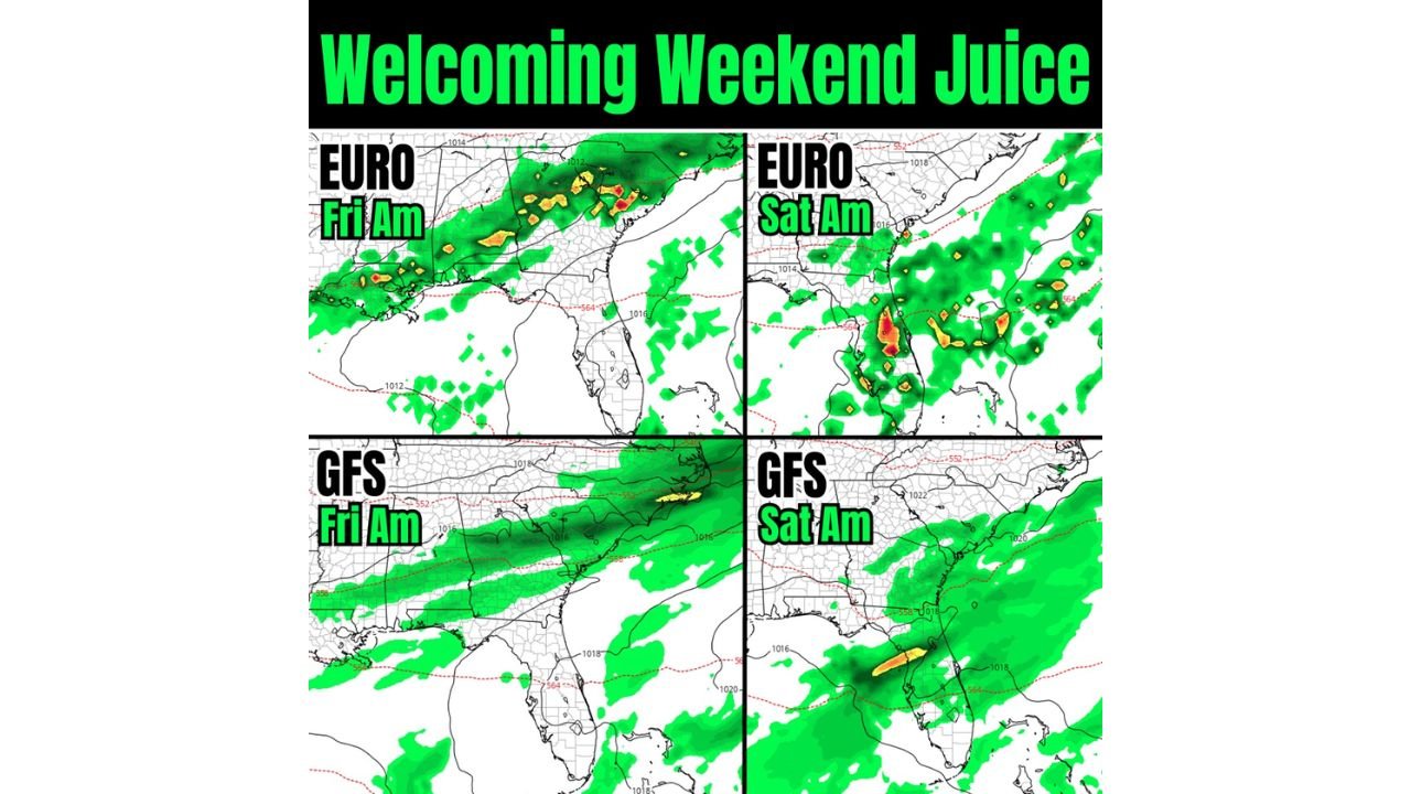
Friday Morning: Showers Spread Across the Gulf Coast and Northern Florida
Model guidance shows rain developing early Friday across:
- Southern Mississippi
- Southern Alabama
- The Florida Panhandle
- Northern Florida
- Southern Georgia
The European model (EURO) indicates scattered heavier downpours embedded within a broader rain shield across the Florida Panhandle and southern Georgia Friday morning.
The GFS solution also supports widespread rainfall, though it appears somewhat more uniform and less convective in structure compared to the EURO depiction.
Both models agree that the frontal boundary will stretch west to east across the northern Gulf Coast states, serving as the primary focus for rainfall.
Saturday Morning: Rain Shifts South and Lingers Over Florida
By Saturday morning, guidance shows the frontal boundary settling farther south, with rain concentrating over:
- Central Florida
- South Florida
- Coastal Georgia
- The eastern Gulf waters
The EURO solution highlights pockets of heavier rainfall across central Florida, including areas west of Orlando and south toward Tampa.
The GFS shows a similar southward progression, keeping steady rainfall across much of the Florida Peninsula into Saturday morning.
Rain chances also remain elevated along coastal Georgia and possibly parts of coastal South Carolina.
Widespread 1+ Inch Totals Possible
Given the slow movement of the boundary and repeated rounds of showers, widespread totals of at least one inch appear possible across:
- Northern Florida
- Central Florida
- Southern Georgia
Localized higher amounts could occur where heavier downpours persist, particularly in central Florida where convergence may be strongest.
Unlike stronger winter cold fronts, this system is described as relatively flat — meaning it will not bring a significant temperature drop but will instead focus more on moisture and prolonged rainfall.
Potential Impacts
While this does not currently appear to be a severe weather outbreak setup, impacts may include:
- Periods of moderate to heavy rainfall
- Wet road conditions
- Disruptions to weekend outdoor activities
- Localized ponding in poor drainage areas
The rainfall could also provide beneficial moisture to parts of the Southeast that have experienced dry conditions in recent weeks.
What to Watch
Key forecast uncertainties include:
- How long the boundary stalls over Florida
- Whether heavier rain bands repeatedly track over the same areas
- The exact north-south positioning of the heaviest rainfall axis
Even small shifts in frontal placement could alter which cities see the highest totals.
For now, residents across Florida, southern Georgia and coastal portions of the Southeast should plan for a damp start to the weekend.
Stay with WaldronNews.com for continued updates as this weekend rain system evolves.