
Historic New England “Snowicane” Explodes Offshore as Cyclone Horacio Becomes Earth’s First Category 5 Storm of 2026 in Rare Same-Day Rapid Intensification
UNITED STATES — In a stunning display of atmospheric extremes, two of the planet’s most powerful storm types underwent rapid intensification within the same 24-hour period — one off the coast of New England and the other in the Southern Hemisphere.
A cold-core extratropical cyclone strengthened explosively into a historic blizzard — often referred to as a “snowicane” — east of Massachusetts and Maine, while far to the south, Tropical Cyclone Horacio intensified into Earth’s first Category 5 storm of 2026.
The back-to-back intensification events highlight the extreme ends of ocean-driven storm development.
New England Snowicane Rapidly Deepens Offshore
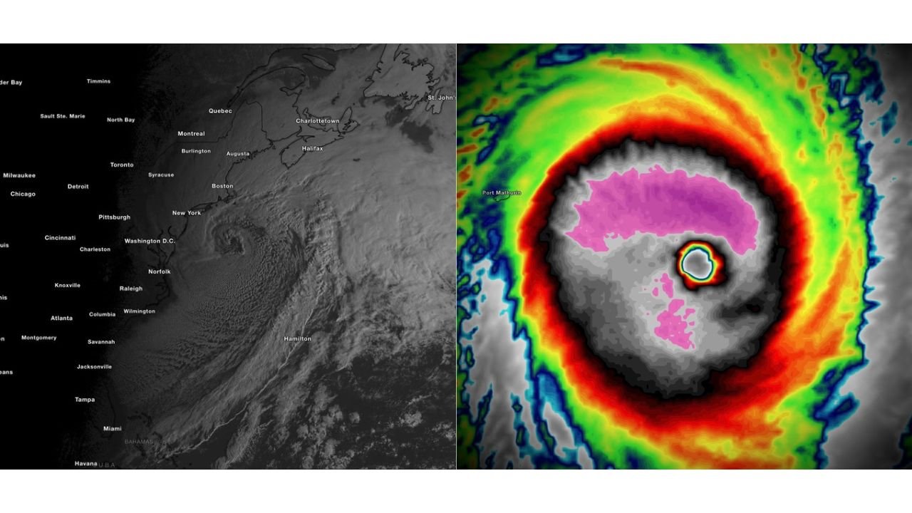
Satellite imagery shows a tightly wound, cold-core cyclone spinning off the Northeast coast, centered east of:
- Boston, Massachusetts
- Portland, Maine
- Halifax, Nova Scotia
The storm exhibits classic extratropical cyclone structure:
- A well-defined comma head
- Broad wraparound cloud shield
- Tight low-level circulation
- Expansive snow bands curling into coastal New England
The system intensified rapidly over the North Atlantic, strengthening into what forecasters are calling a historic blizzard offshore.
Given its structure and strength, the storm earned comparisons to a “snowicane” — an unofficial term used when extratropical cyclones take on hurricane-like satellite appearance while producing heavy snow and strong winds.
Cold-core cyclones derive their energy from temperature contrasts along frontal boundaries and upper-level dynamics, rather than warm ocean waters.
Cyclone Horacio Becomes First Category 5 of 2026
At the same time in the Southern Hemisphere, Tropical Cyclone Horacio rapidly intensified into a Category 5 system.
Infrared satellite imagery reveals:
- A sharply defined, compact eye
- Extremely cold cloud tops surrounding the eyewall
- Symmetrical structure indicating strong upper-level outflow
The storm’s appearance reflects classic warm-core tropical cyclone structure, powered by latent heat release over warm ocean waters.
With sustained winds reaching Category 5 intensity, Horacio became the first storm on Earth in 2026 to reach the highest classification on the Saffir-Simpson scale.
Two Storm Types, Two Hemispheres, One Extraordinary Day
The contrast between the two systems is striking:
New England Storm
- Cold-core extratropical cyclone
- Driven by upper-level dynamics and temperature gradients
- Producing heavy snow and strong winds
- Located in the Northern Hemisphere
Cyclone Horacio
- Warm-core tropical cyclone
- Fueled by warm ocean waters
- Achieved Category 5 intensity
- Located in the Southern Hemisphere
While fundamentally different in structure and energy source, both storms share one key trait: rapid intensification.
Rapid intensification occurs when environmental conditions align to allow a storm’s central pressure to drop quickly, dramatically increasing wind speeds and organization.
Witnessing this process in two separate hemispheres and storm types within the same day is exceptionally rare.
A Reminder of the Power of Oceanic Storm Systems
Extratropical cyclones and tropical cyclones represent the most powerful storm systems on Earth.
The North Atlantic snowicane demonstrated how winter systems can rapidly deepen into high-impact blizzards when atmospheric conditions align.
Meanwhile, Cyclone Horacio showcased the explosive strengthening potential of warm-core tropical systems over favorable waters.
Together, these events serve as a reminder that ocean-atmosphere interactions can produce extreme outcomes in any season — whether through snow-laden winter cyclones or intense tropical hurricanes.
Stay with WaldronNews.com for continuing coverage of both systems as impacts unfold across their respective regions.