
SPC Convective Outlook Maps for Texas, Louisiana, Mississippi, Alabama and Georgia Set for Major NOAA Update on March 3
UNITED STATES — The National Weather Service is preparing to roll out updates to the Storm Prediction Center’s (SPC) convective outlook graphics beginning March 3, bringing changes to how severe weather probabilities are displayed across the country — particularly in high-risk states like Texas, Louisiana, Mississippi, Alabama and Georgia.
The update will impact the familiar tornado, wind, and hail probability maps that millions rely on during peak severe weather season.
What Is Changing in the SPC Outlooks?
The SPC convective outlooks are the daily forecast maps outlining areas at risk for:
- Tornadoes
- Damaging wind
- Large hail
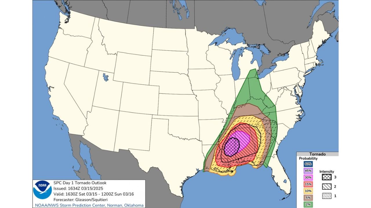
The example Day 1 Tornado Outlook shows a concentrated risk corridor stretching from:
- Southeast Texas
- Southern Louisiana
- Mississippi
- Alabama
- Western Georgia
Probability levels displayed on the current graphics include:
- 2% (green)
- 5% (brown)
- 10% (yellow)
- 15% (red)
- 30% (magenta)
- 45% (purple)
- 60% (blue, when applicable)
Hatched areas indicate the potential for significant (EF2+) tornadoes within the probability zone.
Beginning March 3, NOAA will update the design of these graphics to improve clarity and communication.
Why the Update Matters for the Deep South
States like:
- Texas
- Louisiana
- Mississippi
- Alabama
- Georgia
- Tennessee
frequently sit within the highest tornado probability zones during spring.
In the example shown, the 30%+ tornado probability core is centered over parts of southern Mississippi and Alabama, with surrounding 15% and 10% zones extending outward into Louisiana, Georgia, and Tennessee.
Improving the visual clarity of these probability areas is especially important in regions that routinely experience high-end severe weather outbreaks.
What Will Stay the Same?
The fundamental forecasting process remains unchanged. The probability percentages will still represent the chance of severe weather occurring within 25 miles of any given point.
Public risk categories — including:
- Marginal Risk
- Slight Risk
- Enhanced Risk
- Moderate Risk
- High Risk
will continue to accompany the probability graphics.
The update primarily focuses on improving visual readability and user interpretation.
Why Timing Is Critical
The March 3 rollout comes just as severe weather season ramps up across the Gulf Coast and Deep South.
Clear, intuitive forecast graphics are essential during high-impact setups when emergency managers and residents must quickly assess risk levels.
Small design improvements can enhance decision-making during fast-moving severe weather events.
Bottom Line
Beginning March 3, residents in Texas, Louisiana, Mississippi, Alabama, Georgia and surrounding states may notice updated SPC convective outlook graphics. While the science behind the forecasts remains the same, the presentation will be refined to improve clarity and public understanding.
As spring severe weather season accelerates, staying familiar with these outlook maps remains crucial.
Stay with WaldronNews.com for continued updates on severe weather developments and important forecasting changes.