
Arkansas, Oklahoma, Missouri and Tennessee Face Active Storm Pattern as Wetter-Than-Normal Zone Expands from Little Rock to St. Louis and Nashville Through Mid-March
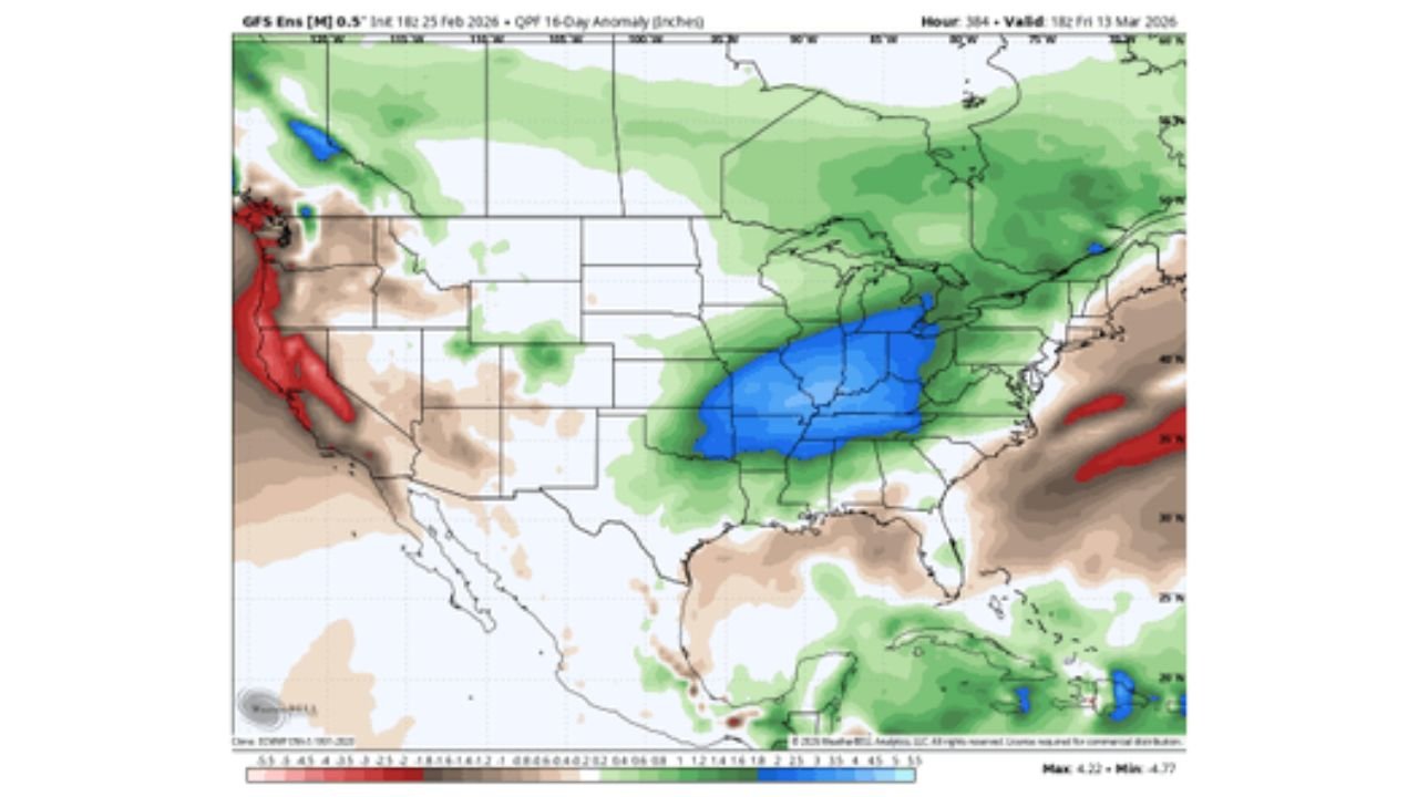
WALDRON, ARKANSAS — A major pattern shift is setting up across the central United States, with forecast data signaling an increasingly active stretch of storms and cold fronts during the first half of March. The latest model anomaly guidance highlights a significant wetter-than-normal corridor from Little Rock, Arkansas, through St. Louis, Missouri, and east toward Paducah, Kentucky, and Nashville, Tennessee.
The setup suggests multiple rounds of rain and at least two potential severe weather windows as the Heartland and Mid-South transition into early spring.
Wetter-Than-Normal Bullseye Over Arkansas and the Mid-South
Forecast anomaly maps show a concentrated zone of above-average precipitation centered over:
- Central and eastern Arkansas
- Southern and eastern Missouri
- Western Kentucky
- Western and Middle Tennessee
The heaviest anomaly shading covers areas including Little Rock, St. Louis, Paducah, and Nashville, indicating precipitation totals running well above early March climatological averages.
Western Arkansas, including Waldron and surrounding Scott County communities, falls within the broader wet signal, suggesting repeated rainfall chances rather than a single storm event.
Multiple Cold Fronts Driving Active Pattern
The pattern shift is being driven by a more amplified jet stream configuration, allowing energy to move out of the Rockies into the Plains and Mississippi Valley. Each passing disturbance is expected to drag cold fronts through the region, increasing:
- Rainfall frequency
- Thunderstorm potential
- Temperature swings
- The possibility of severe weather episodes
The guidance indicates at least two notable storm opportunities during the first two weeks of March, though exact timing will become clearer as short-range forecasts refine.
Severe Weather Risk Increasing
With Gulf moisture returning northward and stronger upper-level support arriving from the west, the environment across Arkansas, Oklahoma, Missouri, Tennessee, Mississippi, and Alabama may become favorable for strong to severe storms at times.
While it is too early to specify exact threat days, early March often marks the beginning of the spring severe weather ramp-up across the Mid-South.
Residents should remain alert for:
- Heavy rainfall leading to localized flooding
- Strong wind gusts
- Hail
- Isolated tornado potential
West Coast Trends Drier
In contrast, model guidance shows a notable break and drier conditions across much of the West Coast, particularly California. This shift supports a more active central U.S. storm track while the Pacific Coast experiences relatively quieter weather.
What This Means for Western Arkansas
For Waldron and western Arkansas, this evolving pattern likely means:
- Repeated rain chances over a 7–14 day period
- Potential for several rounds of thunderstorms
- Fluctuating temperatures as cold fronts pass
- Increased monitoring of severe weather outlooks
While early March can still feature late-season cold snaps, this setup emphasizes storm activity rather than prolonged Arctic air intrusions.
Early Spring Turning Active
As meteorological spring begins, the central U.S. appears poised for a dynamic and unsettled stretch. The corridor from Arkansas through Missouri and into Tennessee and Kentucky sits near the heart of the projected precipitation anomaly.
Forecast details will sharpen in the coming days, especially regarding timing and severity of individual systems.
Stay with WaldronNews.com for continued updates as this active early March pattern unfolds across Arkansas and the Mid-South.