
Texas, Oklahoma, Louisiana and Arkansas Face Renewed Severe Weather Threat as Gulf Moisture Surges North Ahead of March 8 System
UNITED STATES — After a brief lull, the atmospheric pattern across the Southern Plains and Lower Mississippi Valley appears primed for another round of severe weather as rich Gulf moisture surges northward into Texas, Oklahoma, Louisiana and Arkansas ahead of a developing system around March 8.
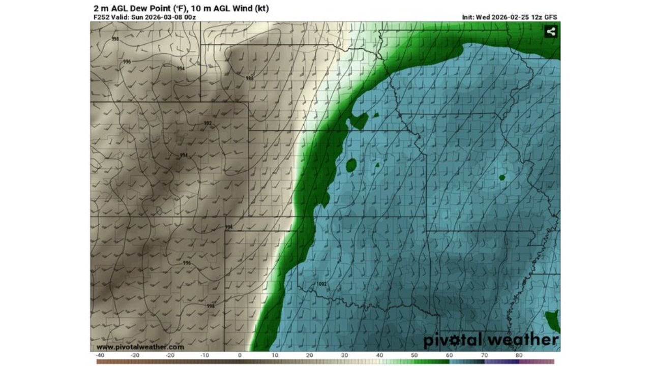
Forecast model data valid Sunday evening shows a sharp moisture boundary setting up across the region — a classic signal that severe weather ingredients are beginning to align.
Strong Gulf Moisture Return Into East Texas and Louisiana
Model projections of 2-meter dew points indicate a pronounced moisture gradient extending from:
- South and East Texas
- Western and Central Louisiana
- Southern Arkansas
- Into parts of Mississippi
Higher dew points (shown in deeper blue/green shading) are forecast to surge inland from the Gulf of Mexico, while much drier air remains in place across:
- West Texas
- Western Oklahoma
- Portions of the High Plains
This tight contrast between dry continental air and moist Gulf air often marks the battleground for strong thunderstorms.
Increasing Low-Level Winds Add Another Ingredient
The forecast also shows strengthening 10-meter winds across the Southern Plains and Lower Mississippi Valley.
Surface winds appear to turn more southerly across:
- East Texas
- Louisiana
- Arkansas
- Western Mississippi
Meanwhile, stronger southwesterly flow aloft overspreads:
- Western Oklahoma
- North and West Texas
This type of wind pattern can enhance wind shear — a critical component in organized severe storms, including supercells.
Classic Setup Taking Shape
The model panel highlights several severe weather ingredients coming together:
- Increasing low-level moisture
- Strengthening wind fields
- A sharp dryline separating moist and dry air masses
- A developing low-pressure system to the west
Historically, setups featuring a strong moisture return into Texas and Louisiana, combined with increasing shear across Oklahoma and Arkansas, can support:
- Damaging wind gusts
- Large hail
- Tornado potential
While it is still several days out, forecasters are monitoring the pattern closely.
Why This Pattern Matters
The Southern Plains and Lower Mississippi Valley are climatologically active in early March. When Gulf moisture surges north after a period of dry air dominance, it often signals the return of springlike severe weather conditions.
The phrase “We are so back” circulating in weather discussions reflects growing confidence that the severe weather pattern may be reactivating after quieter stretches.
What to Watch Next
Key factors that will determine storm intensity include:
- How far north richer dew points advance
- Strength and timing of the approaching upper-level disturbance
- Placement of the dryline and any warm front boundaries
Small shifts in these features can dramatically change which states see the highest severe threat.
Bottom Line
Texas, Oklahoma, Louisiana and Arkansas could be facing a renewed severe weather setup around March 8 as Gulf moisture surges inland and wind fields strengthen across the Southern Plains.
It is too early for specifics, but the ingredients are beginning to align for a potentially active period.
Stay with WaldronNews.com for updated severe weather outlooks and regional breakdowns as this developing system draws closer.