
Texas, Oklahoma, Kansas and Colorado Forecast to Be Dry — But Reality Turned Much Wetter Across Texas and the Southern Plains Last Summer
UNITED STATES — Seasonal forecast models once painted a broad dry signal across Texas, Oklahoma, Kansas and Colorado for late spring into summer — but what actually unfolded on the ground told a far different story.
New comparisons between last year’s European seasonal precipitation outlook for May, June and July and the observed rainfall anomalies show just how dramatically long-range projections can miss when key atmospheric drivers fail to align.
What the Seasonal Model Predicted
The first graphic — the European seasonal model forecast issued in early February — showed:
- Widespread below-normal precipitation across Texas, Oklahoma, Kansas and eastern Colorado
- Drier-than-average conditions extending into parts of New Mexico
- Only limited wetter signals east of the Mississippi River
The map was dominated by brown shading, signaling a dry spring-to-summer transition across much of the Southern Plains.
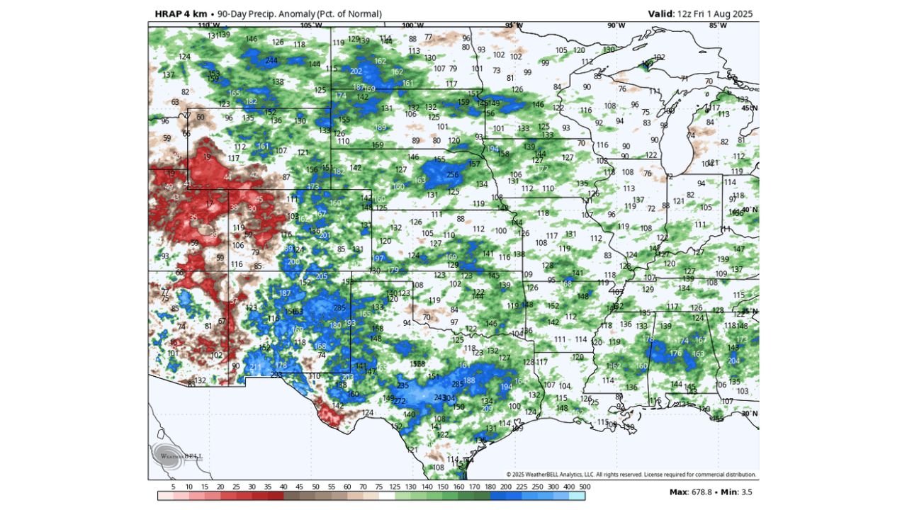
What Actually Happened
The second graphic — observed precipitation anomalies through August — tells a sharply different story.
Instead of persistent dryness:
- Large portions of Texas experienced well above-normal rainfall
- Significant areas of Oklahoma and southern Kansas turned much wetter than forecast
- Repeated storm systems delivered widespread moisture into the Southern Plains
Some areas in Texas saw rainfall percentages well above 150% of normal, with localized totals even higher.
Meanwhile, drier conditions verified more accurately in parts of the western High Plains and interior West — but the core Southern Plains forecast was clearly off target.
Why Seasonal Models Struggle
Seasonal models can provide useful guidance when a strong atmospheric or oceanic signal — such as El Niño or La Niña — is firmly established.
However, when signals are weak or evolving:
- Jet stream positioning can shift unexpectedly
- Storm tracks may deviate from long-range projections
- Moisture transport patterns can rapidly reorganize
In last year’s case, the Southern Plains storm track remained more active than expected, delivering repeated rainfall events.
The Takeaway for 2026
The comparison serves as a reminder that long-range outlooks are not guarantees.
While they offer broad trend guidance, they:
- Do not predict individual storm systems
- Cannot fully anticipate regional atmospheric shifts months in advance
- Should be used alongside shorter-range forecasts
For farmers, ranchers and water managers across Texas, Oklahoma, Kansas and Colorado, last year’s example highlights the importance of staying flexible as patterns evolve.
Bottom Line
A seasonal forecast once pointed toward widespread dryness across Texas, Oklahoma, Kansas and Colorado — but the actual May–July rainfall totals ended up dramatically wetter across large portions of the Southern Plains.
As new seasonal outlooks are released, this case underscores one key lesson: long-range forecasts can hint at trends, but the atmosphere often has the final word.
WaldronNews.com will continue comparing forecast guidance with real-world outcomes as we head deeper into the 2026 warm season.