
Climate Prediction Center Flags High Risk of Heavy Rainfall for Arkansas, Oklahoma, Texas, Missouri and Tennessee March 6–10 — Waldron Area in Target Zone
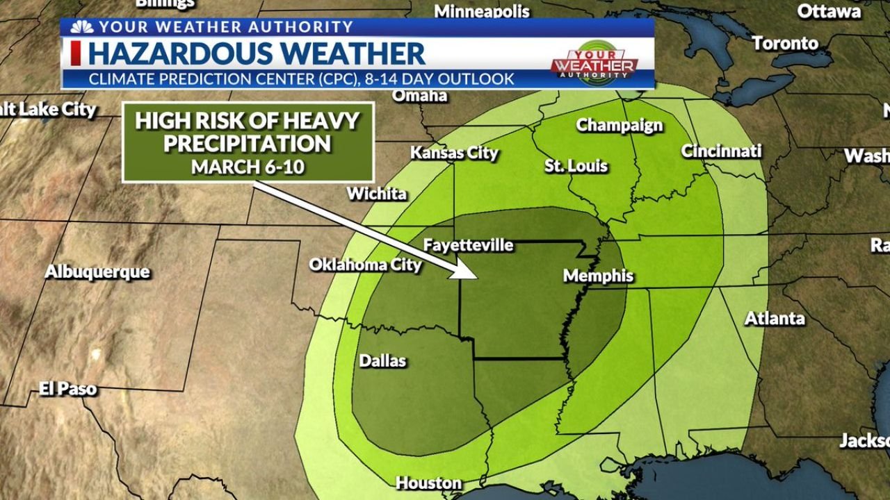
ARKANSAS — A rare “High Risk” of Heavy Precipitation has been issued for parts of the South-Central United States in the March 6–10 timeframe, according to the Climate Prediction Center’s 8–14 day outlook — and western Arkansas, including the Waldron area, sits squarely within the highlighted zone.
Forecasters say this type of high-confidence signal does not appear often in extended outlooks, signaling growing confidence that an active weather pattern will take hold across the region in early March.
Arkansas and Surrounding States in the Bullseye
The outlook places a broad swath of enhanced heavy precipitation risk across:
- Western and Central Arkansas (including Fayetteville and surrounding areas)
- Eastern Oklahoma (including Oklahoma City)
- North Texas (including Dallas)
- Western Tennessee (including Memphis)
- Southern Missouri (near Kansas City and St. Louis corridor)
- Portions of Louisiana and East Texas (Houston area)
The highest shading on the map stretches from North Texas northeastward through eastern Oklahoma and into western and central Arkansas — putting the Waldron region within the more favored corridor for above-normal rainfall potential.
Why This Outlook Stands Out
Extended outlooks often show “above average” signals. However, a “High Risk” designation in the 8–14 day window is much less common and suggests:
- Strong model agreement
- A persistent storm track
- Potential for repeated rounds of rainfall
- Elevated confidence in an active pattern continuing into week two
Forecasters indicate very high confidence that this unsettled pattern will continue during that period.
What This Could Mean for Waldron and Western Arkansas
If the projected pattern verifies, impacts could include:
- Multiple rain events between March 6 and March 10
- Periods of heavier rainfall rates
- Localized flooding in low-lying or poor-drainage areas
- Rising creeks and streams
- Saturated soils heading deeper into March
While exact rainfall totals cannot yet be pinpointed this far out, the large-scale pattern suggests a corridor of enhanced precipitation stretching directly across western Arkansas.
Surrounding Metro Areas Also in Line
Major cities within or near the highlighted risk zone include:
- Dallas, Texas
- Oklahoma City, Oklahoma
- Fayetteville, Arkansas
- Memphis, Tennessee
- St. Louis, Missouri
- Kansas City, Missouri
The risk zone arcs from North Texas through Arkansas and into parts of the Mid-Mississippi Valley.
Timing and Next Steps
The window of concern is currently March 6–10, but specific storm systems will become clearer as we move closer to the timeframe.
Residents in Waldron and across Scott County should:
- Monitor updated local forecasts
- Keep drainage areas clear
- Stay aware of potential flood advisories if confidence continues to increase
Bottom Line
A High Risk of Heavy Precipitation across Arkansas, Oklahoma, Texas, Missouri and Tennessee during March 6–10 signals a potentially active and wet stretch ahead for the Waldron region. While details will refine in the coming days, early indicators suggest western Arkansas could see repeated rounds of rainfall during that period.
WaldronNews.com will continue tracking updates as forecast models narrow down timing and rainfall amounts.