
Warm Storm Cuts Into Western U.S. Snowpack as Levels Drop to 19 Inches SWE Now Just 67% of Median Heading Toward Spring
UNITED STATES — A temporary boost from this week’s rain has already faded across parts of the western U.S. snowpack, and new data shows snow water equivalent (SWE) levels slipping back below seasonal averages as warmer storms eat away at accumulated snow.
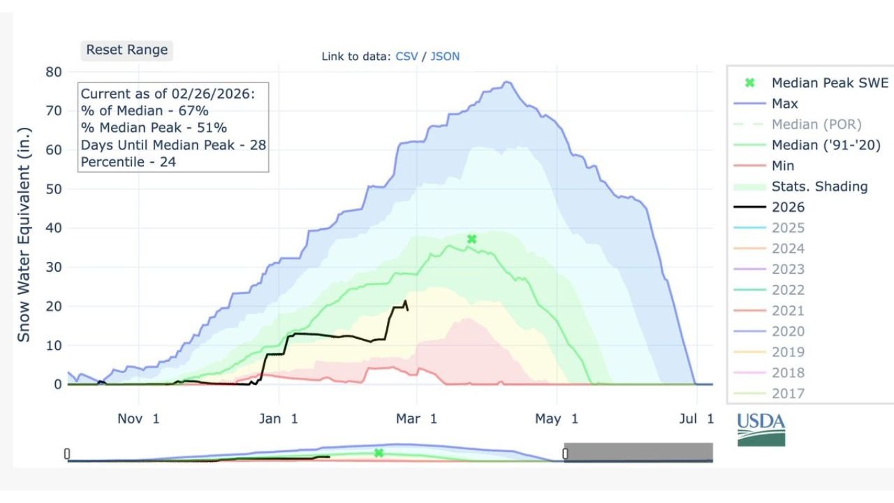
According to updated snowpack data as of February 26, 2026, current conditions show:
- 67% of median snow water equivalent
- 51% of median peak
- 24th percentile ranking
- Approximately 28 days until the climatological median peak
- Current total sitting near 19 inches, down from 19.7 inches at the end of last week’s snowfall
Temporary Boost Quickly Lost
Earlier rainfall temporarily increased SWE by about 1.7 inches, but that gain exited through the base of the snowpack. The warm system not only added water briefly — it also melted part of the snowpack, reducing overall totals.
The result: snow levels have retreated rather than strengthened heading into early March.
Where the Snowpack Stands Compared to Normal
The USDA snowpack chart shows the 2026 line tracking well below the historical maximum envelope and also below the long-term median curve for this point in the season.
Key takeaways from the data:
- Snowpack is currently one-third below median levels
- Peak seasonal accumulation has likely not yet occurred
- Conditions rank in the lower quarter historically
- The melt season is approaching sooner if warm systems continue
While median peak snowpack typically occurs in late March or early April depending on elevation, this year’s snowpack is significantly underperforming compared to average years.
Why Snow Water Equivalent Matters
Snow Water Equivalent (SWE) measures how much water is stored in the snowpack. It plays a critical role in:
- Spring runoff
- River levels
- Reservoir supply
- Irrigation availability
- Summer drought outlook
When warm storms deliver rain instead of snow — or melt existing snow — overall seasonal water storage can decline rapidly.
What This Means Moving Forward
With roughly four weeks until the typical peak snowpack, the next several systems will determine whether levels recover or continue sliding below normal.
If warm patterns persist:
- Snowpack could struggle to reach median peak
- Earlier melt may accelerate runoff timing
- Water supply concerns could grow in drier basins
If colder storms return:
- Late-season snowfall could still boost totals
- Peak accumulation may shift slightly later
The Bottom Line
The recent warm storm erased a short-lived 1.7-inch SWE gain and trimmed snowpack levels back to 19 inches, now sitting at 67% of median and in the 24th percentile. With about 28 days until typical peak accumulation, the window for meaningful recovery is narrowing.
WaldronNews.com will continue monitoring national snowpack trends and their potential downstream impacts as we move closer to spring.