
Washington, D.C. Stuck in a ‘Snow Hole’ Again as La Niña Pattern Sends Major Snowstorms North and South, Here’s What the Maps Show
WASHINGTON, D.C. — Despite a cold and wintry season across much of the eastern United States, Washington, D.C. has once again found itself in what meteorologists call a “snow hole,” missing out on the region’s biggest snowstorms while surrounding areas pile up above-average totals.
According to the data shown, D.C. has recorded 9.6 inches of snow so far this winter, compared to a seasonal normal of 11.4 inches. While that may not sound dramatically low, it represents a notable shortfall — especially in a year when snow and ice have lingered on the ground for extended stretches.
Snowfall Running Below Average in the D.C. Area
The nationwide snowfall comparison map (covering Sept. 30, 2025 through Feb. 26, 2026) shows a clear pattern: large portions of the country are near or below average, but significant above-average snow pockets have developed both north and south of the nation’s capital.
D.C. sits within a corridor of lighter blue shading, indicating near-average to slightly below-average snowfall. Meanwhile:
- Parts of North Carolina and southern Virginia are shaded in darker tones, signaling well above-average snowfall.
- The Northeast corridor from Philadelphia to Boston also shows healthy snow totals compared to climatology.
- Interior sections of the Midwest and central U.S. display widespread below-average snowfall.
This uneven distribution has left D.C. in a frustrating middle ground.
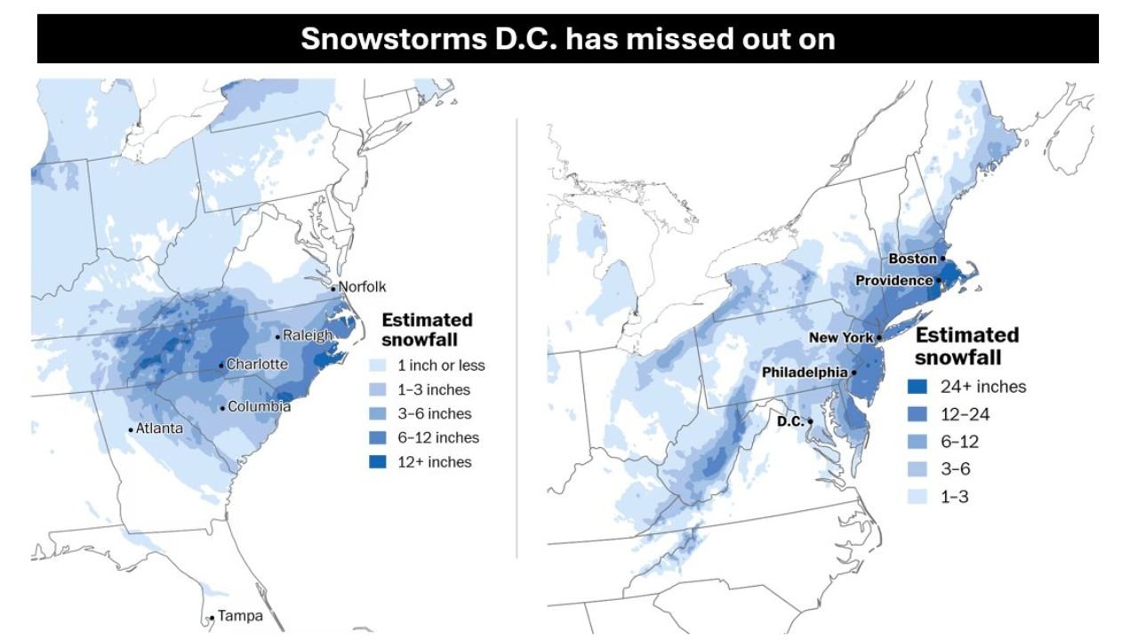
Two Major Snowstorms Missed the Capital
The second set of maps highlights two specific storm systems that largely bypassed Washington, D.C.
Jan. 31 – Feb. 1 Storm
During this event, heavy snowfall targeted areas to the south, including:
- Charlotte
- Raleigh
- Columbia
- Portions of southeastern Virginia near Norfolk
Many of these locations picked up several inches, with some zones exceeding 6–12 inches. D.C., however, remained on the northern fringe, receiving far less accumulation.
Feb. 22–23 Nor’easter
Later in February, a classic Nor’easter developed and tracked farther north. This system brought significant snowfall to:
- Philadelphia
- New York
- Providence
- Boston
Some areas in New England recorded double-digit snowfall totals. Once again, Washington, D.C. fell on the southern edge of meaningful accumulation.
A Classic La Niña Snow Pattern
Meteorologists note that this “split storm track” pattern is common during La Niña winters. In these setups:
- Storm systems frequently track either north of D.C. toward the Northeast.
- Or they dive south, bringing heavier snow to the Carolinas and southeastern Virginia.
- The Mid-Atlantic region — particularly D.C. — often ends up squeezed between these favored zones.
The result is a recurring “snow hole,” where moisture and heavy precipitation repeatedly steer around the capital region.
What This Means for the Rest of Winter
With snowfall totals still trailing the seasonal norm, D.C. would need at least another couple of moderate events to catch up to average.
However, if the current pattern holds — with storms continuing to favor areas north and south — the capital may close out winter below its 11.4-inch normal.
For snow lovers in D.C., it has been a particularly frustrating season: cold air has been present, snow has stuck around for long stretches, but the blockbuster storms have repeatedly tracked just far enough away to deny major accumulations.
The Bigger National Picture
Nationally, snowfall has been uneven. The map shows:
- Large swaths of the West and central U.S. running below average.
- Concentrated above-average snowfall in parts of the Southeast and Northeast.
- White-shaded areas indicating little to no measurable snow in some southern zones.
This regional variability underscores how storm tracks — sometimes shifting only 50 to 100 miles — can dramatically alter winter outcomes for major cities.
As winter winds down, Washington, D.C.’s position in the “snow hole” remains a defining story of the 2025–2026 season.
For continued weather analysis and updates that matter to our community, stay connected with WaldronNews.com.