
Severe Storms Intensifying Across Southern Missouri and Northern Arkansas as SPC Warns of Hail, Damaging Winds and Isolated Tornado Risk Tonight
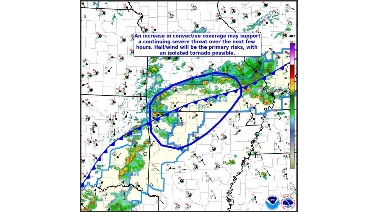
MISSOURI–ARKANSAS — The National Weather Service Storm Prediction Center (SPC) has issued a Mesoscale Discussion for parts of southern Missouri and northern Arkansas, warning that strengthening atmospheric conditions could sustain severe thunderstorms across the region over the next several hours.
The discussion highlights a developing environment where increasing lift in the atmosphere and a strengthening low-level jet stream are expected to maintain and potentially intensify storms through the evening.
Forecasters say the main hazards will be large hail and damaging wind gusts, although an isolated tornado cannot be ruled out.
Severe Thunderstorm Watch Expanding Into Northern Arkansas
According to the SPC, Severe Thunderstorm Watch 11 — which was previously in place across portions of Missouri — may be extended locally into parts of northern Arkansas as storms continue to organize along a frontal boundary moving across the region.
Radar imagery shows clusters of thunderstorms developing and moving east-northeast across areas including:
- Southern Missouri
- Northern Arkansas
- Areas near the Arkansas–Missouri state line
These storms are expected to increase in coverage as atmospheric forcing strengthens.
Hail and Damaging Winds the Primary Threats
Forecasters indicate that hail and strong wind gusts will be the dominant severe weather threats as storms continue through the evening.
Peak hazard estimates from the mesoscale discussion suggest:
- Wind gusts between 55 and 70 mph
- Hail sizes ranging from 1.00 to 1.75 inches in diameter
Hail of this size can cause damage to vehicles, roofs, and crops, while wind gusts approaching 70 mph may down trees and power lines.
Increasing Storm Coverage Expected
Meteorologists say an increase in thunderstorm coverage is likely over the next few hours, which could prolong the severe weather threat across the region.
The strengthening low-level jet stream — a fast-moving corridor of winds a few thousand feet above the ground — is helping storms maintain intensity as they track eastward.
This atmospheric setup often supports longer-lasting storm clusters capable of producing multiple rounds of severe weather.
Isolated Tornado Cannot Be Ruled Out
While the primary concern remains hail and wind damage, the SPC notes that an isolated tornado is possible if one of the storms develops stronger rotation.
Such tornado potential typically occurs when thunderstorms interact with localized boundaries or experience stronger low-level wind shear.
However, tornado risk is currently considered secondary compared with hail and wind threats.
Areas That Could See Storm Impacts
Communities across the following areas should remain alert for severe weather warnings tonight:
- Springfield, Missouri
- Branson, Missouri
- West Plains, Missouri
- Mountain Home, Arkansas
- Harrison, Arkansas
- Batesville, Arkansas
Storms may continue moving through the region during the evening hours before gradually weakening overnight.
WaldronNews Monitoring the Developing Situation
Severe weather conditions can change rapidly as thunderstorms intensify or shift direction.
WaldronNews will continue monitoring radar trends and official warnings from the National Weather Service, providing updates as storms evolve across Missouri and Arkansas.
Residents are encouraged to stay alert for severe thunderstorm warnings, potential watch extensions, and changing weather conditions throughout the evening.