
Michigan Storm That Produced Multiple Strong Tornadoes Weakens After Crossing Warm Front Near Jackson and Albion
JACKSON, MICHIGAN — A dangerous storm system that earlier produced multiple strong and intense tornadoes across parts of Michigan has now weakened significantly after crossing a key weather boundary, reducing the immediate tornado threat across the region.
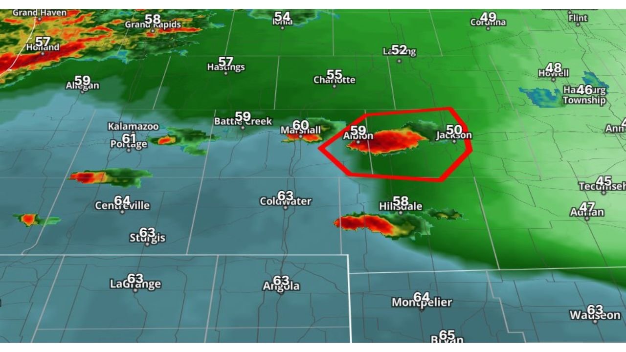
Radar data shows the storm moving eastward through south-central Michigan, with the strongest thunderstorm activity passing near Albion and Jackson before entering a cooler air mass north of the warm front. Once the storm crossed this boundary, the atmospheric conditions supporting tornado formation quickly diminished.
While thunderstorms remain active in the area, the environment that previously supported strong tornadoes is no longer present.
Storm Produced Tornado Threat Earlier in Michigan
Earlier in the event, the storm moved through parts of southern Michigan, where the atmosphere contained warm, unstable air capable of supporting powerful rotating thunderstorms.
During this phase, storms were capable of producing multiple strong or intense tornadoes, making the situation particularly dangerous across areas west of Jackson.
The radar imagery shows the most recent storm core centered between Albion and Jackson, where heavy rainfall and strong thunderstorm activity were still occurring as the system tracked east.
Crossing the Warm Front Changed the Storm Environment
The weakening of the tornado threat occurred after the storm crossed north of a warm front, a boundary separating warm, unstable air from cooler and more stable air.
South of the warm front, storms can tap into warm, humid air that fuels strong updrafts and storm rotation. However, once storms move north of that boundary into cooler air, the instability needed for tornado formation rapidly decreases.
That is exactly what occurred as the storm progressed toward Jackson and surrounding communities.
Temperature readings across the region show the contrast between the air masses, with areas north of the front experiencing cooler temperatures near the 50s, compared to warmer conditions farther south.
Because of this shift in the atmospheric environment, the storm no longer has the ingredients required to sustain tornado-producing rotation.
Thunderstorms Still Producing Heavy Rain and Lightning
Even though the tornado risk has diminished, the storm continues to produce heavy rainfall, lightning, and localized downpours across parts of southern Michigan.
Radar imagery shows additional thunderstorm cells nearby, including areas around:
- Kalamazoo
- Battle Creek
- Coldwater
- Hillsdale
These storms may still produce brief bursts of heavy rain and occasional lightning as they move east across the region.
Drivers traveling along major roadways including Interstate 94 and nearby highways around Jackson may encounter rapidly changing weather conditions.
Severe Threat Continues to Shift East
As the storm system continues to move eastward, the most intense tornado threat associated with the earlier storms has diminished significantly.
The remaining storms are expected to behave more like typical thunderstorms, with localized heavy rain and lightning rather than organized tornado-producing supercells.
However, scattered storms across southern Michigan could still cause temporary disruptions, especially during periods of heavier rainfall.
Storm Activity Continues Across Southern Michigan
Weather conditions across the region remain unsettled as the broader storm system continues moving across the Midwest.
Additional thunderstorms remain possible through the evening, although the most dangerous tornado-producing phase of this system has now ended after the storm moved into cooler air north of the warm front.
Residents across southern Michigan should still monitor weather conditions, particularly during thunderstorms that may bring lightning and heavy rain.
Stay with WaldronNews for continuing updates on severe weather and storm developments across Michigan and the Midwest.