
Indiana, Illinois, Kentucky, Tennessee, Arkansas and Mississippi Face Morning Severe Storm Line With Possible Tornadoes and Damaging Winds Saturday
UNITED STATES — A developing line of thunderstorms is expected to sweep across several states Saturday morning and afternoon, bringing a potential for damaging wind gusts and brief tornadoes from Indiana through Illinois, Kentucky, Tennessee and into Arkansas and Mississippi.
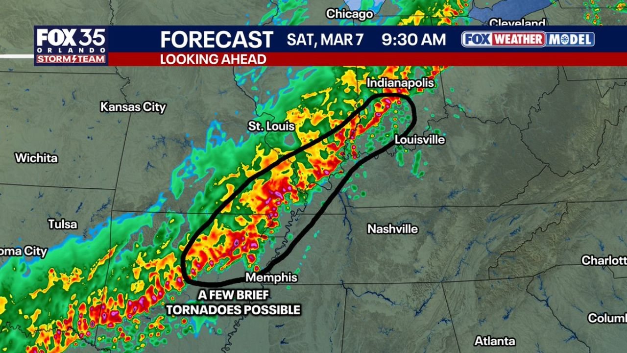
Forecast guidance shows a fast-moving band of storms forming overnight and strengthening as it pushes eastward across the Mississippi Valley early Saturday. While the system may appear as a typical line of rain and storms, the environment along the leading edge could support localized severe weather, particularly during the morning hours.
Storm Line Expected to Stretch From Indiana to Arkansas
Weather models indicate the storm system will organize into a narrow but active line of thunderstorms stretching from central Indiana through southern Illinois, western Kentucky, western Tennessee and into eastern Arkansas.
Cities located near the projected storm corridor include:
- Indianapolis, Indiana
- St. Louis, Missouri
- Louisville, Kentucky
- Memphis, Tennessee
This band of storms is expected to move quickly, meaning areas along its path could experience rapid changes in weather conditions with heavy rain, strong wind gusts and lightning.
The most concentrated storm activity early Saturday morning appears likely to develop along a corridor extending from Memphis northeast toward Louisville and Indianapolis.
Morning Hours Could Bring Brief Tornado Risk
Between 8:00 AM and 10:00 AM, conditions may briefly become favorable for stronger storms along parts of the line.
During this period, areas including:
- Southern Illinois
- Western Kentucky
- Northwest Tennessee
could experience damaging wind gusts or possibly one or two brief tornadoes embedded within the line of storms.
Storm systems organized in a line can occasionally spin up short-lived tornadoes along their leading edge. These events often develop quickly and can occur with little warning compared to isolated supercell storms.
Storms Expected to Move Into Tennessee by Early Afternoon
As the line of storms continues moving east, the strongest activity is expected to shift into middle Tennessee by early Saturday afternoon, potentially impacting communities including Nashville and surrounding areas.
While the storms may begin to weaken somewhat as they move deeper into the region, the line could still produce heavy rainfall, strong wind gusts and lightning during the early afternoon hours.
The system is forecast to continue tracking southeast toward northern Mississippi and northern Alabama later Saturday afternoon, where the storm line may gradually lose strength and break apart.
Fast-Moving Storms Could Bring Sudden Weather Changes
Because this system will likely move quickly across the region, residents may experience rapid shifts from calm weather to strong storms within a short period of time.
Storm lines of this type often produce the most intense wind gusts along the front edge, where thunderstorms push outward in a long arc across multiple states.
Even when tornadoes do not form, these storms can still cause tree damage, power outages and hazardous driving conditions, especially during morning travel hours.
Large Multi-State Area Monitoring Storm Progression
The storm system is expected to impact a wide section of the central and southern United States as it progresses eastward throughout Saturday.
States potentially affected include:
- Indiana
- Illinois
- Kentucky
- Tennessee
- Arkansas
- Mississippi
- Alabama
Although the most intense storms are expected during the morning hours, conditions may continue to shift throughout the day as the system moves southeast.
Residents Urged to Monitor Weather Alerts
Morning storm systems can sometimes catch people off guard, particularly when they arrive during early travel hours or weekend activities.
Residents across the Mississippi Valley and Tennessee Valley regions should stay aware of local weather alerts and be prepared for possible strong storms Saturday morning.
Stay with WaldronNews for continuing coverage and updates as this developing storm system moves across multiple states.