
Severe Storm Threat Targets Pittsburgh, Erie, Butler and Western Pennsylvania Saturday as Near-Record Warmth Collides With Cold Front
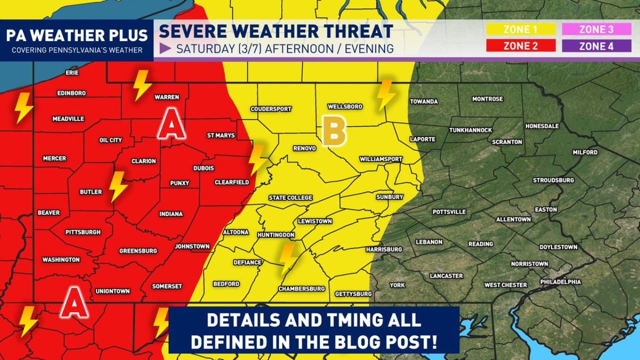
PENNSYLVANIA — A developing weather pattern could bring strong to potentially severe thunderstorms to western Pennsylvania on Saturday, as near-record warmth and rising humidity combine with an approaching cold front to create unstable conditions across the region.
Meteorologists say the greatest concern will be across western Pennsylvania, where storms are expected to encounter the most favorable atmospheric conditions before weakening as they move east across the state.
Western Pennsylvania Faces Highest Storm Risk
Forecast maps highlighting the severe weather setup show the highest risk zone across western Pennsylvania, including areas around:
- Pittsburgh
- Erie
- Butler
- Clarion
- Oil City
- Dubois
- Indiana
- Greensburg
- Washington
These areas fall within the region most likely to experience strong thunderstorms capable of producing damaging wind gusts, heavy rain, and frequent lightning during the afternoon and evening hours Saturday.
The approaching cold front will act as the main trigger for storm development, forcing warm, moist air upward and allowing thunderstorms to intensify.
Warm and Humid Air Fueling the Storm Setup
The severe weather potential is developing because unusually warm temperatures and increasing humidity are spreading across Pennsylvania ahead of the incoming cold front.
Warm, moisture-rich air provides the fuel thunderstorms need to grow stronger. As the cold front pushes into this unstable air mass, it will likely spark a line of storms moving west to east across the state.
Meteorologists note that temperatures approaching record levels for early March are helping to increase the instability needed for stronger storms.
Storms Expected to Weaken Moving East
While western Pennsylvania may see the strongest storms, the threat is expected to decrease as the system pushes farther east across the state.
Central Pennsylvania locations such as:
- State College
- Altoona
- Williamsport
- Sunbury
- Lewistown
remain in a lower-level risk zone, where thunderstorms are still possible but are less likely to reach severe intensity.
Forecasters say storms may encounter more stable air across eastern Pennsylvania, limiting their strength as they move toward areas like Harrisburg, Lancaster, and the Philadelphia region.
Timing Points to Saturday Afternoon and Evening
The most likely window for storm development appears to be Saturday afternoon through early evening, when atmospheric instability will be at its highest.
Residents in western Pennsylvania should monitor weather updates during this timeframe, particularly if outdoor activities are planned.
Storms during this period could produce:
- Strong wind gusts
- Heavy downpours
- Frequent lightning
- Brief localized storm intensification
Residents Urged to Stay Weather Aware
Although not every location will experience severe weather, forecasters recommend that residents across western and central Pennsylvania stay alert as storms move into the region.
Weather conditions could change quickly once thunderstorms begin forming along the cold front.
Having multiple ways to receive weather alerts and keeping an eye on radar updates will be important as the storm system approaches.
Stay with WaldronNews for continued weather updates as meteorologists track Saturday’s developing severe storm threat across Pennsylvania.