
Northern Texas Through Arkansas, Mississippi, Tennessee and Kentucky Face Very High Hail Probability Today as Supercell Thunderstorms Fire Along Major Cold Front
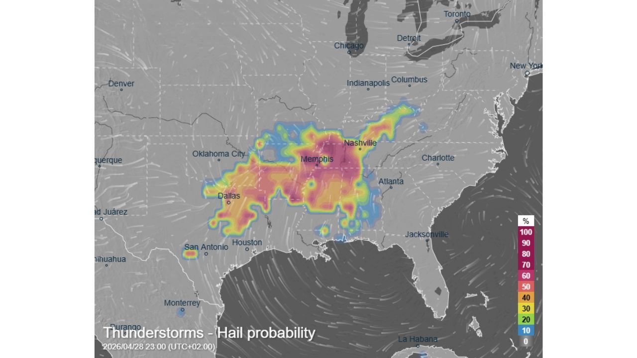
MEMPHIS, Tennessee — A significant and dangerous severe weather outbreak is underway today across the central and southeastern United States, with very high to near-certain probability of hail within thunderstorms stretching from northern Texas through Arkansas, Mississippi, and Tennessee into Kentucky and parts of Alabama. The hail probability map shows the red and pink core — representing 80 to 100% probability — centered directly over the Memphis corridor, making this one of the most concentrated hail threat zones seen across the region this spring. A significant cold front, high atmospheric instability, deep Gulf of Mexico moisture, and strong wind shear are all combining to fuel supercell thunderstorms capable of large hail, severe wind gusts, heavy rainfall, and locally even tornadoes.
Which Cities and States Are Inside the Highest Hail Probability Zone Right Now
The map makes the threat distribution very clear. The darkest red and pink shading — 90 to 100% hail probability — is concentrated in a broad zone centered on Memphis and extending outward through northern Mississippi, eastern Arkansas, and western Tennessee. Here is exactly where each major city stands.
| City | State | Hail Probability | Threat Level |
|---|---|---|---|
| Memphis | Tennessee | 90 to 100% | Extreme — red/pink core |
| Jackson | Mississippi | 80 to 90% | Very High — red zone |
| Little Rock | Arkansas | 70 to 80% | High — orange/red zone |
| Nashville | Tennessee | 50 to 60% | Elevated — yellow/orange |
| Dallas | Texas | 60 to 70% | High — orange fringe |
| Oklahoma City | Oklahoma | 40 to 50% | Moderate — yellow zone |
| Birmingham | Alabama | 30 to 40% | Moderate — outer zone |
| Atlanta | Georgia | 10 to 20% | Low — blue fringe |
| Houston | Texas | 20 to 30% | Low to moderate |
| San Antonio | Texas | 10 to 20% | Low — southern edge |
Memphis sits at the absolute center of today’s worst hail zone. Residents there should treat today as an active severe weather day from the afternoon hours onward.
What Is Actually Driving This — and Why Supercells Are the Core Threat
Four ingredients have come together today in a way that is textbook severe weather. Understanding what each one does explains why this outbreak is serious.
| Ingredient | What It Does | Status Today |
|---|---|---|
| Cold front | Forces warm air upward rapidly | Significant front — active trigger |
| Atmospheric instability | Fuels explosive thunderstorm updrafts | High across the threat zone |
| Gulf of Mexico moisture | Loads the atmosphere with fuel | Abundant — deep moisture tap |
| Wind shear | Organizes storms into rotating supercells | Strong — supports supercell structure |
Supercell thunderstorms are the key word here. A supercell is not just a strong thunderstorm — it is a rotating, organized storm with a persistent updraft powerful enough to loft hailstones repeatedly through the storm before they fall to the ground. The longer a hailstone cycles through the updraft, the larger it grows. Strong wind shear is what keeps supercells rotating and alive for hours, which is why today’s setup supports not just hail but all hazards including tornadoes and damaging wind gusts.
🧊 The Hail Threat in Plain Numbers
| Detail | What the Data Shows |
|---|---|
| Peak hail probability | 90 to 100% over Memphis and northern Mississippi |
| States in very high zone | Tennessee, Mississippi, Arkansas |
| States in elevated zone | Kentucky, Alabama, northern Texas |
| Storm type producing hail | Supercell thunderstorms |
| Additional hazards | Tornadoes, severe wind gusts, heavy rainfall |
| Cold front status | Active and significant — primary trigger today |
| Gulf moisture | Abundant — full southern moisture feed in place |
Why Memphis and Northern Mississippi Are Bearing the Worst of It
The positioning of the cold front relative to the richest Gulf moisture is what places Memphis at the center of the highest probability zone. Cold fronts act as a lifting mechanism — they force warm, unstable, moisture-laden air upward along the frontal boundary. When that boundary intersects with peak instability and the deepest moisture, the most intense storms fire right along and just ahead of the front. Today that intersection point sits directly over the Memphis metro and northern Mississippi.
Nashville sits on the northeastern edge of the elevated zone, catching enough instability and shear to see significant storms but removed from the absolute worst of the moisture feed. Dallas and the northern Texas corridor are caught on the southwestern end where the cold front is still approaching, meaning storms there may develop earlier in the afternoon as the front pushes east.
What Arkansas, Tennessee and Mississippi Residents Must Do Before Storms Arrive
- Anyone in Memphis, Jackson, or Little Rock should be in or near shelter before afternoon storms develop — the 90 to 100% hail probability in these cities means hail within thunderstorms is near-certain, not just possible
- Large hail damages vehicles, shatters windows, and injures anyone caught outdoors — move cars into garages or covered parking before storms arrive and stay indoors once warnings are issued
- Tornado threat is real today — supercell storms that produce hail are the same storms that produce tornadoes; a hail warning in your area should be treated as a signal that tornado-capable storms are nearby
- Nashville residents in the 50 to 60% zone should not treat this as a low-risk day — elevated probability means significant storms are expected to reach the area, just with slightly less frequency than the core zone
- Oklahoma City and Dallas should watch the early afternoon hours closely as the front approaches from the west — storms may fire along the dryline before the main cold front arrives, giving those cities an earlier start to the severe weather window
- Keep a weather alert method active all day — storm conditions can change from clear to severe in under 30 minutes with supercell thunderstorms
WaldronNews.com will continue tracking today’s severe weather outbreak across Tennessee, Mississippi, Arkansas, and the broader central United States and provide updates as storm reports, tornado warnings, and hail reports come in throughout the day.