
Severe Weather Threat Expands from Louisiana to the Lower Great Lakes: Damaging Winds Up to 70 MPH and Isolated Tornado Risk Target Ohio Valley and Mid-Atlantic
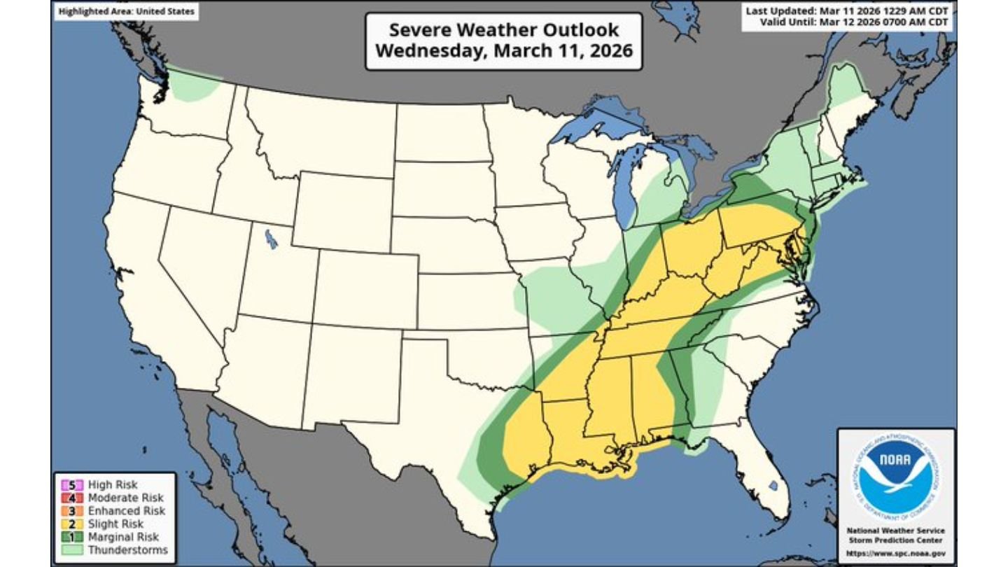
UNITED STATES — A broad corridor of unsettled and potentially dangerous weather is unfolding today from the Gulf Coast northward into the Ohio Valley, lower Great Lakes, and parts of the Mid-Atlantic, with the Storm Prediction Center placing a Slight Risk across a large swath of the eastern half of the country.
The latest severe weather outlook for Wednesday, March 11, 2026, highlights a multi-state threat zone stretching from Louisiana and Mississippi through Alabama, Tennessee, Kentucky, and Ohio, and into Pennsylvania, West Virginia, Maryland, and Virginia, with impacts potentially reaching toward the lower Great Lakes region.
Damaging Wind Threat Takes Center Stage
The primary hazard today will be damaging straight-line winds, with gusts of 60 to 70 mph possible across parts of the Ohio Valley and upper Mid-Atlantic.
The Severe Wind Outlook map shows the highest probabilities centered from:
- Eastern Kentucky
- Southern Ohio
- West Virginia
- Western and central Pennsylvania
This corridor is highlighted in enhanced wind probabilities, signaling the potential for scattered reports of tree damage, power outages, and structural impacts if storms organize into a fast-moving line.
Farther south, across Louisiana, Mississippi, and southwest Alabama, a “messy line segment” of storms is expected to develop. Stronger localized gusts are possible in this region, particularly where storms bow outward or cluster into short-lived segments.
Communities from New Orleans and Baton Rouge northward into Jackson, Mississippi, and east toward Mobile, Alabama, should be prepared for sudden bursts of wind capable of downing trees and producing scattered damage.
Tornado Risk: Isolated but Not Zero
While wind is the dominant concern, the Tornado Outlook indicates a corridor of tornado potential extending from the central Gulf Coast through the Tennessee Valley and into the Mid-Atlantic.
Two notable areas stand out:
- Louisiana, Mississippi, southwest Alabama, and the Florida Panhandle
- Eastern Kentucky, West Virginia, western Virginia, and parts of Pennsylvania
Most tornado probabilities remain in the lower ranges, but forecasters note that a few tornadoes are possible, including the potential for an isolated strong tornado, particularly in the southern risk zone where instability and wind shear overlap more favorably.
These setups often favor brief, embedded tornadoes within larger lines of storms, making them harder to detect visually and potentially forming quickly.
Hail Risk More Limited but Present
The Severe Hail Outlook shows a narrower axis of concern primarily across:
- The Tennessee Valley
- Eastern Kentucky
- West Virginia
- Western Virginia
Large hail appears to be a secondary threat today, but isolated stronger storms could still produce severe hailstones, especially where discrete cells briefly develop ahead of the main line.
Slight Risk Covers a Broad Swath of the East
The overall Severe Weather Outlook places a wide Slight Risk (Level 2 of 5) from the Gulf Coast northward to the lower Great Lakes.
States included within this broader risk area include:
- Louisiana
- Mississippi
- Alabama
- Tennessee
- Kentucky
- Ohio
- Indiana (southern portions)
- West Virginia
- Pennsylvania
- Maryland
- Virginia
This expansive zone underscores the widespread nature of today’s system, even though the highest impacts will likely be scattered rather than concentrated in one small region.
What This Means for Arkansas Readers
While Arkansas is not currently in the highlighted Slight Risk area today, the state sits just west of the main corridor of severe weather. Systems like this often track northeastward along strong frontal boundaries, and similar setups frequently impact Arkansas during spring severe weather season.
Residents across the risk areas should:
- Monitor local weather alerts
- Keep mobile devices charged
- Have multiple ways to receive warnings
- Remain especially alert during evening and overnight hours
Damaging winds can occur with little warning once storms organize, and isolated tornadoes — even if brief — can cause significant localized damage.
WaldronNews.com will continue monitoring developments as storms organize across the Gulf Coast and track toward the Ohio Valley and Mid-Atlantic. Stay weather aware and check back for updates as conditions evolve through the afternoon and evening hours.