
Ohio, Pennsylvania, West Virginia and Kentucky Under Heightened Severe Storm Risk as 49 Million Face Threat of Damaging Winds, 2-Inch Hail and Isolated Tornadoes
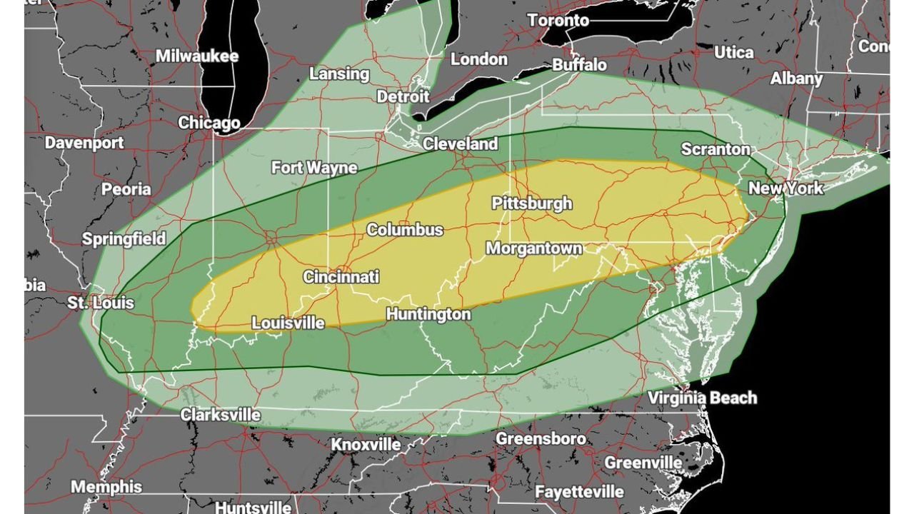
PITTSBURGH, PA — Nearly 49 million people across the Ohio Valley and central Appalachians are under a severe weather threat today as a powerful storm system targets portions of Ohio, Pennsylvania, West Virginia, Kentucky, Indiana and western New York.
Forecasters warn that damaging winds, very large hail up to 2 inches in diameter, and a few tornadoes are all possible as storms intensify later this afternoon and evening.
Most Intense Window: 4 PM to 8 PM
The most dangerous period is expected between 4 PM and 8 PM, when thunderstorms are forecast to organize into a more concentrated line stretching from parts of Louisville and Cincinnati through Columbus and Pittsburgh toward Scranton and New York City.
A secondary peak threat may occur between 7 PM and 8 PM as storms consolidate and accelerate eastward.
Cities within the highlighted risk zone include:
- Louisville, KY
- Cincinnati and Columbus, OH
- Huntington, WV
- Pittsburgh, PA
- Morgantown, WV
- Scranton, PA
- Portions of the New York metropolitan area
Primary Hazards: Wind and Large Hail
The greatest concern is damaging straight-line winds, which could down trees and power lines.
In addition, very large hail — potentially 2 inches or greater — may accompany stronger storms, posing a risk to vehicles, roofs and windows.
Forecasters indicate that hail and wind will likely be the dominant hazards across much of the region.
Low But Present Tornado Risk
While the tornado threat is not expected to be widespread, meteorologists note that a couple of tornadoes cannot be ruled out, particularly if sufficient low-level moisture becomes available ahead of the advancing storm line.
The tornado risk remains conditional, meaning it depends heavily on atmospheric moisture levels later today.
Storm Movement and Coverage
The severe weather area stretches broadly from:
- Eastern Indiana and western Ohio
- Across central and eastern Ohio
- Through western and central Pennsylvania
- Into northern West Virginia
- Extending toward parts of western New York
The risk zone also reaches southward toward parts of Kentucky and northward toward areas near Cleveland and Buffalo.
What Residents Should Do
With millions in the threat zone, residents are urged to:
- Monitor local weather alerts throughout the afternoon
- Secure loose outdoor items
- Be prepared to move indoors quickly if warnings are issued
- Have multiple ways to receive emergency notifications
Storms may intensify rapidly, leaving little time to react once warnings are issued.
Bottom Line
Today’s setup presents a dangerous combination of wind and hail across Ohio, Pennsylvania, West Virginia and Kentucky, with isolated tornado potential as storms organize this evening.
The highest risk period will unfold during the late afternoon and early evening hours.
Stay with WaldronNews.com for live updates as severe storms develop and move across the region.