
Ohio Storms Target Columbus and Dayton with Quarter to Ping Pong Ball Size Hail as Northern and Southern Metro Areas Take Direct Hits
COLUMBUS, OHIO — Strong thunderstorms rolled across central Ohio, bringing bursts of intense hail to the Columbus and Dayton metro areas, with radar indicating hail sizes ranging from quarter to ping pong ball diameter.
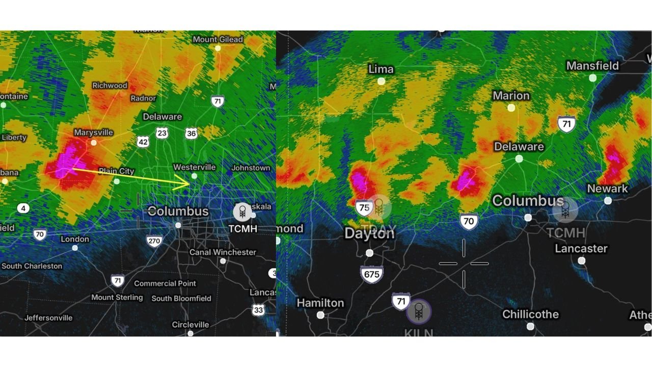
High-resolution radar imagery shows two distinct storm cores impacting different sections of the Columbus metro — one targeting the northern half near Marysville, Plain City, Delaware and Westerville, and another tracking across the southern portions toward I-70 and areas south of downtown.
Northern Metro: Marysville to Delaware Under Intense Core
Radar reflectivity shows a concentrated, high-intensity hail core moving from Marysville east toward Plain City and into northwestern Columbus.
Communities in the path included:
- Marysville
- Plain City
- Radnor
- Delaware
- Portions of Westerville
The bright pink and red radar returns indicate very strong updrafts capable of suspending hailstones large enough to reach quarter to ping pong ball size before falling.
Residents in the northern suburbs were urged to move vehicles under shelter as the storm passed through.
Southern Metro: Secondary Core Near I-70 Corridor
A second storm developed and intensified west of Columbus, pushing through areas near:
- Dayton
- Along Interstate 75
- Eastward toward Columbus and the I-70 corridor
This second cell focused more on the southern half of the metro area, bringing another round of hail-producing downpours.
Radar signatures show strong reflectivity cores embedded within broader rain shields — classic indicators of localized hail bursts.
Dayton Also Impacted
Further west, radar imagery near Dayton and I-75 shows a separate strong cell with a defined hail core.
Communities between Dayton and Columbus experienced repeated rounds of storms as the line progressed eastward.
Hail Size and Impact
Estimates suggest hail ranging from:
- Quarter size (1 inch)
- Up to Ping pong ball size (1.5 inches)
While this size typically does not shatter windshields, it can:
- Dent vehicles
- Damage siding
- Impact young vegetation
The storms appeared highly localized, meaning impacts varied neighborhood to neighborhood.
Storm Structure and Movement
The radar shows storms moving generally east to east-southeast, with strong updraft regions embedded within a broader severe weather environment across central Ohio.
The presence of multiple hail cores suggests a moderately unstable atmosphere with enough wind shear to support organized storm segments.
What Residents Should Watch For
Even after the initial hail cores pass, additional storms may redevelop along the boundary. Residents across:
- Columbus
- Delaware
- Westerville
- Dayton
- Areas along I-70 and I-75
should remain weather-aware.
Bottom Line
Two separate storm cores swept across Columbus and Dayton, Ohio, delivering bursts of quarter to ping pong ball size hail across both the northern and southern halves of the metro.
Localized damage is possible, particularly to vehicles and outdoor property.
Stay with WaldronNews.com for continuing severe weather updates as storms move across Ohio.