
Ohio and Pennsylvania Severe Thunderstorm Line Tracks from Wooster to Pittsburgh with 10–11 PM Arrival Window for Southwest Pennsylvania
WOOSTER, OHIO — A strong line of thunderstorms pushing east from Wooster, Ohio is expected to move into southwest Pennsylvania between 10:00 PM and 11:00 PM EDT, according to the latest radar estimates.
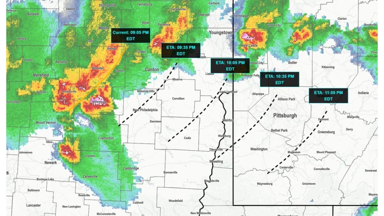
Storm tracking imagery shows a well-organized line extending from near Mansfield and Loudonville through Wooster and toward Canton, with forward motion aimed directly at the Ohio–Pennsylvania border.
Forecasters indicate that if the storms do not weaken within the next 30–45 minutes, the current Severe Thunderstorm Watch may need to be extended to a later expiration time.
Current Position and Movement
As of approximately 9:05 PM EDT, the strongest storms were located near:
- Wooster
- Loudonville
- Just west of Canton
Embedded cores within the line show intense reflectivity, suggesting heavy rain and possible strong wind gusts as the storms continue east.
Projected arrival times based on current motion:
- Around 9:35 PM EDT: Near eastern Ohio communities approaching the state line
- Around 10:05 PM EDT: Crossing into western Pennsylvania
- Around 10:35 PM EDT: Approaching greater Pittsburgh
- Around 11:05 PM EDT: Moving east of Pittsburgh toward Greensburg and surrounding areas
Areas in the Path
Communities likely to be impacted include:
In Ohio:
- Wooster
- Canton
- Areas south of Mansfield
- Locations near New Philadelphia and Carrollton
In Pennsylvania:
- Beaver Falls
- Aliquippa
- Greater Pittsburgh
- Allison Park
- Greensburg
The storm line is moving generally west to east, with embedded stronger cells producing heavier precipitation cores.
Potential Hazards
Radar signatures indicate:
- Strong straight-line winds
- Heavy downpours reducing visibility
- Frequent lightning
While no confirmed tornado signatures are visible in the provided imagery, the linear structure can still produce localized damaging wind gusts.
Watch Extension Possible
Forecasters are monitoring whether the line maintains strength as it pushes east. If storms remain organized and intense, officials may extend the existing Severe Thunderstorm Watch beyond its current expiration time to cover additional hours into the late evening.
The next 30–45 minutes will be critical in determining whether the system sustains its structure or begins to weaken before crossing fully into Pennsylvania.
Bottom Line
A strong thunderstorm line is advancing from Wooster and Canton, Ohio, toward Pittsburgh, Pennsylvania, with arrival in southwest Pennsylvania expected between 10 PM and 11 PM EDT. If weakening does not occur soon, a watch extension is possible.
Residents in eastern Ohio and western Pennsylvania should remain weather-aware through the late evening hours.
Stay with WaldronNews.com for continued updates as this storm system progresses across the Ohio–Pennsylvania border.