
Illinois, Indiana, Ohio, Kentucky in Enhanced Risk Zone as Severe Storm Threat Intensifies Across Mid-Mississippi and Ohio Valley Thursday
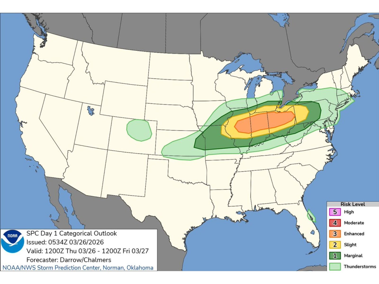
MID-MISSISSIPPI VALLEY, OHIO VALLEY — A significant severe weather setup is expected to unfold Thursday, with an Enhanced Risk (Level 3 of 5) stretching across portions of the Mid-Mississippi Valley into the Ohio Valley, signaling an increased likelihood of impactful thunderstorms across multiple states.
The highest concentration of severe weather potential is forecast to impact areas including Illinois, Indiana, Ohio, and Kentucky, where conditions appear most favorable for organized storms capable of producing damaging weather.
Enhanced Risk Corridor Targets Central Midwest and Ohio Valley
The core of the Enhanced Risk zone forms a broad corridor extending from eastern Missouri and southern Illinois through Indiana and into much of Ohio.
Within this zone, cities and surrounding areas that could see the most significant impacts include:
- St. Louis region and southern Illinois
- Central and southern Indiana, including Indianapolis
- Much of Ohio, including Columbus and Cincinnati
- Northern and central Kentucky, including Louisville
This area represents the region where storm intensity and coverage are expected to be greatest, with a higher probability of severe weather reports.
Surrounding Areas Under Slight and Marginal Risk
Surrounding the Enhanced Risk zone is a wider Slight Risk (Level 2) area that extends into parts of:
- Michigan
- Pennsylvania
- West Virginia
- Tennessee
- Arkansas and nearby regions
A broader Marginal Risk (Level 1) area stretches even farther, indicating that isolated severe storms are possible across a large portion of the eastern United States.
Timing Window Covers Thursday Into Early Friday
The outlook is valid from Thursday morning through early Friday morning, with storms expected to develop and intensify during the afternoon and evening hours before continuing overnight.
This extended window increases the potential for multiple rounds or clusters of storms moving through the region.
Conditions Favor Organized Severe Thunderstorms
The overall setup suggests a favorable environment for organized storm development across the region.
With a strong system moving through and ample moisture in place, storms may become more widespread and intense, particularly within the Enhanced Risk zone.
While specific hazards will depend on storm evolution, setups like this often bring the potential for:
- Damaging winds
- Large hail
- Isolated tornadoes
Broad Coverage Highlights Widespread Impact Potential
One of the key concerns with this system is its geographic reach, with severe weather possible across multiple states simultaneously.
The alignment of the risk zones indicates a large-scale weather pattern capable of producing storms across a wide corridor rather than isolated pockets.
What Residents Should Watch
As the event approaches, forecast updates will refine:
- Exact storm timing by location
- Specific hazard threats in each area
- Potential for stronger or more widespread impacts
Residents across Illinois, Indiana, Ohio, Kentucky, and surrounding states should remain alert and prepared for rapidly changing weather conditions Thursday into Thursday night.
Waldron News will continue tracking this developing severe weather threat and provide updates as more detailed information becomes available.